 ICES Metadata Catalogue
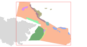
Habitats LIC Sistema de Ca├▒ones Submarinos Occidentales del Golfo de Le├│n
This dataset contains the habitats map from the SCI (Site of Community Importance) ÔÇ£Sistema de Ca├▒ones Submarinos Occidentales del Golfo de Le├│nÔÇØ. The marine area ÔÇ£South-West Gulf of Lions canyons systemÔÇØ is located in the northeastern part of the Iberian Peninsula. The coastline belongs to the Catalan province of Girona, featuring a large number of rocky outcrops with many coves, small beaches, vertical cliffs and islets. Cape Creus is the most notorious element of the landscape, which corresponds to the easternmost part of the Pyrenees Mountains. This small peninsula is characterized by its wildness, and despite its low relief it penetrates into the Mediterranean Sea for more than 10 kilometers.This study was supported by the INDEMARES-LIFE+ Project, EC contract INDEMARES-LIFE+ (07/NAT/E/000732): Inventory and Designation of the Natura 2000 network in marine areas of the Spanish State (www.indemares.es/en). This work was coordinated by the Biodiversity Foundation (www.fundacion-biodiversidad.es). Habitats are classified according to EUNIS nomenclature and the List of Marine Habitats in Spain (LPRE, that itÔÇÖs classified hierarchically and was completed and published in March 2013). Habitats classification are been simplified owing to the requirements of the EMODnet (European Marine Observation and Data Network) portal for Seabed Habitats.
Simple
- Alternate title
-
ES001026
- Date (Revision)
- 2015-10-05T00:00:00
- Presentation form
- Digital map
- Purpose
-
Marine habitats research and seabed habitats distribution mapping for Marine Natura 2000 Network areas declaration. It was performed with geophysical data and direct and indirect samplings obtained in the Project INDEMARES Sistema de Ca├▒ones Submarinos Occidentales del Golfo de Le├│n (South-West Gulf of Lions canyons system) (LIFE+ 07/NAT/E/000732). The study area is situated in the northeastern part of the Iberian Peninsula (Mediterranean Sea).
- Status
- Completed
- Point of contact
-
Organisation name Individual name Electronic mail address Role Fundaci├│n Biodiversidad (Biodiversity Fundation)
Fundaci├│n Biodiversidad
indemares@fundacion-biodiversidad.es
Point of contact Institute of Marine Sciences in Barcelona - CSIC (Spanish National Research Council)
Institut de Ciències del Mar
secredir@icm.csi secredir@icm.csic.es
Owner Institut de Ciències del Mar - CSIC
Josep-Maria Gili
gili@icm.csi gili@icm.csic.es
Principal investigator INSTITUTO ESPAÑOL DE OCEANOGRAFÍA (Spanish Institute of Oceanography) (IEO)
Alberto Serrano L├│pez
aserrano@st.ieo aserrano@st.ieo.es
Principal investigator
- Maintenance and update frequency
- As needed
- Theme
-
-
Marine habitat mapping, INDEMARES, LIFE, LIFE+, Institut of Marine Sciences, ICM, CSIC, Instituto Español de Oceanografía, FUNDACIÓN BIODIVERSIDAD, EMODNET, EUSeaMap, Mediterranean Sea, Golfo de León, Gulf of Lions, Cape Creus, Benthos, Bentos, Habitat, Hábitat, Seabed, Fondo marino
-
-
GEMET - INSPIRE themes, version 1.0
-
-
Habitats and biotopes, Hábitats y biotopos, Protected sites, Lugares protegidos, Species distribution, Distribución de las especies, Rasgos oceanográficos, Hidrografía, Geology, Geología, Biology, Biología
-
- Use limitation
-
The use of this information, totally or partly, requires the source citation: Spanish Institute of Oceanography (IEO, www.ieo.es) and Biodiversity Fundation (www.fundacion-biodiversidad.es), Spain.
- Access constraints
- Copyright
- Use constraints
- Other restrictions
- Other constraints
-
The use of this information, totally or partly, requires the source citation: Spanish Institute of Oceanography (IEO, www.ieo.es) and Biodiversity Fundation (www.fundacion-biodiversidad.es), Spain.
- Spatial representation type
- Vector
- Denominator
- 95000
- Language
-
eng
- Character set
- UTF8
- Topic category
-
- Environment
- Begin date
- 2010-10-01T00:00:00
- End date
- 2013-12-02T00:00:00
))
Vertical extent
- Minimum value
- 100000
- Maximum value
- 8000
- Reference system identifier
- WGS 1984
- Distribution format
-
Name Version Shapefile
ESRI ArcGIS 10.1
- OnLine resource
-
Protocol Linkage Name WWW:DOWNLOAD-1.0-http--download
http://gis.ices.dk/geonetwork/srv/en/resources.get?id=723&fname=&access=private OGC:WMS
https://ows.emodnet-seabedhabitats.eu/geoserver/emodnet_view_maplibrary/wms? es001026
OGC:WFS
https://ows.emodnet-seabedhabitats.eu/geoserver/emodnet_open_maplibrary/wfs? es001026
WWW:LINK-1.0-http--link
https://files.emodnet-seabedhabitats.eu/data/EMODnetSBHsurvey_ES001026.zip EMODnet Seabed Habitats download
- Hierarchy level
- Dataset
Conformance result
- Date (Publication)
- 2015-10-05
- Explanation
-
EMODnetSBH Confidence assessment scoresheet = 89
- Pass
- Yes
- Statement
-
EMODNET
Metadata
- File identifier
- 8304512f-94cf-4174-a4d5-fef00b05b1c0 XML
- Metadata language
-
eng
- Character set
- UTF8
- Date stamp
- 2020-01-23T11:20:25
- Metadata standard name
-
ISO 19115:2003/19139
- Metadata standard version
-
1.0
- Metadata author
-
Organisation name Individual name Electronic mail address Role INSTITUTO ESPAÑOL DE OCEANOGRAFÍA (Spanish Institute of Oceanography) (IEO)
Instituto Español de Oceanografía (IEO)
Point of contact INSTITUTO ESPAÑOL DE OCEANOGRAFÍA (Spanish Institute of Oceanography) (IEO)
Olvido Tello Ant├│n
olvido.tello@md.ieo olvido.tello@md.ieo.es
Custodian
Overviews
Spatial extent
Provided by
