 ICES Metadata Catalogue
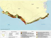
Benthic communities in the north littoral of strait of Gibraltar
Cartography of benthic communities to promoting adequate strategies for the use, management and conservation of littoral areas depending on the ecological value of the different benthic communities established and on the local geographical distribution.
Simple
- Alternate title
-
ES001002
- Date (Publication)
- 2003-12-01T12:22:00
- Presentation form
- Digital map
- Purpose
-
Submarine cartographic for managing and conserving littoral areas: Mapping the benthic communities of the northern coast of the Strait of Gibraltar.
- Status
- Completed
- Point of contact
-
Organisation name Individual name Electronic mail address Role University of Seville
Jose Carlos García-Gómez
Originator
- Maintenance and update frequency
- As needed
- Theme
-
-
Benthic communities
-
- Place
-
-
Marine habitat mapping
-
Cádiz
-
Southwest Spain
-
-
GEMET - INSPIRE themes, version 1.0
-
-
Habitats and biotopes
-
- Use limitation
-
The access and use is possible with request to the University of Seville
- Access constraints
- Copyright
- Use constraints
- Copyright
- Spatial representation type
- Vector
- Denominator
- 100000
- Language
-
eng
- Character set
- UTF8
- Topic category
-
- Environment
))
- Begin date
- 2003-12-01T14:29:00
- End date
- 2003-12-01T14:30:00
Vertical extent
- Minimum value
- -30
- Maximum value
- 0
- Reference system identifier
- WGS 1984
- Distribution format
-
Name Version Jose Carlos García-Gómez
2003-12-01
- OnLine resource
-
Protocol Linkage Name WWW:LINK-1.0-http--link
http://www.ieo.es/publicaciones/boletin/pdfs/bol19/19%20(1-4)%20149-163.pdf OGC:WMS
https://ows.emodnet-seabedhabitats.eu/geoserver/emodnet_view_maplibrary/wms? es001002
OGC:WFS
https://ows.emodnet-seabedhabitats.eu/geoserver/emodnet_open_maplibrary/wfs? es001002
WWW:LINK-1.0-http--link
https://files.emodnet-seabedhabitats.eu/data/EMODnetSBHsurvey_ES001002.zip EMODnet Seabed Habitats download
- Hierarchy level
- Dataset
Conformance result
- Date (Publication)
- 2003-12-01
- Explanation
-
Submarine cartographic for managing and conserving littoral areas: Mapping the benthic communities of the northern coast of the Strait of Gibraltar.
- Pass
- Yes
Metadata
- File identifier
- 7e3da8b3-5aca-4bf0-a7a8-94f9567a6c95 XML
- Metadata language
-
eng
- Character set
- UTF8
- Date stamp
- 2020-01-15T12:28:25
- Metadata standard name
-
ISO 19115:2003/19139
- Metadata standard version
-
1.0
- Metadata author
-
Organisation name Individual name Electronic mail address Role Spanish Institute of Oceanography
Dulce Mata Chac├│n
dulce.mata@md.ieo dulce.mata@md.ieo.es
Point of contact
Overviews
Spatial extent
Provided by
