 ICES Metadata Catalogue
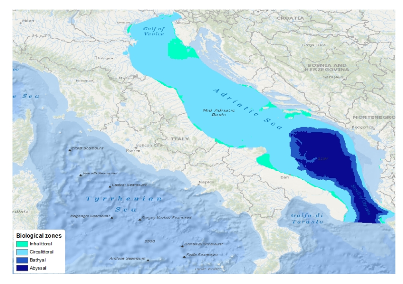
Biological zones of the Adriatic Sea - Scale 1:1,000,000
This layer is a model of the biological zones of the Adriatic Sea. It was performed within the framework of EMODnet Phase 2 Thematic Lot n┬░ 3 (aka EUSeaMap2). It is a preliminary version which will be refined during the course of the project.
This layer was modelled with the use of base layers that were the seabed substrate type (obtained from EMODnet phase 2 Geology lot, June 2014 release), the bathymetry (EMODnet phase 1 Hydrography lot) and the kdpar (bespoke computed layer)
The biological zones boundaries were defined in the following way.
- Infralittoral lower limit: limit at which the percentage of light reaching the seabed is 1%. The percentage of light layer was calculated by intersecting the kdpar and the bathymetry layers. For more details about this calculation see e.g. Cameron and Askew (2011).
- Circalittoral lower limit: break of slope due to the entrance into the continental slope. This limit was digitalized with the use of the bathymetry layer
- Bathyal lower limit: break of slope due to the entrance into the abyssal plain. This limit was digitalized with the use of the bathymetry layer
In a western area for which the seabed substrated type is influenced by the P├┤ river, different rules were used for the definition infralittoral and circalittoral zones.
Where the substrate is muddy (i.e. mud or sandy mud) and/or the seabed is deeper than 20 meters then the biological zone was said to be circalittoral. Elsewhere it was defined as infralittoral.
For more details about the current layer see EUSeaMap first year report (EMODnet Thematic Lot n┬░ 3, 2014)
Cameron, A., Askew, N. (eds.), 2011. EUSeaMap - Preparatory Action for development and assessment of a European broad-scale seabed habitat map final report. URL: http://jncc.gov.uk/euseamap
EMODnet Thematic Lot n┬░ 3, 2014. EMODnet Phase 2 - Annual (interim) report. Reporting Period: Sept. 2013 to Aug. 2014. URL: http://www.emodnet-seabedhabitats.eu/pdf/20140909_euseamap2_year1_report.pdf
Simple
- Date (Publication)
- 2014-10-10T08:00:00
- Edition
-
v1
- Presentation form
- Digital map
- Purpose
-
Marine spatial planning
Marine protected areas design
- Status
- Completed
- Point of contact
-
Organisation name Individual name Electronic mail address Role Ifremer
Mickaël VASQUEZ
Point of contact
- Maintenance and update frequency
- As needed
- Theme
-
-
biological zones
-
Etage
-
Infralittoral
-
Circalittoral
-
Bathyal
-
Abyssal
-
Adriatic
-
Marine habitat mapping
-
-
GEMET - INSPIRE themes, version 1.0
-
-
Habitats and biotopes
-
Oceanographic geographical features
-
Bio-geographical regions
-
Hydrography
-
- Use limitation
-
Data is freely available for research or commercial use providing that the originators are acknowledged in any publications produced
- Other constraints
-
has to be cited this way in other maps: "Source EMODnet"
- Spatial representation type
- Vector
- Denominator
- 1000000
- Language
-
eng
- Character set
- UTF8
- Topic category
-
- Environment
- Begin date
- 2014-10-16T04:00:00
- End date
- 2014-10-16T04:00:00
))
Vertical extent
- Minimum value
- 0
- Maximum value
- 6000
- Reference system identifier
- WGS 1984
- Distribution format
-
Name Version Esri Shapefile unknown
- OnLine resource
-
Protocol Linkage Name WWW:LINK-1.0-http--link
http://www.emodnet-seabedhabitats.eu/default.aspx?page=1934 WWW:DOWNLOAD-1.0-http--download
http://gis.ices.dk/geonetwork/srv/en/resources.get?id=594&fname=&access=private OGC:WMS-1.1.1-http-get-map
- Hierarchy level
- Dataset
Conformance result
- Title
-
Biological zones of the Adriatic Sea
- Date (Publication)
- 2014-10-15
- Explanation
-
Calculation
- Pass
- No
Metadata
- File identifier
- fdd571ff-375a-44d7-91d3-559cf1a3d382 XML
- Metadata language
-
eng
- Character set
- UTF8
- Parent identifier
-
Broad-scale habitat map of the Adriatic Sea - Scale 1:1,000,000
b340f9ec-527a-4d05-a68b-aac99cd14c74
- Date stamp
- 2026-03-11T09:23:39.282329Z
- Metadata standard name
-
ISO 19115:2003/19139
- Metadata standard version
-
1.0
- Metadata author
-
Organisation name Individual name Electronic mail address Role Ifremer
Mickaël Vasquez
Point of contact
)))