 ICES Metadata Catalogue
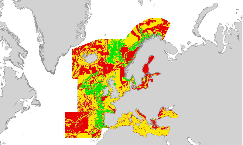
EUSeaMap2 (2016) Broad-Scale Predictive Habitat Map - Confidence in Oxygen Regime
Confidence in the 2016 EUSeaMap Oxygen regime class layer, produced by EMODnet Seabed Habitats for the 2016 EUSeaMap broad-scale predictive habitat maps in the Black Sea.
Values are on a range from 1 (Low confidence) to 3 (High confidence).
Detailed information on the confidence assessment in
Populus J. et al 2017. EUSeaMap, a European broad-scale seabed habitat map. Ifremer. http://doi.org/10.13155/49975
Simple
- Date (Revision)
- 2017-06-12
- Date (Publication)
- 2016-09-30
- Credit
-
EMODnet broad-scale seabed habitat map for Europe (2016), licensed under CC-BY 4.0 from the European Marine Observation and Data Network (EMODnet) Seabed Habitats initiative (www.emodnet-seabedhabitats.eu), funded by the European Commission.
- Status
- Completed
- Point of contact
-
Organisation name Individual name Electronic mail address Role EMODnet Seabed Habitats
euseamap@jncc.gov euseamap@jncc.gov.uk
Owner
-
GEMET - INSPIRE themes, version 1.0
-
-
Habitats and biotopes
-
- Use limitation
-
Licensed under CC-BY 4.0 - please use attribution statement included within the "Credit" element.
- Access constraints
- Other restrictions
- Other constraints
-
Licensed under CC-BY 4.0 - please use attribution statement included within the "Credit" element.
- Access constraints
- Other restrictions
- Denominator
- 250000
- Denominator
- 250000
- Language
- English
- Topic category
-
- Biota
- Environment
- Oceans
))
- Begin date
- 1975-01-01
- End date
- 2015-12-31
- Reference system identifier
- EPSG / WGS 84 (EPSG:4326) / 7.4
- Distribution format
-
Name Version Web Mapping Service
1.1.0
- OnLine resource
-
Protocol Linkage Name WWW:LINK-1.0-http--link
http://www.emodnet-seabedhabitats.eu/access-data/launch-map-viewer/?LAYERS=EUSMOXYREG_C&zoom=5&Y=43.55&X=31.4 EMODnet Seabed Habitats interactive map
WWW:LINK-1.0-http--link
http://www.emodnet-seabedhabitats.eu/access-data/download-data/?linkid=1 EMODnet Seabed Habitats download page - EUSeaMap preselected
OGC:WMS-1.1.1-http-get-map
http://52.49.27.224/geoserver/wms? eusm2016_conf_oxyreg
WWW:LINK-1.0-http--link
http://archimer.ifremer.fr/doc/00388/49975/ EUSeaMap. A European broad-scale seabed habitat map
- Hierarchy level
- Dataset
Conformance result
- Date (Publication)
- Pass
- Statement
-
For details on methodology and input layers see:
Populus J. And Vasquez M. (Eds), 2017. EUSeaMap, a European broad-scale seabed habitat map. Ifremer
Available from: http://archimer.ifremer.fr/doc/00388/49975/
Metadata
- File identifier
- f82934be-c499-470e-91c7-74ba4849dad6 XML
- Metadata language
- English
- Character set
- MD_CharacterSetCode_utf8
- Hierarchy level
- Dataset
- Hierarchy level name
-
a
- Hierarchy level name
-
b
- Date stamp
- 2020-01-15T12:23:50
- Metadata standard name
-
ISO19115
- Metadata standard version
-
2003/Cor.1:2006
- Metadata author
-
Organisation name Individual name Electronic mail address Role EMODnet Seabed Habitats
euseamap@jncc.gov euseamap@jncc.gov.uk
Point of contact
Overviews

Spatial extent
Provided by
