 ICES Metadata Catalogue
FisheriesXplorer (shiny app)
ICES has developed the ICES fisheriesXplorer, an interactive, web-based application to enhance accessibility, transparency, and usability of fisheries assessment data and advice. Built using R’s Shiny framework, it connects directly via database API's to ICES databases and services, ensuring that the data displayed remain always up-to-date and aligned with FAIR (Findable, Accessible, Interoperable, Reusable) principles.
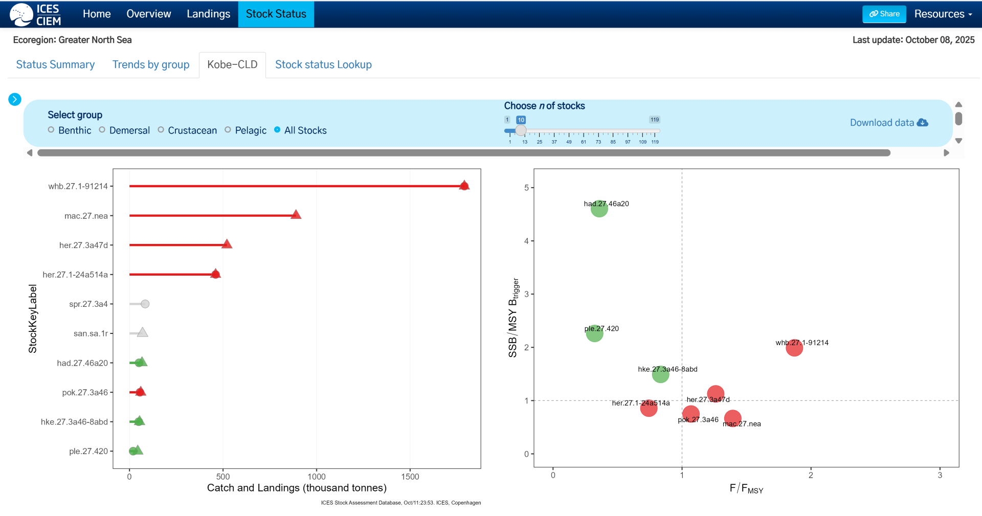
fisheriesXplorer visualizes fishing activities across ICES ecoregions, integrating outputs from the Fisheries Overviews, including:
-Ecoregion overviews
-Landings and discards time-series
-Stock status: Summary; Trends; Lookup
fisheriesXplorer will continue to be updated with new visualisations to further the impact of fisheries science.
Simple
Identification info
- Date (Publication)
- 2025-11-30T08:00:00
- Purpose
-
Provides insight into fisheries activities, impact and stock status in the ICES area
- Point of contact
-
Organisation name Individual name Electronic mail address Role ICES
Data Manager
Point of contact
- Maintenance and update frequency
- Continual
- Metadata author
-
Organisation name Individual name Electronic mail address Role ICES
Neil Maginnis
Custodian
-
ISO 19119 service taxonomy
-
-
ICES
-
- Keywords
-
-
ICES Service
-
Shiny
-
ICES
-
Interactive
-
Stock Status
-
Ecosystem Based Fisheries Management
-
Advice
-
Fisheries
-
- Access constraints
- Other restrictions
- Other constraints
- no limitations to public access
- Use constraints
- Other restrictions
- Other constraints
-
Available under the Creative Commons Attribution (CC-BY) License v4.0
- Use limitation
-
Available under the Creative Commons Attribution (CC-BY) License v4.0
- Use limitation
-
Data is available under the terms of the ICES Data Policy. (See: https://ices.dk/data/guidelines-and-policy/Pages/ICES-data-policy.aspx)
- Service Type
- view
- Keyword
-
ICES
- Coupling Type
- Loose
- Contains Operations
-
Operation Name Distributed Computing Platforms Connect Point https://ices-taf.shinyapps.io/fisheriesXplorer/
- OnLine resource
-
Protocol Linkage Name WWW:LINK-1.0-http--link
https://github.com/ices-tools-dev/fisheriesXplorer Source code
- Hierarchy level
- Service
- Other
-
service
Conformance result
- Title
-
commission regulation (eu) no 1089/2010 of 23 november 2010 implementing directive 2007/2/ec of the european parliament and of the council as regards interoperability of spatial data sets and services
- Date (Publication)
- 2010-12-08
- Pass
- Yes
- Statement
-
The tool draws on a number of sources, including ICES data products and annual Data Calls. These are outlined below:
ICES Stock Information Database. 2025. ICES, Copenhagen, Denmark. https://sid.ices.dk
ICES Stock Assessment Database. Copenhagen, Denmark. ICES. [accessed date]. https://standardgraphs.ices.dk
ICES (2025). ICES Fisheries Data call 2025 for landings, discards, biological sample, catch and effort data. Data Calls. Report. https://doi.org/10.17895/ices.pub.28227779.v2
Official Nominal Catches 2006-2023
Catches in FAO area 27 by country, species, area and year as provided by the national authorities. Source: Eurostat/ICES data compilation of catch statistics - ICES 2025, Copenhagen. Format: Archived dataset in .xlsx and .csv formats. Version: 10-10-2025
Historical Nominal Catches 1950-2010
Catches in FAO area 27 by country, species, area and year. Source: Eurostat/ICES database on catch statistics - ICES 2011, Copenhagen. Format: Archived dataset in .xls and .csv format. Version 26-06-2019
ICES Historical Landings 1903-1949
Catches in FAO area 27 by country, year, area, and species. Source: Bulletin Statistique. Format: Archived dataset in .xlsx and .csv formats. Version: 28-10-2014
National experts contribute data on the composition and targeting behaviour of their respective fisheries
ICES (2025). ICES Data call 2025 - Data submission of VMS/Log book data. Data Calls. Report. https://doi.org/10.17895/ices.pub.29146643.v1
Metadata
- File identifier
- f51bc2ed-d1ee-42ac-bbc4-d2f3a2f0d7d1 XML
- Metadata language
- English
- Hierarchy level
- Service
- Hierarchy level name
-
Web service
- Date stamp
- 2026-05-28T09:18:08.60396Z
- Metadata standard name
-
INSPIRE Metadata Implementing Rules
- Metadata standard version
-
Technical Guidelines based on EN ISO 19115 and EN ISO 19119 (Version 1.2)
- Metadata author
-
Organisation name Individual name Electronic mail address Role ICES
Point of contact
)