 ICES Metadata Catalogue
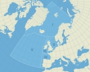
OSPAR Regions
Delineation of the OSPAR Regions in the OSPAR maritime area. The delineation does not include a coastline and the polygons overlap with land.
Simple
- Date (Revision)
- 2009-12-15T00:00:00
- Presentation form
- Digital map
- Status
- On going
- Point of contact
-
Organisation name Individual name Electronic mail address Role OSPAR Secretariat
Originator ICES Secretariat
accessions.ices.dk
Distributor
- Maintenance and update frequency
- As needed
- Place
-
-
OSPAR maritime area
-
-
GEMET - INSPIRE themes, version 1.0
-
-
Administrative units
-
- Use limitation
-
Data is available under the terms of the ICES Data Policy. (See: https://ices.dk/data/guidelines-and-policy/Pages/ICES-data-policy.aspx)
- Access constraints
- Other restrictions
- Use constraints
- Other restrictions
- Other constraints
-
Data is available under the terms of the ICES Data Policy. (See: https://ices.dk/data/guidelines-and-policy/Pages/ICES-data-policy.aspx)
- Spatial representation type
- Vector
- Language
-
eng
- Character set
- UTF8
- Topic category
-
- Boundaries
))
- Reference system identifier
- WGS 1984
- OnLine resource
-
Protocol Linkage Name WWW:LINK-1.0-http--link
FILE:GEO
https://gis.ices.dk/shapefiles/OSPAR_Subregions.zip OSPAR Subregions shapefile
- Hierarchy level
- Dataset
Metadata
- File identifier
- ec78a170-2110-4c0a-b115-61f3b51022e6 XML
- Metadata language
-
eng
- Character set
- UTF8
- Date stamp
- 2022-04-28T16:25:26.948Z
- Metadata standard name
-
ISO 19115:2003/19139
- Metadata standard version
-
1.0
- Metadata author
-
Organisation name Individual name Electronic mail address Role ICES
Point of contact
Overviews

Spatial extent
Provided by
