 ICES Metadata Catalogue
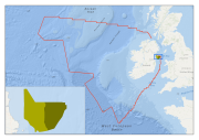
North Irish Sea Nephrops Habitat
Targetted fishing ground for Nephrops norvegicus determined from Vessel Monitoring System data. The original classes assigned to the data were translated to the EUNIS habitat classification system as part of the MESH Atlantic project.
Simple
- Alternate title
-
IE001007
- Date (Publication)
- 2013-07-02
- Date (Creation)
- 2013-07-02
- Date (Revision)
- 2013-07-02
- Citation identifier
- INSPIRE form / IE.MI.HB.MESH.ATLANTIC.NorthIrishSea.NephropsHabitat
- Purpose
-
Base layer to verify predicted seabed habitats.
- Status
- Completed
- Point of contact
-
Organisation name Individual name Electronic mail address Role Marine Institute
Advanced Mapping Services
Point of contact
- Maintenance and update frequency
- Not planned
-
GEMET - Concepts, version 2.4
-
-
habitat, sea, sea bed, biotope, classification
-
-
GEMET - Concepts, version 2.4
-
-
substrate
-
-
INSPIRE Feature Concept Dictionary
-
-
Habitats and biotopes
-
- Use limitation
-
no conditions apply
- Access constraints
- Other restrictions
- Other constraints
-
Marine Institute Data Licence
- Spatial representation type
- Vector
- Distance
- 1 http://standards.iso.org/ittf/PubliclyAvailableStandards/ISO_19139_Schemas/resources/uom/ML_gmxUom.xml#m
- Denominator
- 100000
- Language
- English
- Character set
- UTF8
- Topic category
-
- Oceans
- Geoscientific information
- Environment
))
- Begin date
- 2002-01-01T00:00:00
- End date
- 2011-12-31T00:00:00
Vertical extent
- Minimum value
- -100
- Maximum value
- -30
Vertical CS
Vertical datum
- Supplemental Information
-
Polygon shapefile.
- Reference system identifier
-
urn:ogc:def:crs:EPSG
/
4326
EPSG Geodetic Parameter Dataset EPSG 2009-11-25
- Distribution format
-
Name Version Esri shapefile
ArcGIS 10
- Distributor contact
-
Organisation name Individual name Electronic mail address Role Marine Institute
Advanced Mapping Services
Point of contact
- OnLine resource
-
Protocol Linkage Name OGC:WMS
https://ows.emodnet-seabedhabitats.eu/geoserver/emodnet_view_maplibrary/wms? ie001007
OGC:WFS
https://ows.emodnet-seabedhabitats.eu/geoserver/emodnet_open_maplibrary/wfs? ie001007
WWW:LINK-1.0-http--link
https://files.emodnet-seabedhabitats.eu/data/EMODnetSBHsurvey_IE001007.zip EMODnet Seabed Habitats download
- OnLine resource
-
Protocol Linkage Name WWW:LINK-1.0-http--link
http://www.meshatlantic.eu/ Project description
WWW:LINK-1.0-http--link
https://files.emodnet-seabedhabitats.eu/data/EMODnetSBHsurvey_IE001007.zip EMODnet Seabed Habitats download
- Hierarchy level
- Dataset
Conformance result
- Alternate title
-
INSPIRE Data Specifications v3.0
- Date (Publication)
- 2011-06-15
- Explanation
-
The INSPIRE Directive or INSPIRE lays down a general framework for a Spatial Data Infrastructure (SDI) for the purposes of European Community environmental policies and policies or activities which may have an impact on the environment.
- Pass
- No
- Statement
-
The habitat data were generated from the analysis of Vessel Monitoring System (VMS) data for boats targetting Nephrops norvegicus. The extent and boundary of the mud class was derived from the dense concentration of fishing activity highlighted on the VMS data. All original classifications assigned to the habitats were translated to EUNIS using expert judgement and additional data.
Metadata
- File identifier
- e3977cb7-fac1-49e2-8685-4067efcab49c XML
- Metadata language
- English
- Character set
- UTF8
- Hierarchy level
- Dataset
- Date stamp
- 2021-10-29T11:41:23
- Metadata standard name
-
Based on ISO 19115:2005/19139:2007 INSPIRE Directive 2007/2/EC Metadata Implementing Rules
- Metadata standard version
-
1.2 INSPIRE Metadata Implementing Rules
- Metadata author
-
Organisation name Individual name Electronic mail address Role Marine Institute
Advanced Mapping Services
Point of contact
Overviews
Spatial extent
Provided by
