 ICES Metadata Catalogue
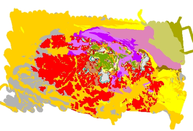
Cartographie des habitats benthiques du secteur des Gl├®nan (REBENT, 2006)
This comprehensive map of the benthic communities of Les Gl├®nan is realized as part of the REBENT programme, i.e. the surveying network for the benthic fauna and flora. It is the result of the treatment, the analysis and the data aggregation from authors and multiple specialized agencies :
- ORTHOLITTORALE 2000,
- IFREMER, Lidar altimetry in 2005,
- M. Le Hir, S. Chauvaud, G. Robert, from the engineering firm " T├®l├®d├®tection et Biologie Marine " (TBM) in 2005,
- N. Alloncle, student at the Brest University in 2005,
- CEVA in 2004 and 2005,
- Bathymetric data from SHOM,
- Rebent intertidal and subtidal field studies data collected between 2003 and 2006.
For these studies, various methods were used : coastal orthophotography, altimetric data from LIDAR, acoustic techniques, benthic sampling techniques, intertidal surveys.
The habitat typology held for the cartography is the EUNIS classification, the European reference (October, 2004 version).
In the rocky sectors, groupings of EUNIS classes were realized when the EUNIS typology was difficult to apply. It allows describing more easily the various environments.
The original legend is transferred to the "ORIG_HAB" attribute data field.
The harmonization with the EUNIS typology was made in 2006, as part of the REBENT and Interreg-MESH programmes.
Simple
- Alternate title
-
FR000025
- Alternate title
-
ifr_habitatEUNIS2004_Rebent2006_Glenan_wgs84_p
- Date (Publication)
- 2006-11-01
- Edition date
- 2006-11-01
- Purpose
-
Research
- Credit
-
Coastal orthophotographs of Gl├®nan and Tr├®vignon areas (format .ecw), 2000, ORTHOLITTORALE 2000 ; REBENT, Rebent subtidal surveys : Rs_001, delegation head Axel Ehrhold (14 to 20 March 2003), Rs_002, delegation head Dominique Hamon (22 to 25 October 2003), Rs_006, delegation head Axel Ehrhold (08 to 11 April 2005), Rs_007, delegation head Dominique Hamon (05 to 06 June 2005) ; REBENT, Survex survey (Soci├®t├® Mesuris) : Survex 1, delegation head Axel Ehrhold (04 to 07 November 2003 ; 17 February 2004) ; CEVA, 2004, Cartographie d├®taill├®e des ceintures de fucales : secteur de Gl├®nan, zone intertidale, CEVA - IFREMER/DYNECO/VIGIES/06-18/REBENT report, 22 p.-appendices; IFREMER, Lidar Altimetry for Gl├®nan area (image file .emf), 2005 ; Le Hir M., Chauvaud S., Robert G., 2005, Site Natura 2000 - Archipel des Gl├®nan, Cartographie des habitats d'int├®r├¬t communautaire - rapport habitats marins, T├®l├®d├®tection et Biologie Marine (TBM)-Mairie de Fouesnant-DIREN Bretagne-Natura 2000 report, 31 p.-appendices ; Le Hir M., 2005, Site Natura 2000 - Archipel des Gl├®nan, Cartographie des habitats d'int├®r├¬t communautaire - notice Habitats marins, T├®l├®d├®tection et Biologie Marine (TBM)-Mairie de Fouesnant-DIREN Bretagne-Natura 2000 report, 53 p. ; CEVA, 2005, Cartographie des zones de laminaires ├á partir de prospections en plong├®e : secteur de Gl├®nan, zone subtidale, CEVA - IFREMER/DYNECO/VIGIES/06-11/REBENT report, 5 p.-appendices ; Bathymetrics data from SHOM ; SHOM, 7146G and 7031G morpho-sedimentary maps ; REBENT, Rebent intertidal survey : REBENT_Ri19, delegation head Neil Alloncle (31 January and 01 February 2006) ; Ehrhold A., Blanchet A., Hamon D., 2006, R├®seau de surveillance benthique (REBENT) - R├®gion Bretagne. Approche sectorielle subtidale : Identification et caract├®risation des habitats benthiques du secteur Gl├®nan. RST/IFREMER/DYNECO/Ecologie benthique/06-03/REBENT, 62 p.-8 appendices.
- Point of contact
-
Organisation name Individual name Electronic mail address Role REBENT Ifremer-CEVA-DIREN
Unknown
Point of contact
-
title
-
-
Communities
-
-
title
-
-
24E5; 24E6
-
- Place
-
-
Bay of Biscay
-
- Keywords
-
-
France
-
- Keywords
-
-
Rebent
-
- Use limitation
-
This product was elaborated within the framework of REBENT, the French monitoring network for benthic flora and fauna, which associates partners belonging to various organizations. The coordination of the REBENT is carried out by Ifremer. This REBENT product was created in partnership between Ifremer, the European Research Center for Algae of Pleubian (CEVA) and the DIREN Bretagne (Brittany Regional Direction of the Environment) at the origin of the data source. Before any use, read the charter governing the users rights ( http://www.rebent.org/fr/cartes-interactives/). These files are intended for personal use. Any commercial use of these data is strictly prohibited. For any use other than personal, please contact the custodian Mr. Bellouis. Any modification of these data is subjected to a preliminary authorization. For that please contact B. Guillaumont, person in charge of REBENT project.
- Spatial representation type
- Vector
- Denominator
- 2000
- Character set
- UTF8
- Topic category
-
- Oceans
- Begin date
- 2003-03-14 00:00:00
- End date
- 2006-02-01 00:00:00
))
- Reference system identifier
- GCS_WGS_1984
Distributor
- Distributor contact
-
Organisation name Individual name Electronic mail address Role IFREMER| digital data custodian, D├®partement Informatique et Donn├®es Marines, SISMER, Plouzan├® D├®partement Informatique et Donn├®es Marines, SISMER
Michel BELLOUIS
Point of contact
- Distributor format
-
Name Version Unknown
Unknown
- OnLine resource
-
Protocol Linkage Name WWW:LINK-1.0-http--link
http://www.ifremer.fr/sextant/fr/web/guest/geoviewer?url=http://www.rebent.org/docs/data/Rebent_carto/SecteurGlenan2006_context.xml OGC:WMS
https://ows.emodnet-seabedhabitats.eu/geoserver/emodnet_view_maplibrary/wms? fr000025
OGC:WFS
https://ows.emodnet-seabedhabitats.eu/geoserver/emodnet_open_maplibrary/wfs? fr000025
WWW:LINK-1.0-http--link
https://files.emodnet-seabedhabitats.eu/data/EMODnetSBHsurvey_FR000025.zip EMODnet Seabed Habitats download
- Hierarchy level
- Dataset
Conceptual consistency
- Name of measure
-
MESH Confidence Assessment
- Measure description
-
https://www.emodnet-seabedhabitats.eu/resources/mesh-archive/
Quantitative attribute accuracy
- Name of measure
-
RemoteTechnique
- Evaluation method description
-
An assessment of whether the remote techniques used to produce this map were appropriate to the environment they were used to survey: 3 = technique(s) highly appropriate 2 = technique(s) moderately appropriate 1 = technique(s) inappropriate
Completeness commission
- Name of measure
-
RemoteCoverage
- Evaluation method description
-
An assessment of the coverage of the remote sensing data including consideration of heterogeneity of the seabed: (See Coverage X Heterogeneity matrix below) Coverage scores - use these to determine coverage then combine with heterogeneity assessment to derive finale scores 3 = good coverage; 100% (or greater) coverage or AGDS track spacing <50m 2 = moderate coverage; swath approx 50% coverage or AGDS track spacing >100m 1 = poor coverage; large gaps between swaths or AGDS track spacing > 100m Final scores 3 = good coverage OR moderate coverage + low heterogeneity 2 = moderate coverage + moderate heterogeneity OR poor coverage + low heterogeneity 1 = moderate coverage + high heterogeneity OR poor coverage + moderate or high heterogeneity
Relative internal positional accuracy
- Name of measure
-
RemotePositioning
- Evaluation method description
-
An indication of the positioning method used for the remote data: 3 = differential GPS 2 = GPS (not differential) or other non-satellite 'electronic' navigation system 1 = chart based navigation, or dead-reckoning
Topological consistency
- Name of measure
-
RemoteStdsApplied
- Evaluation method description
-
An assessment of whether standards have been applied to the collection of the remote data. This field gives an indication of whether some data quality control has been carried out: 3 = remote data collected to approved standards 2 = remote data collected to ?internal? standards 1 = no standards applied to the collection of the remote data
Temporal validity
- Name of measure
-
RemoteVintage
- Evaluation method description
-
An indication of the age of the remote data: 3 = < 5yrs old. 2 = 5 to 10 yrs old. 1 = > 10 years old
Non quantitative attribute accuracy
- Name of measure
-
BGTTechnique
- Evaluation method description
-
An assessment of whether the ground-truthing techniques used to produce this map were appropriate to the environment they were used to survey. Use scores for soft or hard substrata as appropriate to the area surveyed. Soft substrata predominate (i.e. those having infauna and epifauna) 3 = infauna AND epifauna sampled AND observed (video/stills, direct human observation) 2= infauna AND epifauna sampled, but NOT observed (video/stills, direct human observation) 1 = infauna OR epifauna sampled, but not both. No observation. Hard substrata predominate (i.e. those with no infauna) 3 = sampling included direct human observation (shore survey or diver survey) 2 = sampling included video or stills but NO direct human observation 1 = benthic sampling only (e.g. grabs, trawls)
Non quantitative attribute accuracy
- Name of measure
-
PGTTechnique
- Evaluation method description
-
An assessment of whether the combination of geophysical sampling techniques were appropriate to the environment they were used to survey. Use scores for soft or hard substrata as appropriate to the area surveyed. Soft substrata predominate (i.e. gravel, sand, mud) 3 = full geophysical analysis (i.e. granulometry and/or geophysical testing (penetrometry, shear strenght etc)) 2 = sediments described following visual inspection of grab or core samples (e.g. slightly shelly, muddy sand) 1 = sediments described on the basis of remote observation (by camera). Hard substrata predominate (i.e. rock outcrops, boulders, cobbles) 3 = sampling included in-situ, direct human observation (shore survey or diver survey) 2 = sampling included video or photographic observation, but NO in-situ, direct human observation 1 = samples obtained only by rock dredge (or similar)
Relative internal positional accuracy
- Name of measure
-
GTPositioning
- Evaluation method description
-
An indication of the positioning method used for the ground-truth data: 3 = differential GPS 2 = GPS (not differential) or other non-satellite 'electronic' navigation system 1 = chart based navigation, or dead-reckoning
Completeness commission
- Name of measure
-
GTDensity
- Evaluation method description
-
An assessment of what proportion of the polygons or classes (groups of polygons with the same ?habitat? attribute) actually contain ground-truth data: 3 = Every class in the map classification was sampled at least 3 times 2 = Every class in the map classification was sampled 1 = Not all classes in the map classification were sampled (some classes have no ground-truth data)
Conceptual consistency
- Name of measure
-
GTStdsApplied
- Evaluation method description
-
An assessment of whether standards have been applied to the collection of the ground-truth data. This field gives an indication of whether some data quality control has been carried out: 3 = ground-truth samples collected to approved standards 2 = ground-truth samples collected to 'internal' standards 1 = no standards applied to the collection of ground-truth samples
Temporal validity
- Name of measure
-
GTVintage
- Evaluation method description
-
An indication of the age of the ground-truth data: 3 = < 5 yrs old 2 = 5 to 10 yrs old 1 = > 10 years old
Topological consistency
- Name of measure
-
GTInterpretation
- Evaluation method description
-
An indication of the confidence in the biological interpretation of the ground-truthing data: 3 = Evidence of expert interpretation; full descriptions and taxon list provided for each habitat class 2 = Evidence of expert interpretation, but no detailed description or taxon list supplied for each habitat class 1 = No evidence of expert interpretation; limited descriptions available
Completeness commission
- Name of measure
-
RemoteInterpretation
- Evaluation method description
-
An indication of the confidence in the interpretation of the remotely sensed data: 3 = Appropriate technique used and documentation provided 2 = Appropriate technique used but no documentation provided 1 = Inappropriate technique used Note that interpretation techniques can range from ?by eye? digitising of side scan by experts to statistical classification techniques.
Completeness commission
- Name of measure
-
DetailLevel
- Evaluation method description
-
The level of detail to which the 'habitat' classes in the map have been classified: 3 = Classes defined on the basis of detailed biological analysis 2 = Classes defined on the basis of major characterising species or lifeforms 1 = Classes defined on the basis of physical information, or broad biological zones
Thematic classification correctness
- Name of measure
-
MapAccuracy
- Evaluation method description
-
A test of the accuracy of the map: 3 = high accuracy, proven by external accuracy assessment 2 = high accuracy, proven by internal accuracy assessment 1 = low accuracy, proved by either external or internal assessment OR no accuracy assessment made
Domain consistency
- Name of measure
-
Remote
Domain consistency
- Name of measure
-
GT
Domain consistency
- Name of measure
-
Interpretation
- Statement
-
Survey technique(s): Multibeam echo sounder ; Particle size analysis ; Towed video ; Aerial photography ; LIDAR ; Diver survey ; Intertidal survey ; Side scan sonar ; AGDS ; Grabs
- Description
-
Classification scheme: EUNIS
- Description
-
Classification scheme details: EUNIS classification : FRMosaic007 FRMosaic012 A1.11 : [Mytilus edulis] and/or barnacle communities; A1.111 : [Mytilus edulis] and barnacles on very exposed eulittoral rock; A1.12 : Robust fucoid and/or red seaweed communities; more details in attribute table (TRAN_COM field); A1.2+A1.3 : Moderate energy littoral rock + Low energy littoral rock; A1.21/A1.31 : Barnacles and fucoids on moderately exposed shores/Fucoids on sheltered marine shores; more details in attribute table (TRAN_COM field); A1.214+A1.222 : [Fucus serratus] on moderately exposed lower eulittoral rock + [Mytilus edulis], [Fucus serratus] and red seaweeds on moderately exposed lower eulittoral rock; A1.31 : Fucoids on sheltered marine shores; more details in attribute table (TRAN_COM field); A1.315 : [Fucus serratus] on sheltered lower eulittoral rock; more details in attribute table (TRAN_COM field); A1.41 : Communities of littoral rockpools; A1.45 : Ephemeral green or red seaweeds (freshwater or sand-influenced) on non-mobile substrata; A2.11 : Shingle (pebble) and gravel shores; A2.211 : Talitrids on the upper shore and strandline; A2.22 : Barren or amphipod-dominated mobile sand shores; A2.22+A2.23 : Barren or amphipod-dominated mobile sand shores + Polychaete/amphipod-dominated fine sand shores; A2.23 : Polychaete/Amphipod-dominated fine sand shores; A3.15 : Frondose algal communities (other than kelp); A3_FR01 : Proposed EUNIS habitat type : Kelp dominated infralittoral rock; A3_FR02 : Proposed EUNIS habitat type : Sparse kelp on infralittoral rock; A4 : Circalittoral rock and other hard substrata; A5.12 : Infralittoral coarse sediment; A5.135 : [Brachiostoma lanceolatum] in circalittoral coarse sand with shell gravel; A5.23 : Infralittoral fine sand; A5.23+A5.12 : Infralittoral fine sand + Infralittoral coarse sediment; A5.231 : Infralittoral mobile clean sand with sparse fauna; A5.24 : Infralittoral muddy sand; A5.26_FR01 : Proposed EUNIS habitat type : [Amphiura filiformis] and [Tellina serrata] in circalittoral fine muddy sand; A5.35_FR01 : Proposed EUNIS habitat type : [Maldane glebifex] and [Clymene modesta] in sandy mud; A5.43 : Infralittoral mixed sediments; A5.511 : [Phymatolithon calcareum] maerl beds in infralittoral clean gravel or coarse sand; A5.514 : [Lithothamnion fasciculatum] maerl beds on infralittoral mud; A5.533 : [Zostera] beds in full salinity infralittoral sediments; A5.5331 : [Zostera marina]/[angustifolia] beds on lower shore or infralittoral clean or muddy sand; B2.12 : Atlantic and Baltic shingle beach drift lines; B2.12+A2.22 : Atlantic and Baltic shingle beach drift lines + Barren or amphipod-dominated mobile sand shores; B3.11 : Lichens or small green algae on supralittoral and littoral fringe rock; B3.31 : Atlantic sea-cliff communities; Unclassified : Anthropized habitat;
- Description
-
Survey technique details: * Survey methods : - To monitor the intertidal zone, coastal orthophotographs (ORTHOLITTORALE 2000) and altimetric data from LIDAR were initially available. - 4 field studies (Rs for subtidal REBENT) were carried out on board the Thalia, an Ifremer Oceanographic Vessel (from the large to 10 m depth) and 1 field survey on board the Survex, an Mesuris O/V (Survex 1 for shallow water, < 10 m) : Rs_001 (from 14/03/2003 to 20/03/2003), delegation head Axel Ehrhold, Rs_002 (from 22/10/2003 to 25/10/2003), delegation head Dominique Hamon, Survex 1 (from 04/11/2003 to 07/11/2003 and 17/02/2004), delegation head Axel Ehrhold, Rs_006 (from 08/04/2005 to 11/04/2005), delegation head Axel Ehrhold, Rs_007 (from 05/06/2005 to 06/06/2005), delegation head Dominique Hamon. The operated means are the following ones: Acoustic techniques : . Side scan sonar DF1000 Edgetech (787 km), surveys Rs_001, Survex 1, Rs_006 . Multibeam echo sounder (621 km) : EM1000 Simrad (bathymetry), survey Rs_001 (279 km) ; Reson Seabat 8101 (bathymetry et imaging), Survex 1 (342 km). Benthic sampling techniques : . Sedimentary sampling with the Shipek grab (87 samplings) : Rs_001 (25 samplings), Rs_002 (16), Rs_006 (20), Rs_007 (26) ; . Biological and/or sedimentary sampling with the Hamon grab (87 samplings) : Rs_002 (21 sedim. + 63 biol.), Rs_007 (3 biol.). Underwater video and imaging techniques : . Black and white video profiles (Simrad OSPREY 0.1 lux) on a vertical support or on a sled (tro├»ka) : surveys Rs_001, Rs_002, Rs_006, Rs_007, operating from 15 to 30 mn on the sea bottom (total: 5h 58mn). Other : . Bottom classification system RoxAnn : Rs_001 (279 km), . Tide gauge Valeport VLR 740. Firstly, sonar soundings were carried out. After an initial quasi-simultaneous interpretation of acoustic profiles, the morphosedimentary units were validated by sampling sediments using a Shipek grab and by examining video profiles. Biological samples using video were then collected with a Hamon grab, in order to describe the benthic populations. These samples were sifted on board ; the sifted residue (2 mm round mesh) was placed in 5 % formol jars before being processed in the laboratory. The nature of the seabed is based on a granulometric analysis of the collected samples ; sifting, granulometric curves of grain distribution, parameter statistics (mean values, dispersion, asymmetry, sharpness indexes). The results of the sedimentary analyses and the metadata were summarized on data sheets in the form of a granulometric synthesis. The samples from the sifted residue were sorted and individual particles were identified and counted. The aim was to determine the main benthic population and to describe them, from the general register of stations / species and by referring to morphosedimentary data. To achieve this, univariate analyses were performed (specific richness, abundance, diversity indexes, trophic structure of the populations, biocoenotic classification indexes) and these were associated with multivariate analyses (CAH = Classification Ascendante Hi├®rarchique/Hierarchical cluster analysis ; MDS = Multidimensional Scaling). The ship's position was calculated using a DGPS. The towed sonar did not have a real time positioning system but its position was corrected using the "lay-back" value (length of cable plus the distance between the pulley and the DGPS antenna). - Le Hir M., Chauvaud S., Robert G., 2005, Site Natura 2000 - Archipel des Gl├®nan, Cartographie des habitats d'int├®r├¬t communautaire - rapport habitats marins : Orthophotographs were used (IGN July 2000) which were processed and analysed using the remote sensing software GEOIMAGE. Regarding the intertidal sector, the area was covered on foot in order to attribute a corresponding code to the different entities. Regarding the subtidal sector, a network of observation points was set up. When field validations are associated with orthophotographs, it is easier to distinguish between different entities and then to classify them according to the type of habitat (Typology Natura 2000). - A field survey (Ri for " REBENT intertidal ") was carried out in this area : Ri_019, 31 January and 01 February 2006, delegation head Neil Alloncle. The aims of the survey were : ┬À to validate the observations made by the CEVA in March and April 2005 concerning the zones demarcated by GPS, namely those areas where 3 species of seaweeds were present (Fucus vesiculosus, Ascophyllum nodosum, Fucus serratus). ┬À to validate the signatures of characteristic species using coastal orthophotography. ┬À to validate certain ambiguous zones which were not readily identifiable by remote sensing. Some periodic observations along perpendicular lines to the coast were made using a DGPS. Some photos were also taken. These data were stored in a geo-database (ESRI concept) (Steven Piel, 2004) a data base system with a spatial reference. * Data treatment method: - Subtidal area: Thanks to the acoustic soundings in tandem with granulometric and biological analyses (Rebent Surveys Ifremer), it was possible to characterize and map soft and rocky substrata. The habitats were added according to EUNIS typology. The altimetric data from LIDAR recordings and SHOM soundings provided digital terrain models ; thus allowing the detection of rocky zones. Observations were equally made on subtidal macroalgae during dives (CEVA and MNHN Concarneau) Data from European habitat mapping (Natura Study 2000) were added as well as complementary information on Zostera marina seagrasses. In the non prospected zones, sedimentary habitats were determined by extrapolating from neighbouring areas. - Intertidal area : Coastal orthophotography is the starting point. Concerning intertidal soft substrata, the data come from European Habitat Mapping (Natura Study 2000) to which complementary information on Zostera Marina seagrasses were added. The intertidal rocky substrata were validated by field observations (Rebent Intertidal Survey, Ifremer) together with LIDAR recordings). The result provides habitat mapping for soft and rocky substrata according to modified EUNIS typology. In all, 2458 polygons were digitized and validated.
- Processor
-
Organisation name Individual name Electronic mail address Role The European Research Center for Algae (CEVA) handles the demarcation of algal bands; T├®l├®d├®tection et Biologie Marine (TBM); Ifremer, not only organizes and co-ordinates the studies, but also it validates all aspects of fauna and ensures the management o
The European Research Center for Algae (CEVA) handles the demarcation of algal bands; T├®l├®d├®tection et Biologie Marine (TBM); Ifremer, not only organizes and co-ordinates the studies, but also it validates all aspects of fauna and ensures the management o
Principal investigator
- Description
-
Mapping method: Interpolated point data; Interpolated track data; Created by combining datasets; Expert judgement; Mapped directly; Supervised classification
Metadata
- File identifier
- d77ca45a-e46c-428e-b5e4-44715a094a1a XML
- Character set
- UTF8
- Date stamp
- 2022-02-24T15:08:59
- Metadata standard name
-
ISO 19115:2003/19139
- Metadata standard version
-
1.0
- Metadata author
-
Organisation name Individual name Electronic mail address Role REBENT Ifremer-CEVA-DIREN
Unknown
Point of contact
Overviews

Spatial extent
Provided by
