 ICES Metadata Catalogue
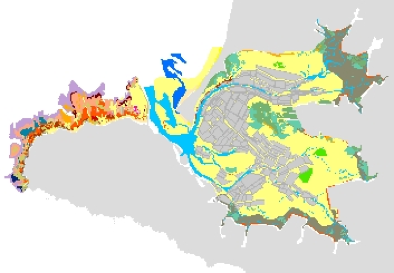
Cartographie des habitats benthiques du secteur du Croisic (REBENT, 2005)
This comprehensive map of the benthic communities of Le Croisic is realized as part of the REBENT programme, i.e. the surveying network for the benthic fauna and flora. It is the result of the treatment, the analysis and the data aggregation from authors and multiple specialized agencies :
- ORTHOLITTORALE 2000,
- IGN data of 2000
- TOTAL FINA ELF, Pays de la Loire Region and IFREMER data of 2002,
- REBENT data from 2002 to 2004,
- C. Bonnot-Courtois, J. Fournier, from the CNRS and C. Rollet, J. Populus, B. Guillaumont, R. Loarer, from Ifremer in 2005.
The communities' qualification is made at the level 4 of the EUNIS classification, excepted when the simple field survey allows qualifying exactly the characteristic species to the level 5.
The original legend is transferred to the "ORIG_HAB" attribute data field.
The harmonization with the EUNIS typology was made in 2006, as part of the REBENT and Interreg-MESH programmes.
Simple
- Alternate title
-
FR000026
- Date (Publication)
- 2006-05-01
- Edition date
- 2006-05-01
- Citation identifier
- FRE-330-715-368-00032-RBT_THM_LE_CROISIC_P
- Purpose
-
Research
- Credit
-
Coastal orthophotography of the Croisic and Pen B├® areas (format .ecw) 2000 ORTHOLITTORALE 2000 ; Photos of the Croisic area, 2000, IGN : digitized, enhanced and geo-referenced by Ifremer / Dyneco / Vigies (format .ecw) TOTAL FINA ELF, Pays de la Loire R├®gion IFREMER, Lidar Altimetry for the Croisic and Pen B├® areas (format .ecw), attached key (image field .emf), 2002, convention 02/1214363/DF ; REBENT, Location of sampling and observation points in Croisic area during the Rebent field studies, September 2002 to March 2004 ; Planche 4 "Cartographie bio-morpho-s├®dimentaire de l'estran meuble du Croisic", in Bonnot-Courtois C., Fournier J., Rollet C., Populus J., Guillaumont B., Loarer R., 2005, Cartographie bio-morpho-s├®dimentaire des estrans dans le cadre du r├®seau benthique (compl├®mentarit├® des orthophotographies littorales et des donn├®es Lidar). Photo-interpr├®tation, n┬░2005/2, p. 13-39.
- Point of contact
-
Organisation name Individual name Electronic mail address Role REBENT Ifremer-EPHE/CNRS-CEVA
Unknown
Point of contact
-
title
-
-
Communities
-
-
title
-
-
23E7
-
- Place
-
-
Bay of Biscay
-
France
-
- Theme
-
-
Rebent
-
- Use limitation
-
This product was elaborated within the framework of REBENT, the French monitoring network for benthic flora and fauna, which associates partners belonging to various organizations. The coordination of the REBENT is carried out by Ifremer. This REBENT product was created in partnership between Ifremer and the Roscoff Biological Centre, the EPHE Geomorphology and Coastal Environment Laboratory of Dinard (PRODIG), the European Research Center for Algae of Pleubian (CEVA) at the origin of the data source. Before any use, read the charter governing the users rights ( http://www.rebent.org/fr/cartes-interactives/conditions-d-utilisation.php?g_url=/docs/data/ifr_peupl_glemarec_large_bzh_p.zip). These files are intended for personal use. Any commercial use of these data is strictly prohibited. For any use other than personal, please contact the custodian Mr. Bellouis. Any modification of these data is subjected to a preliminary authorization. For that please contact B. Guillaumont, person in charge of REBENT project.
- Spatial representation type
- Vector
- Denominator
- 10000
- Character set
- UTF8
- Topic category
-
- Oceans
- Begin date
- 2002-09-01
- End date
- 2004-03-31
))
- Reference system identifier
- GCS_WGS_1984
Distributor
- Distributor contact
-
Organisation name Individual name Electronic mail address Role IFREMER| digital data custodian, D├®partement Informatique et Donn├®es Marines, SISMER, Plouzan├® D├®partement Informatique et Donn├®es Marines, SISMER
Michel BELLOUIS
Point of contact
- Distributor format
-
Name Version Unknown
Unknown
- OnLine resource
-
Protocol Linkage Name WWW:LINK-1.0-http--link
http://www.ifremer.fr/sextant/fr/web/guest/geoviewer?url=http://www.rebent.org/docs/data/Rebent_carto/SecteurCroisic2010_context.xml WWW:LINK-1.0-http--link
http://www.rebent.org/cartographie/ WWW:LINK-1.0-http--link
http://www.rebent.org/fr/documentation/conditions-d-utilisation-des-documents.php WWW:LINK-1.0-http--link
http://www.rebent.org/docs/metadata/04_HabitatsSecteursReferenceBretagne/019_SecteurCroisic/StructureDetailleeTableAttributaire_Ifr_HabitatsBenthiques_Rebent2010_LeCroisic_l2_p.pdf WWW:LINK-1.0-http--link
http://www.rebent.org/docs/metadata/04_HabitatsSecteursReferenceBretagne/019_SecteurCroisic/QualiteCarto_Croisic_ConfidenceScoresheet_Final.pdf
- Hierarchy level
- Dataset
Conceptual consistency
- Name of measure
-
MESH Confidence Assessment
- Measure description
-
https://www.emodnet-seabedhabitats.eu/resources/mesh-archive/
Quantitative attribute accuracy
- Name of measure
-
RemoteTechnique
- Evaluation method description
-
An assessment of whether the remote techniques used to produce this map were appropriate to the environment they were used to survey: 3 = technique(s) highly appropriate 2 = technique(s) moderately appropriate 1 = technique(s) inappropriate
Completeness commission
- Name of measure
-
RemoteCoverage
- Evaluation method description
-
An assessment of the coverage of the remote sensing data including consideration of heterogeneity of the seabed: (See Coverage X Heterogeneity matrix below) Coverage scores - use these to determine coverage then combine with heterogeneity assessment to derive finale scores 3 = good coverage; 100% (or greater) coverage or AGDS track spacing <50m 2 = moderate coverage; swath approx 50% coverage or AGDS track spacing >100m 1 = poor coverage; large gaps between swaths or AGDS track spacing > 100m Final scores 3 = good coverage OR moderate coverage + low heterogeneity 2 = moderate coverage + moderate heterogeneity OR poor coverage + low heterogeneity 1 = moderate coverage + high heterogeneity OR poor coverage + moderate or high heterogeneity
Relative internal positional accuracy
- Name of measure
-
RemotePositioning
- Evaluation method description
-
An indication of the positioning method used for the remote data: 3 = differential GPS 2 = GPS (not differential) or other non-satellite 'electronic' navigation system 1 = chart based navigation, or dead-reckoning
Topological consistency
- Name of measure
-
RemoteStdsApplied
- Evaluation method description
-
An assessment of whether standards have been applied to the collection of the remote data. This field gives an indication of whether some data quality control has been carried out: 3 = remote data collected to approved standards 2 = remote data collected to ?internal? standards 1 = no standards applied to the collection of the remote data
Temporal validity
- Name of measure
-
RemoteVintage
- Evaluation method description
-
An indication of the age of the remote data: 3 = < 5yrs old. 2 = 5 to 10 yrs old. 1 = > 10 years old
Non quantitative attribute accuracy
- Name of measure
-
BGTTechnique
- Evaluation method description
-
An assessment of whether the ground-truthing techniques used to produce this map were appropriate to the environment they were used to survey. Use scores for soft or hard substrata as appropriate to the area surveyed. Soft substrata predominate (i.e. those having infauna and epifauna) 3 = infauna AND epifauna sampled AND observed (video/stills, direct human observation) 2= infauna AND epifauna sampled, but NOT observed (video/stills, direct human observation) 1 = infauna OR epifauna sampled, but not both. No observation. Hard substrata predominate (i.e. those with no infauna) 3 = sampling included direct human observation (shore survey or diver survey) 2 = sampling included video or stills but NO direct human observation 1 = benthic sampling only (e.g. grabs, trawls)
Non quantitative attribute accuracy
- Name of measure
-
PGTTechnique
- Evaluation method description
-
An assessment of whether the combination of geophysical sampling techniques were appropriate to the environment they were used to survey. Use scores for soft or hard substrata as appropriate to the area surveyed. Soft substrata predominate (i.e. gravel, sand, mud) 3 = full geophysical analysis (i.e. granulometry and/or geophysical testing (penetrometry, shear strenght etc)) 2 = sediments described following visual inspection of grab or core samples (e.g. slightly shelly, muddy sand) 1 = sediments described on the basis of remote observation (by camera). Hard substrata predominate (i.e. rock outcrops, boulders, cobbles) 3 = sampling included in-situ, direct human observation (shore survey or diver survey) 2 = sampling included video or photographic observation, but NO in-situ, direct human observation 1 = samples obtained only by rock dredge (or similar)
Relative internal positional accuracy
- Name of measure
-
GTPositioning
- Evaluation method description
-
An indication of the positioning method used for the ground-truth data: 3 = differential GPS 2 = GPS (not differential) or other non-satellite 'electronic' navigation system 1 = chart based navigation, or dead-reckoning
Completeness commission
- Name of measure
-
GTDensity
- Evaluation method description
-
An assessment of what proportion of the polygons or classes (groups of polygons with the same ?habitat? attribute) actually contain ground-truth data: 3 = Every class in the map classification was sampled at least 3 times 2 = Every class in the map classification was sampled 1 = Not all classes in the map classification were sampled (some classes have no ground-truth data)
Conceptual consistency
- Name of measure
-
GTStdsApplied
- Evaluation method description
-
An assessment of whether standards have been applied to the collection of the ground-truth data. This field gives an indication of whether some data quality control has been carried out: 3 = ground-truth samples collected to approved standards 2 = ground-truth samples collected to 'internal' standards 1 = no standards applied to the collection of ground-truth samples
Temporal validity
- Name of measure
-
GTVintage
- Evaluation method description
-
An indication of the age of the ground-truth data: 3 = < 5 yrs old 2 = 5 to 10 yrs old 1 = > 10 years old
Topological consistency
- Name of measure
-
GTInterpretation
- Evaluation method description
-
An indication of the confidence in the biological interpretation of the ground-truthing data: 3 = Evidence of expert interpretation; full descriptions and taxon list provided for each habitat class 2 = Evidence of expert interpretation, but no detailed description or taxon list supplied for each habitat class 1 = No evidence of expert interpretation; limited descriptions available
Completeness commission
- Name of measure
-
RemoteInterpretation
- Evaluation method description
-
An indication of the confidence in the interpretation of the remotely sensed data: 3 = Appropriate technique used and documentation provided 2 = Appropriate technique used but no documentation provided 1 = Inappropriate technique used Note that interpretation techniques can range from ?by eye? digitising of side scan by experts to statistical classification techniques.
Completeness commission
- Name of measure
-
DetailLevel
- Evaluation method description
-
The level of detail to which the 'habitat' classes in the map have been classified: 3 = Classes defined on the basis of detailed biological analysis 2 = Classes defined on the basis of major characterising species or lifeforms 1 = Classes defined on the basis of physical information, or broad biological zones
Thematic classification correctness
- Name of measure
-
MapAccuracy
- Evaluation method description
-
A test of the accuracy of the map: 3 = high accuracy, proven by external accuracy assessment 2 = high accuracy, proven by internal accuracy assessment 1 = low accuracy, proved by either external or internal assessment OR no accuracy assessment made
Domain consistency
- Name of measure
-
Remote
Domain consistency
- Name of measure
-
GT
Domain consistency
- Name of measure
-
Interpretation
- Statement
-
Survey technique(s): Particle size analysis ; Aerial photography ; LIDAR ; Intertidal survey ; Other
- Description
-
Classification scheme: EUNIS
- Description
-
Classification scheme details: EUNIS classification : A1.11 : [Mytilus edulis] and/or barnacle communities A1.11+A1.16FR01 : [Mytilus edulis] and/or barnacle communities + Ostreidae and/or barnacle communities A1.16_FR01 : Proposed EUNIS habitat type: Ostreidae and/or barnacle communities A1.214 : [Fucus serratus] on moderately exposed lower eulittoral rock A1.2141 : [Fucus serratus] and red seaweeds on moderately exposed lower eulittoral rock A1.31 : Fucoids on sheltered marine shores; more details in attribute table (TRAN_COM field) A1.311 : [Pelvetia canaliculata] on sheltered littoral fringe rock A1.313 : [Fucus vesiculosus] on moderately exposed to sheltered mid eulittoral rock A1.314 : [Ascophyllum nodosum] on very sheltered mid eulittoral rock A2.11 : Shingle (pebble) and gravel shores A2.111 : Barren littoral shingle A2.112 : [Pecterogammarus planicrurus] in mid shore well-sorted gravel or coarse sand A2.21 : Strandline A2.22 : Barren or amphipod-dominated mobile sand shores A2.23 : Polychaete et amphipod-dominated fine sand shores A2.24 : Polychaete / bivalve dominated muddy sand shores A2.31 : Polychaete / bivalve - dominated mid estuarine mud shores A2.42 : Species-rich mixed sediment shores A2.516 : [Suaeda vera] saltmarsh driftlines A2.531 : EUNIS category to be clarified : [Halimione] sp. mid-upper saltmarshes A2.548 : EUNIS category to be clarified : Mosaiced low-mid saltmarshes A2.549_FR01 : Proposed EUNIS habitat type: [Spartina] sp. low saltmarshes A2.5513 : [Salicornia] spp. pioneer saltmarshes A2.5543 : [Spartina maritima] pioneer saltmarshes A2.6111 : [Zostera noltii] beds in littoral muddy sand A2.711 : [Sabellaria alveolata] reefs on sand-abraded eulittoral rock A2.7211 : [Mytilus edulis] beds on littoral mixed substrata A2.88_FR01 : Proposed EUNIS habitat type: Features of littoral sediment, Habitat under human influence A3.2 : Atlantic and Mediterranean moderate energy infralittoral rock B1.3_FR01 : Proposed EUNIS habitat type: Shifting coastal dunes (back of the dune) B1.31 : Shifting coastal dunes
- Description
-
Survey technique details: * Scientific partners : Several laboratories are involved in the studies carried out within the REBENT project framework. External experts who are not part of Ifremer contribute to our understanding of the milieu once the fields surveys have been set up. Resolution of data : < 1 metre Spatial accuracy of coordinates : Accurate to within 10m * Survey method comment : - To monitor the intertidal zone, coastal orthophotographs, altimetric data from LIDAR readings and reference data from the SHOM (coastline tracing and rocky contours from the BDPS of 1/10000) were initially available. - On analysing these data, it was possible to identify primarily the main structures of relatively homogeneous zones. From this initial interpretation, checks could then be carried out in the field. Each event (sampling of sediment, fauna, flora, photo, field notes) was linked to a geographical position (X or Y). All the REBENT data were geo-referenced. The acquisition, management and use of data focus around this spatial element. 4 field studies (Ri for intertidal REBENT) were carried out in the area Ri_001 in September 2002, Ri_002 in May 2003, Ri_006 in November 2003 and Ri_001 in March 2004. - The diverse nature of the data compiled in the field has led to the existence of a number of files of different quality and format : field notes, photos, analysis results? The missing information is gradually added as the analyses are completed and the data treated. In order to provide rapid and easy access, all is managed within one data base (concept ESRI) (Steven Piel 2004) - a data base system with a spatial reference. - By analysing the results and including all the available data, it is possible to produce morpho-sedimentary mapping, which is a precondition to the setting up of benthic habitat mapping. - The final mapping is based on information extracted from coastal orthophotographs and validated through field checks, then associated with supplementary data like sedimentary facies, the LIDAR, the bathymetry and the means of exposure. - The upper limit of the middle shore is extracted from LIDAR data and corresponds to the exceptional high water spring-tide index in the Croisic port (615 cm). - See also : Rollet, C., Bonnot-Courtois C., Fournier J., September 2005. FT013 - Cartographie des habitats benthiques en zone intertidale à partir des orthophotographies littorales, 18 p. + 2 Fiches outils ( http://www.rebent.org/, rubrique Documentation, sous-rubrique Fiches techniques).
- Processor
-
Organisation name Individual name Electronic mail address Role Benthologist from the Biological Centre at Roscoff or from the IUEM (UBO); Geomorphologist from the Geomorphology and Coastal Environment Laboratory of Dinard (PRODIG); the European Research Center for Algae (CEVA) handles the demarcation of algal bands;
Benthologist from the Biological Centre at Roscoff or from the IUEM (UBO); Geomorphologist from the Geomorphology and Coastal Environment Laboratory of Dinard (PRODIG); the European Research Center for Algae (CEVA) handles the demarcation of algal bands;
Principal investigator
- Description
-
Mapping method: Interpolated point data; Interpolated track data; Created by combining datasets; Expert judgement; Mapped directly; Supervised classification
Metadata
- File identifier
- d6cb90bb-0968-4071-96e2-18839658bffc XML
- Character set
- UTF8
- Date stamp
- 2022-02-24T15:03:10
- Metadata standard name
-
ISO 19115:2003/19139
- Metadata standard version
-
1.0
- Metadata author
-
Organisation name Individual name Electronic mail address Role REBENT Ifremer-EPHE/CNRS-CEVA
Unknown
Point of contact
Overviews

Spatial extent
Provided by
