 ICES Metadata Catalogue
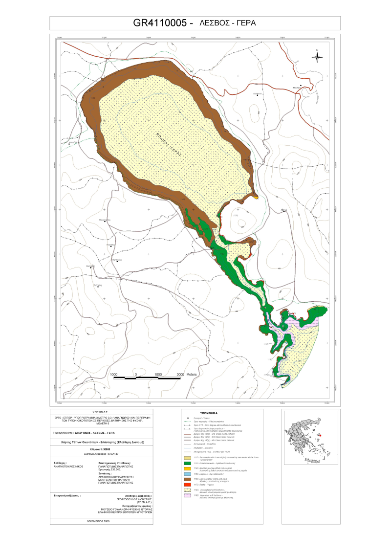
Marine habitat mapping within the GR4110005 Natura site (Lesvos: Kolpos Geras, Elos Ntipi kai Oros Olympos)
The description and mapping of marine habitat types according to Annex I of Directive 92/43/EOK (EEC, 1992) and / or the European Nature Information System (EUNIS) in 66 of approximately 300 Greek NATURA 2000 network sites, were the subject of Research Work for the Ministry of Environment Planning and Public Works of Greece. This research project, under the name "Identification and description of habitat types at sites of interest for conservation", lasted from 1999 to 2002 and was carried out by the National Centre for Marine Research (NCMR, renamed as Hellenic Centre for Marine Research - HCMR since 2003) in association with the Institute of Marine Biology of Crete (IBCM, joined to HCMR since 2003), the Aristotle University of Thessaloniki and the Fisheries Research Institute (FRI). The recognition and imprinting of marine habitat types was based on the combined use of aerial photos of scale 1:5000 acquired during the second half of 1999 for the needs of the project, data from the scientific echo sounder Sea-Bed discrimination system "RoxAnn", phytobenthos samples and in situ observations by scuba diving and underwater cameras. Regarding the sampling, hard bottom samplings were carried out using SCUBA diving. The samples were collected on hard substrates mainly in the upper infralittoral zone (30 to 50 cm below the lowest sea level). For the study of the soft bottom habitats, oceanographic cruses were carried out with the IMBC R/V ÔÇ£FiliaÔÇØ, using a Smith McIntyre sediment sampler.
Simple
- Alternate title
-
GR000036
- Date (Publication)
- 2001-07-01T00:00:00
- Presentation form
- Digital map
- Purpose
-
Nature conservation, Research, Marine environment
- Status
- Completed
- Point of contact
-
Organisation name Individual name Electronic mail address Role Hellenic Centre for Marine Research
Panayotis Panayotidis
Principal investigator
- Maintenance and update frequency
- Not planned
- Theme
-
-
Marine habitat mapping
-
Protected sites
-
-
GEMET - INSPIRE themes, version 1.0
-
-
Habitats and biotopes
-
- Use limitation
-
Data is available upon request. Any modification of these data is subject to preliminary authorization. Please contact the person in charge
- Access constraints
- Copyright
- Use constraints
- Copyright
- Other constraints
-
Reference citation is required in the bibliography
- Spatial representation type
- Vector
- Denominator
- 10000
- Language
-
eng
- Character set
- UTF8
- Topic category
-
- Environment
))
Vertical extent
- Minimum value
- 0
- Maximum value
- -50
- Reference system identifier
- WGS 1984
- Distribution format
-
Name Version Esri Shapefile ESRI ArcGIS 10.4
- OnLine resource
-
Protocol Linkage Name OGC:WMS-1.1.1-http-get-map
OGC:WMS
https://ows.emodnet-seabedhabitats.eu/geoserver/emodnet_view_maplibrary/wms? gr000036
OGC:WFS
https://ows.emodnet-seabedhabitats.eu/geoserver/emodnet_open_maplibrary/wfs? gr000036
WWW:LINK-1.0-http--link
ttps://www.emodnet-seabedhabitats.eu/access-data/download-data/?gui=gr000036 EMODnet Seabed Habitats download page - map preselected
WWW:LINK-1.0-http--link
https://files.emodnet-seabedhabitats.eu/data/EMODnetSBHsurvey_GR000036.zip EMODnet Seabed Habitats download
- Hierarchy level
- Dataset
Conformance result
- Date
- 2001-07-01
- Pass
- No
Conformance result
- Date (Publication)
- Pass
Metadata
- File identifier
- c5e282c9-3fc0-4dfc-bbc8-700b4da7a922 XML
- Metadata language
-
eng
- Character set
- UTF8
- Date stamp
- 2026-03-11T09:24:20.8510192Z
- Metadata standard name
-
ISO 19115:2003/19139
- Metadata standard version
-
1.0
- Metadata author
-
Organisation name Individual name Electronic mail address Role Hellenic National Oceanographic Data Centre
Sissy Iona
Point of contact

)))