 ICES Metadata Catalogue
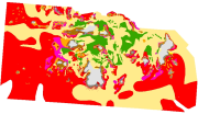
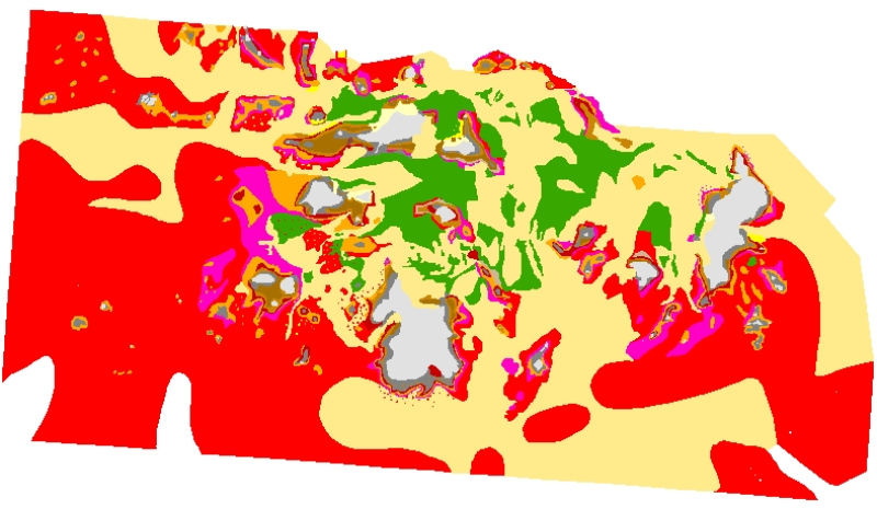
Carte de la végétation marine autour de l’Archipel des Glénan (Source Arzel P., 1985)
This comprehensive map of the benthic communities of Les Glénan, is the synthesis of studies introduced by R. Pérez, from ISTPM, in 1980, to localize new fields of algae in front of increasing needs of the industry. It was finalized by P. Arzel, from Ifremer, in March and April 1985.
For these studies, different methods were used: underwater diving, tidal zone photographs, field surveys.
The aim of this study was to inform the CIAM (Comité Interprofessionnel des Algues Marines = Interprofessional committee of Seaweeds ) of evaluation of the resources and the potentialities of the Glenan. Elements collected in this layer correspond to the state of the knowledge in 1985.
This map was digitised in 2006, as part of the REBENT programme, i.e. the surveying network for the benthic fauna and flora. The original legend is transferred to the "LEG_ORIG" attribute data field. The harmonization with the EUNIS typology is in progress, as part of the REBENT and Interreg-MESH programmes.
One extra layer must be associated with this set of data: a point data layer on Cystoseira sp. et Halidrys siliquosa.
Simple
- Alternate title
-
FR000029
- Alternate title
-
ifr_vegetation_Arzel1985_Glenan_wgs84_p
- Date (Publication)
- 2006-10-01
- Edition date
- 2006-10-01
- Purpose
-
Research
- Credit
-
R. Pérez, 1980-1985, Cartographie des champs d'algues de Bretagne (Not published data) ; P. Arzel, 1986, Les ressources végétales marines des Iles Glénan, Ifremer report, 4 p.-appendice
- Point of contact
-
Organisation name Individual name Electronic mail address Role REBENT Ifremer
Unknown
Point of contact
-
title
-
-
Communities
-
-
title
-
-
24E5; 24E6
-
- Place
-
-
Bay of Biscay
-
France
-
- Theme
-
-
Rebent
-
- Use limitation
-
This product was elaborated within the framework of REBENT, the French monitoring network for benthic flora and fauna, which associates partners belonging to various organizations. The coordination of the REBENT is carried out by Ifremer. This REBENT product was created by Ifremer at the origin of the data source. Before any use, read the charter governing the users rights ( http://www.rebent.org/fr/cartes-interactives/). These files are intended for personal use. Any commercial use of these data is strictly prohibited. For any use other than personal, please contact the custodian Mr. Bellouis. Any modification of these data is subjected to a preliminary authorization. For that please contact B. Guillaumont, person in charge of REBENT project
- Spatial representation type
- Vector
- Denominator
- 10000
- Character set
- UTF8
- Topic category
-
- Oceans
- Begin date
- 1980-01-01
- End date
- 1985-04-09
))
- Reference system identifier
- GCS_WGS_1984
Distributor
- Distributor contact
-
Organisation name Individual name Electronic mail address Role IFREMER| digital data custodian, Département Informatique et Données Marines, SISMER, Plouzané Département Informatique et Données Marines, SISMER
Michel BELLOUIS
Point of contact
- Distributor format
-
Name Version Unknown
Unknown
- OnLine resource
-
Protocol Linkage Name WWW:LINK-1.0-http--link
http://www.ifremer.fr/sextant/fr/web/guest/geoviewer?url=http://www.rebent.org/docs/data/Rebent_carto/AlguesArchipelGlenan1985_context.xml
- Hierarchy level
- Dataset
Conceptual consistency
- Name of measure
-
MESH Confidence Assessment
- Measure description
-
https://www.emodnet-seabedhabitats.eu/resources/mesh-archive/
Quantitative attribute accuracy
- Name of measure
-
RemoteTechnique
- Evaluation method description
-
An assessment of whether the remote techniques used to produce this map were appropriate to the environment they were used to survey: 3 = technique(s) highly appropriate 2 = technique(s) moderately appropriate 1 = technique(s) inappropriate
Completeness commission
- Name of measure
-
RemoteCoverage
- Evaluation method description
-
An assessment of the coverage of the remote sensing data including consideration of heterogeneity of the seabed: (See Coverage X Heterogeneity matrix below) Coverage scores - use these to determine coverage then combine with heterogeneity assessment to derive finale scores 3 = good coverage; 100% (or greater) coverage or AGDS track spacing <50m 2 = moderate coverage; swath approx 50% coverage or AGDS track spacing >100m 1 = poor coverage; large gaps between swaths or AGDS track spacing > 100m Final scores 3 = good coverage OR moderate coverage + low heterogeneity 2 = moderate coverage + moderate heterogeneity OR poor coverage + low heterogeneity 1 = moderate coverage + high heterogeneity OR poor coverage + moderate or high heterogeneity
Relative internal positional accuracy
- Name of measure
-
RemotePositioning
- Evaluation method description
-
An indication of the positioning method used for the remote data: 3 = differential GPS 2 = GPS (not differential) or other non-satellite 'electronic' navigation system 1 = chart based navigation, or dead-reckoning
Topological consistency
- Name of measure
-
RemoteStdsApplied
- Evaluation method description
-
An assessment of whether standards have been applied to the collection of the remote data. This field gives an indication of whether some data quality control has been carried out: 3 = remote data collected to approved standards 2 = remote data collected to ?internal? standards 1 = no standards applied to the collection of the remote data
Temporal validity
- Name of measure
-
RemoteVintage
- Evaluation method description
-
An indication of the age of the remote data: 3 = < 5yrs old. 2 = 5 to 10 yrs old. 1 = > 10 years old
Non quantitative attribute accuracy
- Name of measure
-
BGTTechnique
- Evaluation method description
-
An assessment of whether the ground-truthing techniques used to produce this map were appropriate to the environment they were used to survey. Use scores for soft or hard substrata as appropriate to the area surveyed. Soft substrata predominate (i.e. those having infauna and epifauna) 3 = infauna AND epifauna sampled AND observed (video/stills, direct human observation) 2= infauna AND epifauna sampled, but NOT observed (video/stills, direct human observation) 1 = infauna OR epifauna sampled, but not both. No observation. Hard substrata predominate (i.e. those with no infauna) 3 = sampling included direct human observation (shore survey or diver survey) 2 = sampling included video or stills but NO direct human observation 1 = benthic sampling only (e.g. grabs, trawls)
Non quantitative attribute accuracy
- Name of measure
-
PGTTechnique
- Evaluation method description
-
An assessment of whether the combination of geophysical sampling techniques were appropriate to the environment they were used to survey. Use scores for soft or hard substrata as appropriate to the area surveyed. Soft substrata predominate (i.e. gravel, sand, mud) 3 = full geophysical analysis (i.e. granulometry and/or geophysical testing (penetrometry, shear strenght etc)) 2 = sediments described following visual inspection of grab or core samples (e.g. slightly shelly, muddy sand) 1 = sediments described on the basis of remote observation (by camera). Hard substrata predominate (i.e. rock outcrops, boulders, cobbles) 3 = sampling included in-situ, direct human observation (shore survey or diver survey) 2 = sampling included video or photographic observation, but NO in-situ, direct human observation 1 = samples obtained only by rock dredge (or similar)
Relative internal positional accuracy
- Name of measure
-
GTPositioning
- Evaluation method description
-
An indication of the positioning method used for the ground-truth data: 3 = differential GPS 2 = GPS (not differential) or other non-satellite 'electronic' navigation system 1 = chart based navigation, or dead-reckoning
Completeness commission
- Name of measure
-
GTDensity
- Evaluation method description
-
An assessment of what proportion of the polygons or classes (groups of polygons with the same ?habitat? attribute) actually contain ground-truth data: 3 = Every class in the map classification was sampled at least 3 times 2 = Every class in the map classification was sampled 1 = Not all classes in the map classification were sampled (some classes have no ground-truth data)
Conceptual consistency
- Name of measure
-
GTStdsApplied
- Evaluation method description
-
An assessment of whether standards have been applied to the collection of the ground-truth data. This field gives an indication of whether some data quality control has been carried out: 3 = ground-truth samples collected to approved standards 2 = ground-truth samples collected to 'internal' standards 1 = no standards applied to the collection of ground-truth samples
Temporal validity
- Name of measure
-
GTVintage
- Evaluation method description
-
An indication of the age of the ground-truth data: 3 = < 5 yrs old 2 = 5 to 10 yrs old 1 = > 10 years old
Topological consistency
- Name of measure
-
GTInterpretation
- Evaluation method description
-
An indication of the confidence in the biological interpretation of the ground-truthing data: 3 = Evidence of expert interpretation; full descriptions and taxon list provided for each habitat class 2 = Evidence of expert interpretation, but no detailed description or taxon list supplied for each habitat class 1 = No evidence of expert interpretation; limited descriptions available
Completeness commission
- Name of measure
-
RemoteInterpretation
- Evaluation method description
-
An indication of the confidence in the interpretation of the remotely sensed data: 3 = Appropriate technique used and documentation provided 2 = Appropriate technique used but no documentation provided 1 = Inappropriate technique used Note that interpretation techniques can range from ?by eye? digitising of side scan by experts to statistical classification techniques.
Completeness commission
- Name of measure
-
DetailLevel
- Evaluation method description
-
The level of detail to which the 'habitat' classes in the map have been classified: 3 = Classes defined on the basis of detailed biological analysis 2 = Classes defined on the basis of major characterising species or lifeforms 1 = Classes defined on the basis of physical information, or broad biological zones
Thematic classification correctness
- Name of measure
-
MapAccuracy
- Evaluation method description
-
A test of the accuracy of the map: 3 = high accuracy, proven by external accuracy assessment 2 = high accuracy, proven by internal accuracy assessment 1 = low accuracy, proved by either external or internal assessment OR no accuracy assessment made
Domain consistency
- Name of measure
-
Remote
Domain consistency
- Name of measure
-
GT
Domain consistency
- Name of measure
-
Interpretation
- Statement
-
Survey technique(s): Aerial photography ; Diver survey ; Intertidal survey
- Description
-
Classification scheme: Local
- Description
-
Classification scheme details: Local classification : - Supra littoral rocheux ; - Galets ; - Sédiments meubles ; - Supra littoral sableux ; - Zostera marina ; - Fucus sp. ; - Bifurcaria bifurcata + Himanthalia elongata (algae belt subject to annual variation) ; - Ascophyllum nodosum ; - Laminaria digitata ; - Laminaria hyperborea ; - Laminaria ochroleuca ; - Laminaria saccharina ; - Sacchorhiza polyschides (algae belt subject to annual variation). The harmonization with the EUNIS typology is in progress, as part of the REBENT and Interreg-MESH programmes.
- Description
-
Survey technique details: * Survey method : - The missions led by René Pérez, began in 1980. The recognition of the Laminaires by dives was privileged. The boat support was Zodiac. The observations were recorded on a SHOM nautical map at the scale of 1/10000. - Pierre Arzel privileged intertidals communities : Field observations were preceded by a reconnaissance flight, realized on February 22, 1985, at the time of the bass-sea (11:39 am), by a tide coefficient of 86. The height of aerial photographs was situated in 250 metres and the weather was excellent. There were 110 oblique photographs of tidal zones. Photographs were Kodachrome colour transparencies. The two first films were made with a lens of 50 mm ; the third film was made with a telephoto lens. Field surveys were carried out between 6 and 11 March 1985 and between 4 and 9 April 1985, during the tides with a coefficient superior to 90. The observations were recorded on nautical map at the scale of 1/10000. Algae belts were positioned thanks to landmarks and remarkable alignments, directly on the map. The deep populations were the object of observations by dives or by use of the system of the magnifying glass of calfat, usage made possible the depth is weak. The nature of the populations was noted as one goes along by the observer, who drifted. In case of doubt on the determination of laminariales, a special tool to collect kelps, allowed to return the necessary samples for a diagnosis. The aim of this study was to inform the CIAM (Comité Interprofessionnel des Algues Marines = Interprofessional committee of Seaweeds ) on the potentialities of the Glenan (letter of 26 December 1984). That's why the accent was put on the qualification and the quantification of commercial usage stocks, that is Fucales, Laminariales and in a lesser measure Gigartinales. * Digitized methodology (coordinated by IFREMER DYNECO/VIGIES Brest B. Guillaumont et Chantal Croguennec, BETI subcontractor) : several operations were necessary to get a digital information medium (from paper documents) : - Paper map was scanned at a 400 dpi resolution; - The scanned files were georeferenced, using "ArcView" software, version 8.3 ; - Digitizing was ArcView-based, using a large scale display (scale 10 times larger than the original document) ; - For each polygon, the original legend (ORIG_HAB) was indicated in an attribute date field. The coastline used is that of Ifremer-Shom (scale = 1/25000) (date of revision 1995). The harmonization with the EUNIS typology is in progress, as part of the REBENT and Interreg-MESH programmes.
- Processor
-
Organisation name Individual name Electronic mail address Role Pérez, R.; Arzel, P.
Pérez, R.; Arzel, P.
Principal investigator
- Description
-
Mapping method: Expert judgement; Mapped directly; Unsupervised classification
Metadata
- File identifier
- b35234e5-3428-4186-a2dd-5d674798211a XML
- Character set
- UTF8
- Date stamp
- 2022-02-24T15:02:54
- Metadata standard name
-
ISO 19115:2003/19139
- Metadata standard version
-
1.0
- Metadata author
-
Organisation name Individual name Electronic mail address Role REBENT Ifremer
Unknown
Point of contact
Overviews
Spatial extent
Provided by
