 ICES Metadata Catalogue
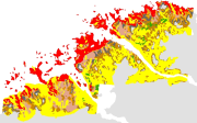
Carte de la v├®g├®tation marine c├┤ti├¿re, Aber Wrac'h - Aber Beno├«t (Finist├¿re-Nord) (1987) au 1/20000
This map of the coastal marine vegetation, in the Aber Wrac'h and Aber Beno├«t (North Brittany), is copy out from the "PEPS VEGMA Cartographie de la v├®g├®tation marine c├┤ti├¿re sur le littoral bas-l├®onard (Finist├¿re Nord)" by J. Y. Piriou from Ifremer, published in 1987. It was realized as part of the "Projet d'Evaluation Pr├®liminaire Spot - VEG├®taux MArins".
The objective was to define the contribution of the SPOT satellite in the cartography of the phytobenthos in coastal environment (intertidal and subtidal zone) in particular on Fucales and Laminariales.
These map was digitized in 2004, as part of the REBENT programme, i.e. the surveying network for the benthic fauna and flora. The original legend is transferred to the "ORIG_HAB" attribute data field. The harmonization with the EUNIS typology is in progress, as part of the REBENT and Interreg-MESH programmes.
Simple
- Alternate title
-
FR000012
- Alternate title
-
ifr_vegetation_Piriou_AbersWrachBenoit_wgs84_p
- Date (Publication)
- 2004-06-01
- Edition date
- 2004-06-01
- Purpose
-
Research
- Credit
-
Piriou, J. Y. et al., 1987, PEPS VEGMA Cartographie de la v├®g├®tation marine c├┤ti├¿re sur le littoral bas-l├®onard (Finist├¿re-nord), Ifremer-DERO-87.22-EL
- Point of contact
-
Organisation name Individual name Electronic mail address Role REBENT Ifremer
Unknown
Point of contact
-
title
-
-
Communities
-
-
title
-
-
26E5
-
- Place
-
-
Western Channel; Celtic Sea
-
France
-
- Theme
-
-
Rebent
-
- Use limitation
-
This product was elaborated within the framework of REBENT, the French monitoring network for benthic flora and fauna, which associates partners belonging to various organizations. The coordination of the REBENT is carried out by Ifremer. This REBENT product was created by Ifremer, which is at the origin of the data source. Before any use, read the charter governing the users rights ( http://www.rebent.org/cartographie/index.php). These files are intended for personal use. Any commercial use of these data is strictly prohibited. For any use other than personal, please contact the custodian Mr. Bellouis. Any modification of these data is subjected to a preliminary authorization. For that please contact B. Guillaumont, person in charge of REBENT project.
- Spatial representation type
- Vector
- Denominator
- 20000
- Character set
- UTF8
- Topic category
-
- Oceans
- Begin date
- 1986-05-09
- End date
- 1987-09-30
))
- Reference system identifier
- GCS_WGS_1984
Distributor
- Distributor contact
-
Organisation name Individual name Electronic mail address Role IFREMER| digital data custodian, D├®partement Informatique et Donn├®es Marines, SISMER, Plouzan├® D├®partement Informatique et Donn├®es Marines, SISMER
Michel BELLOUIS
Point of contact
- Distributor format
-
Name Version Unknown
Unknown
- OnLine resource
-
Protocol Linkage Name WWW:LINK-1.0-http--link
http://www.ifremer.fr/sextant/fr/web/guest/geoviewer?url=http://www.rebent.org/docs/data/Rebent_carto/AlguesAbers1987_context.xml
- Hierarchy level
- Dataset
Conceptual consistency
- Name of measure
-
MESH Confidence Assessment
- Measure description
-
https://www.emodnet-seabedhabitats.eu/resources/mesh-archive/
Quantitative attribute accuracy
- Name of measure
-
RemoteTechnique
- Evaluation method description
-
An assessment of whether the remote techniques used to produce this map were appropriate to the environment they were used to survey: 3 = technique(s) highly appropriate 2 = technique(s) moderately appropriate 1 = technique(s) inappropriate
Completeness commission
- Name of measure
-
RemoteCoverage
- Evaluation method description
-
An assessment of the coverage of the remote sensing data including consideration of heterogeneity of the seabed: (See Coverage X Heterogeneity matrix below) Coverage scores - use these to determine coverage then combine with heterogeneity assessment to derive finale scores 3 = good coverage; 100% (or greater) coverage or AGDS track spacing <50m 2 = moderate coverage; swath approx 50% coverage or AGDS track spacing >100m 1 = poor coverage; large gaps between swaths or AGDS track spacing > 100m Final scores 3 = good coverage OR moderate coverage + low heterogeneity 2 = moderate coverage + moderate heterogeneity OR poor coverage + low heterogeneity 1 = moderate coverage + high heterogeneity OR poor coverage + moderate or high heterogeneity
Relative internal positional accuracy
- Name of measure
-
RemotePositioning
- Evaluation method description
-
An indication of the positioning method used for the remote data: 3 = differential GPS 2 = GPS (not differential) or other non-satellite 'electronic' navigation system 1 = chart based navigation, or dead-reckoning
Topological consistency
- Name of measure
-
RemoteStdsApplied
- Evaluation method description
-
An assessment of whether standards have been applied to the collection of the remote data. This field gives an indication of whether some data quality control has been carried out: 3 = remote data collected to approved standards 2 = remote data collected to ?internal? standards 1 = no standards applied to the collection of the remote data
Temporal validity
- Name of measure
-
RemoteVintage
- Evaluation method description
-
An indication of the age of the remote data: 3 = < 5yrs old. 2 = 5 to 10 yrs old. 1 = > 10 years old
Non quantitative attribute accuracy
- Name of measure
-
BGTTechnique
- Evaluation method description
-
An assessment of whether the ground-truthing techniques used to produce this map were appropriate to the environment they were used to survey. Use scores for soft or hard substrata as appropriate to the area surveyed. Soft substrata predominate (i.e. those having infauna and epifauna) 3 = infauna AND epifauna sampled AND observed (video/stills, direct human observation) 2= infauna AND epifauna sampled, but NOT observed (video/stills, direct human observation) 1 = infauna OR epifauna sampled, but not both. No observation. Hard substrata predominate (i.e. those with no infauna) 3 = sampling included direct human observation (shore survey or diver survey) 2 = sampling included video or stills but NO direct human observation 1 = benthic sampling only (e.g. grabs, trawls)
Non quantitative attribute accuracy
- Name of measure
-
PGTTechnique
- Evaluation method description
-
An assessment of whether the combination of geophysical sampling techniques were appropriate to the environment they were used to survey. Use scores for soft or hard substrata as appropriate to the area surveyed. Soft substrata predominate (i.e. gravel, sand, mud) 3 = full geophysical analysis (i.e. granulometry and/or geophysical testing (penetrometry, shear strenght etc)) 2 = sediments described following visual inspection of grab or core samples (e.g. slightly shelly, muddy sand) 1 = sediments described on the basis of remote observation (by camera). Hard substrata predominate (i.e. rock outcrops, boulders, cobbles) 3 = sampling included in-situ, direct human observation (shore survey or diver survey) 2 = sampling included video or photographic observation, but NO in-situ, direct human observation 1 = samples obtained only by rock dredge (or similar)
Relative internal positional accuracy
- Name of measure
-
GTPositioning
- Evaluation method description
-
An indication of the positioning method used for the ground-truth data: 3 = differential GPS 2 = GPS (not differential) or other non-satellite 'electronic' navigation system 1 = chart based navigation, or dead-reckoning
Completeness commission
- Name of measure
-
GTDensity
- Evaluation method description
-
An assessment of what proportion of the polygons or classes (groups of polygons with the same ?habitat? attribute) actually contain ground-truth data: 3 = Every class in the map classification was sampled at least 3 times 2 = Every class in the map classification was sampled 1 = Not all classes in the map classification were sampled (some classes have no ground-truth data)
Conceptual consistency
- Name of measure
-
GTStdsApplied
- Evaluation method description
-
An assessment of whether standards have been applied to the collection of the ground-truth data. This field gives an indication of whether some data quality control has been carried out: 3 = ground-truth samples collected to approved standards 2 = ground-truth samples collected to 'internal' standards 1 = no standards applied to the collection of ground-truth samples
Temporal validity
- Name of measure
-
GTVintage
- Evaluation method description
-
An indication of the age of the ground-truth data: 3 = < 5 yrs old 2 = 5 to 10 yrs old 1 = > 10 years old
Topological consistency
- Name of measure
-
GTInterpretation
- Evaluation method description
-
An indication of the confidence in the biological interpretation of the ground-truthing data: 3 = Evidence of expert interpretation; full descriptions and taxon list provided for each habitat class 2 = Evidence of expert interpretation, but no detailed description or taxon list supplied for each habitat class 1 = No evidence of expert interpretation; limited descriptions available
Completeness commission
- Name of measure
-
RemoteInterpretation
- Evaluation method description
-
An indication of the confidence in the interpretation of the remotely sensed data: 3 = Appropriate technique used and documentation provided 2 = Appropriate technique used but no documentation provided 1 = Inappropriate technique used Note that interpretation techniques can range from ?by eye? digitising of side scan by experts to statistical classification techniques.
Completeness commission
- Name of measure
-
DetailLevel
- Evaluation method description
-
The level of detail to which the 'habitat' classes in the map have been classified: 3 = Classes defined on the basis of detailed biological analysis 2 = Classes defined on the basis of major characterising species or lifeforms 1 = Classes defined on the basis of physical information, or broad biological zones
Thematic classification correctness
- Name of measure
-
MapAccuracy
- Evaluation method description
-
A test of the accuracy of the map: 3 = high accuracy, proven by external accuracy assessment 2 = high accuracy, proven by internal accuracy assessment 1 = low accuracy, proved by either external or internal assessment OR no accuracy assessment made
Domain consistency
- Name of measure
-
Remote
Domain consistency
- Name of measure
-
GT
Domain consistency
- Name of measure
-
Interpretation
- Statement
-
Survey technique(s): Towed video ; Aerial photography ; Satellite imagery ; Intertidal survey
- Description
-
Classification scheme: Local
- Description
-
Classification scheme details: Local classification : Couverture ├á Zostera marina Couverture algale intertidale de moyenne ou forte densit├® - dominante Fucales Couverture dense ├á Laminaria digitata Couverture dense ├á Laminaria hyperborea M├®lange d'esp├¿ces - dominante Laminariales Roche sans v├®g├®tation ou couverture algale intertidale de faible densit├® Sable ou vase sans v├®g├®tation V├®g├®tation terrestre The harmonization with the EUNIS typology is in progress, as part of the REBENT and Interreg-MESH programmes.
- Description
-
Survey technique details: Resolution of data : 1-10 metres Spatial accuracy of coordinates : Accurate to within 10m * Survey method comment : -> Colors aerial photographies : Mission of 05/09/1986, scale 1/10000 : Abers coasts between Plouguerneau and Ploudalm├®zeau ; Mission of 03/12/1986, scale 1/10000 : Portsall ; The negatives have been laid out on a nautical chart at the scale of 1/10000. -> Submarine videos : Mission of 24-25/02/1987 on board the oceanographic vessel Thalia ; Mission on the sector of Aber Wrac'h : 07-08/04/1987, 10/04/1987, 22/04/1987, on the rescue boat of the SNSM ; Mission on the sector of Aber Beno├«t : 24-25/02/1987, 08-10/04/1987, 23-24/04/1987, 19-20/05/1987, on the rescue boat SNSM ; The positioning is determined by the system SYLEDIS SR3, with an accuracy margin of a few metres ; a bathymetric probe determines the water height at any requested moment during the video recording of the sea bed ; the colour camera is towed by the ship. -> SPOT images * Methodology of phytobenthos mapping : -> The intertidal zone is mapped directly from aerial photos and some field surveys. By colouring the aerial shots, it is possible to distinguish 5 different types. The SPOT image helps to differenciate further between the main types of algae (chlorophyceae, brown algae, red algae) as well as to calculate automatically the surface areas covered by each group of algae. -> Concerning the sub-tidal zone, the SPOT image helps define the contours of the sedimentary sectors and draw the expected lay-out of the transects to be carried out using under-water video equipment. The positioning system data gathered during under-water video prospection are transferred on the negatives which include the geographical coordinates corresponding to a scale of 1/20000. In the wake of video image processing, it is possible to determine the percentage coverage for each species and match it to the bathymetric probing data. Subtidal phytobenthos mapping was completed with slight extrapolation, from the SPOT images and transect data. It did not go beyond the bathymetric level of 10 metres. * Digitizing methodology (coordinated by IFREMER DEL/AO, B. Guillaumont / Chantal Croguennec, BETI subcontractor) : several operations were necessary to get a digital information medium (from paper documents) : - Each paper map was scanned at a 400-dpi resolution, - The scanned files were georeferenced, using "ArcView 8.3" software, - Digitizing was ArcView-based, in a shapefile, using a large scale display (scale 10 times larger than the original document). The reference coastline used is the so-called "Ifremer-Shom" on scale 1/25000 (updated in 1995), - For each polygon, the original legend (ORIG_HAB) was indicated in an attribute data field. The harmonization with the EUNIS typology is in progress, as part of the REBENT and Interreg-MESH programmes.
- Processor
-
Organisation name Individual name Electronic mail address Role Piriou, J. Y.
Piriou, J. Y.
Principal investigator
- Description
-
Mapping method: Interpolated point data; Interpolated track data; Expert judgement; Mapped directly; Unsupervised classification
Metadata
- File identifier
- a692ed67-660e-4857-a16a-026986597cda XML
- Character set
- UTF8
- Date stamp
- 2022-09-08T09:12:38.355Z
- Metadata standard name
-
ISO 19115:2003/19139
- Metadata standard version
-
1.0
- Metadata author
-
Organisation name Individual name Electronic mail address Role REBENT Ifremer
Unknown
Point of contact
Overviews

Spatial extent
Provided by
