 ICES Metadata Catalogue
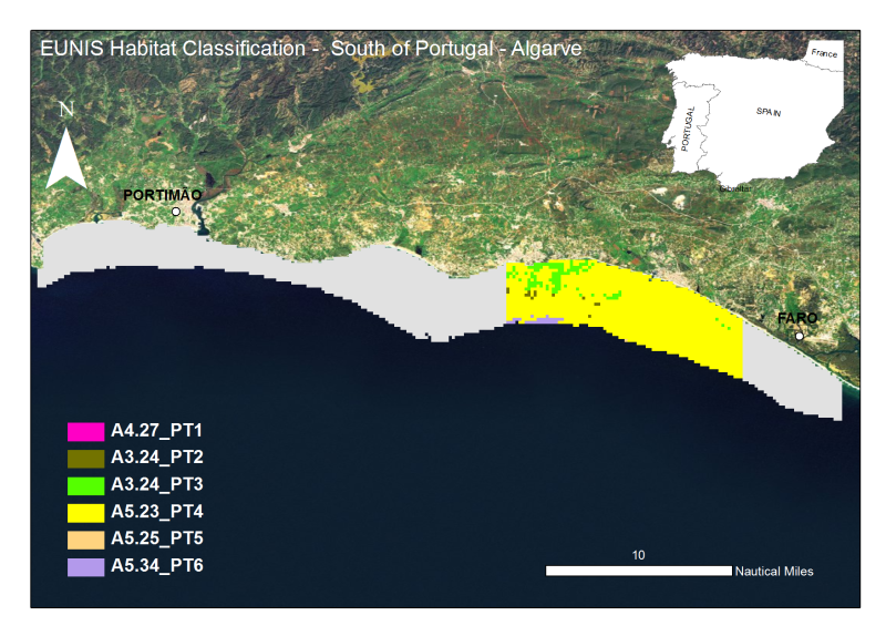
Algarve:Mapping of marine biocenoses off the National Underwater Ecological Reserve between Albufeira and Vale do Lobo - CCMAR-CCDRALG
The Algarve coast presents a significant portion of territory that is part of the designated National Nature Reserve, in its underwater slope (0 to 30m depth - RENSUB), especially when compared with the equivalent on land. The current digital map presents the EUNIS habitat of the central Algarve RENSUB coast. The covered area is between Albufeira and Vale do Lobo. The sediment classification was obtained through the interpretation of data from Side Scan Sonar (remote-sensing image), while for the habitat mapping the biological sampling was carried out with beam trawl and underwater visual census.
Simple
- Alternate title
-
PT000001
- Date (Revision)
- 2010-12-01T00:00:00
- Edition
-
2012
- Presentation form
- Digital map
- Purpose
-
Provide information on the EUNIS Habitat
- Status
- Historical archive
- Point of contact
-
Organisation name Individual name Electronic mail address Role University of Algarve (UAlg-FCT)- Centre of Marine Sciences (CCMAR)
Pedro Monteiro & Jorge Gonçalves
Author Regional Hydrological Administration of the Algarve (ARH Algarve)
Sebastião Teixeira
Point of contact
- Maintenance and update frequency
- Not planned
- Theme
-
-
Habitat, Biocenosis, Biotope, EUNIS
-
- Place
-
-
Algarve, south Portugal, Faro, Albufeira, Portimão, Lagos
-
- Discipline
-
-
Habitat Map
-
- Use limitation
-
The access and use is possible with request to the Regional Hydrological Administration of the Algarve (ARH Algarve) and Centre of Marine Sciences (CCMAR) of the University of Algarve (UAlg/FTC) and nstituto Español de Oceanografía (IEO)
- Access constraints
- License
- Use constraints
- License
- Spatial representation type
- Vector
- Denominator
- 10000
- Language
-
eng
- Character set
- UTF8
- Topic category
-
- Biota
- Begin date
- 2003-05-12T00:00:00
- End date
- 2004-08-27T00:00:00
))
Vertical extent
- Minimum value
- 0
- Maximum value
- -30
- Reference system identifier
- WGS 1984
- Distribution format
-
Name Version Esri Shapefile ESRI ArcGIS 9.3
- OnLine resource
-
Protocol Linkage Name WWW:LINK-1.0-http--link
http://www.rensub.com/ OGC:WMS
https://ows.emodnet-seabedhabitats.eu/geoserver/emodnet_view_maplibrary/wms? pt000001
OGC:WFS
https://ows.emodnet-seabedhabitats.eu/geoserver/emodnet_open_maplibrary/wfs? pt000001
WWW:LINK-1.0-http--link
https://files.emodnet-seabedhabitats.eu/data/EMODnetSBHsurvey_PT000001.zip EMODnet Seabed Habitats download
- Hierarchy level
- Dataset
Conformance result
- Title
-
Mapping of marine biocenoses off the National Underwater Ecological Reserve between Faro and Ponta da Piedade - CCMAR-CCDRALG
- Date (Revision)
- 2010-10-02
- Pass
- No
Metadata
- File identifier
- 907d02b3-3246-4ec5-9d88-ff68336d5766 XML
- Metadata language
-
eng
- Character set
- UTF8
- Date stamp
- 2026-03-11T09:24:28.3131027Z
- Metadata standard name
-
ISO 19115:2003/19139
- Metadata standard version
-
1.0
- Metadata author
-
Organisation name Individual name Electronic mail address Role University of Algarve (UAlg-FCT)- Centre of Marine Science (CCMAR)
Pedro Monteiro & Jorge Gonçalves
Point of contact
)))