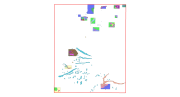
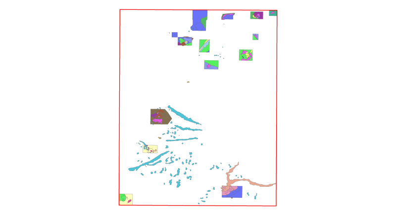
Habitats LIC Volcanes de fango del Golfo de Cádiz
This dataset contains the habitats map from the SCI (Site of Community Importance) ÔÇ£Volcanes de fango del Golfo de C├ídizÔÇØ. The Gulf of Cadiz is located in the eastern sector of the North Atlantic Ocean, to the southwest of the Iberian Peninsula. Mud Volcanoes are seafloor edifices, of a usually conical geometry, that result from the release of mud, hydrocarbon and fluids in gas-rich areas over pressured sediments. This study was supported by the INDEMARES-LIFE+ Project, EC contract INDEMARES-LIFE+ (07/NAT/E/000732): Inventory and Designation of the Natura 2000 network in marine areas of the Spanish State (www.indemares.es/en). This work was coordinated by the Spanish Institute of Oceanography (IEO, www.ieo.es) and the Biodiversity Foundation (www.fundacion-biodiversidad.es). The interpretation has been made possible thanks to direct and indirect samplings and geophysical data from campaigns INDEMARES_CHICA (CHICA0610, CHICA0211, CHICA1011 and CHICA0412). Habitats are classified according to EUNIS nomenclature and the List of Marine Habitats in Spain (LPRE, that itÔÇÖs classified hierarchically and was completed and published in March 2013).
Simple
- Alternate title
-
ES001022
- Date (Revision)
- 2015-10-05T00:00:00
- Presentation form
- Digital map
- Purpose
-
Marine habitats research and seabed habitats distribution mapping for Marine Natura 2000 Network areas declaration. It was performed with geophysical data and direct and indirect samplings obtained in the Project INDEMARES Volcanes de fango del Golfo de Cádiz (LIFE+ 07/NAT/E/000732). The study area is situated in the Gulf of Cadiz (eastern sector of the North Atlantic Ocean). We would like to thank the captains and all the crews of R/V Enma Bardán, R/V Cornide de Saavedra, R/V Vizconde de Eza and R/V Ramón Margalef.
- Status
- Completed
- Point of contact
-
Organisation name Individual name Electronic mail address Role Fundaci├│n Biodiversidad (Biodiversity Fundation)
Fundaci├│n Biodiversidad
Point of contact Instituto Español de Oceanografía (Spanish Institute of Oceanography) (IEO)
Instituto Español de Oceanografía (IEO)
Owner Instituto Español de Oceanografía (Spanish Institute of Oceanography) (IEO)
Víctor Díaz del Río Español
Principal investigator Instituto Español de Oceanografía (Spanish Institute of Oceanography) (IEO)
Jose Luis Rueda Ruiz
Principal investigator Instituto Español de Oceanografía (Spanish Institute of Oceanography) (IEO)
Alberto Serrano L├│pez
Principal investigator
- Maintenance and update frequency
- Not planned
- Theme
-
-
Marine habitat mapping
-
Benthos
-
Bentos
-
Habitat
-
Hábitat
-
Seabed
-
Fondo marino
-
LIFE
-
LIFE+
-
INDEMARES
-
Instituto Español de Oceanografía
-
FUNDACIÓN BIODIVERSIDAD
-
EMODNET
-
EUSeaMap
-
Protected sites
-
Lugares protegidos
-
mud volcano
-
volcán de fango
-
cold seep
-
surgencias frías
-
bacterial mats
-
tapetes bacterianos
-
vulnerable habitats
-
hábitat vulnerable
-
Gulf of Cádiz
-
Golfo de Cádiz
-
-
GEMET - INSPIRE themes, version 1.0
-
-
Habitats and biotopes
-
Hábitats y biotopos
-
Protected sites
-
Lugares protegidos
-
Species distribution
-
Distribuci├│n de las especies
-
Rasgos oceanográficos
-
Geology
-
Geología
-
Biology
-
Biología
-
- Use limitation
-
The use of this information, totally or partly, requires the source citation: Spanish Institute of Oceanography (IEO, www.ieo.es) and Biodiversity Fundation (www.fundacion-biodiversidad.es), Spain.
- Access constraints
- Other restrictions
- Use constraints
- Other restrictions
- Other constraints
-
The use of this information, totally or partly, requires the source citation: Spanish Institute of Oceanography (IEO, www.ieo.es) and Biodiversity Fundation (www.fundacion-biodiversidad.es), Spain.
- Spatial representation type
- Vector
- Denominator
- 400000
- Language
-
eng
- Character set
- UTF8
- Topic category
-
- Environment
- Begin date
- 2009-10-01T00:00:00
- End date
- 2013-12-02T00:00:00
))
Vertical extent
- Minimum value
- 5000
- Maximum value
- 500000
- Reference system identifier
- WGS 1984
- Distribution format
-
Name Version Esri Shapefile ESRI ArcGIS 10.1
- OnLine resource
-
Protocol Linkage Name OGC:WMS
https://ows.emodnet-seabedhabitats.eu/geoserver/emodnet_view_maplibrary/wms? es001022
OGC:WFS
https://ows.emodnet-seabedhabitats.eu/geoserver/emodnet_open_maplibrary/wfs? es001022
WWW:LINK-1.0-http--link
https://files.emodnet-seabedhabitats.eu/data/EMODnetSBHsurvey_ES001022.zip EMODnet Seabed Habitats download
- Hierarchy level
- Dataset
Conformance result
- Title
-
Habitats LIC Volcanes de fango del Golfo de Cádiz
- Date (Publication)
- 2015-10-05
- Explanation
-
EMODnetSBH Confidence assessment scoresheet = 89
- Pass
- Yes
- Statement
-
Manual translation: Each EUNIS habitat within the map was manually determined and entered by an expert.
Metadata
- File identifier
- 80351be9-20a5-408b-ab0b-61270e7bcf0e XML
- Metadata language
-
eng
- Character set
- UTF8
- Date stamp
- 2026-03-11T09:22:43.6170832Z
- Metadata standard name
-
ISO 19115:2003/19139
- Metadata standard version
-
1.0
- Metadata author
-
Organisation name Individual name Electronic mail address Role INSTITUTO ESPAÑOL DE OCEANOGRAFÍA (Spanish Institute of Oceanography) (IEO)
Instituto Español de Oceanografía (IEO)
Point of contact INSTITUTO ESPAÑOL DE OCEANOGRAFÍA (Spanish Institute of Oceanography) (IEO)
Olvido Tello Ant├│n
Custodian
Overviews
Spatial extent
)))
Provided by
