 ICES Metadata Catalogue
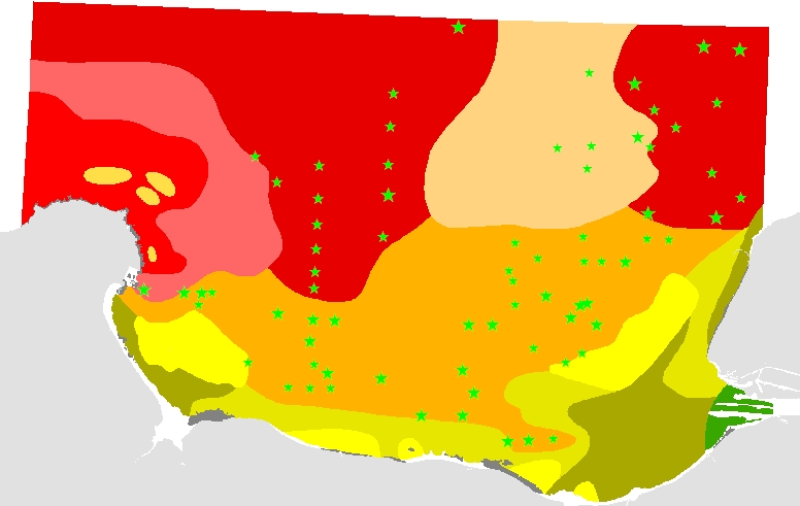
Carte des peuplements macrobenthiques de la Baie de Seine et de la Manche centrale sud (1976) au 1/117000
This map of the macrobenthic communities of the Seine Bay and south-central English Channel is reproduced from the map (scale = 1:117000) by Franck Gentil and Louis Cabioch from the Roscoff Oceanological Observatory, entitled "Carte des peuplements macrobenthiques de la Baie de Seine et de la Manche centrale sud" (Map of the macrobenthic communities of the Seine Bay and south-central English Channel) published in 1997. The documents, at the origin of this data set, are the result of research works made on the macrobenthic communities of the Seine Bay, as part of a systematic survey of the English Channel benthos. To realise this survey, 436 samples were collected between 1971 and 1976 on board the Pluteus II, a CNRS oceanographic vessel run by the Roscoff Biological Station (CNRS = Centre National de la Recherche Scientifique / French National Centre for Scientific Research).
This map was digitized in 2003, as part of the REBENT programme, i.e. the surveying network for the benthic fauna and flora. The original legend is transferred to the "ORIG_HAB" attribute data field. The harmonization with the EUNIS typology is in progress, as part of the REBENT and Interreg-MESH programmes.
Simple
- Alternate title
-
FR000002
- Alternate title
-
ifr_peupl_Gentil_BaieSeine_wgs84_p
- Date (Publication)
- 2004-07-01
- Edition date
- 2004-07-01
- Purpose
-
Research
- Credit
-
Carte des peuplements macrobenthiques de la Baie de Seine et de la Manche centrale sud (1976), au 1/117000 sous forme de polygones, REBENT digital product Ifremer-Universit├®-CNRS, 2004 Source document F. Gentil, L. Cabioch, 1997, Carte des peuplements macrobenthiques de la Baie de Seine et de la Manche centrale sud, ├®ditions de l'Observatoire Oc├®anologique de Roscoff"
- Point of contact
-
Organisation name Individual name Electronic mail address Role REBENT Ifremer-Universit├®-CNRS
Unknown
Point of contact
-
title
-
-
Communities
-
-
title
-
-
27E8; 27E9; 27F0; 28E8; 28E9; 28F0
-
- Place
-
-
Eastern Channel
-
France
-
- Theme
-
-
Rebent
-
- Use limitation
-
This REBENT product was created in partnership between Ifremer and the Roscoff Marine Station at the origin of the data source. Before any use, read the charter governing the users rights ( http://www.rebent.org/fr/cartes-interactives/conditions-d-utilisation.php?g_url=/docs/data/ifr_peupl_Gentil_BaieSeine_p.zip). These files are intended for personal use. Any commercial use of these data is strictly prohibited. For any use other than personal, please contact the Digital Data Custodian. Any modification of these data is subjected to a preliminary authorization. For that please contact B. Guillaumont, person in charge of the Cartographic Product Valuation for the REBENT project. Citation of reference is required in bibliography.
- Spatial representation type
- Vector
- Denominator
- 117000
- Character set
- UTF8
- Topic category
-
- Oceans
- Begin date
- 1971-01-01
- End date
- 1976-12-31
))
- Reference system identifier
- GCS_WGS_1984
Distributor
- Distributor contact
-
Organisation name Individual name Electronic mail address Role IFREMER| digital data custodian, D├®partement Informatique et Donn├®es Marines, SISMER, Plouzan├® D├®partement Informatique et Donn├®es Marines, SISMER
Michel BELLOUIS
Point of contact
- Distributor format
-
Name Version Unknown
Unknown
- OnLine resource
-
Protocol Linkage Name WWW:LINK-1.0-http--link
http://www.ifremer.fr/sextant/fr/web/guest/geoviewer?url=http://www.rebent.org/docs/data/Rebent_carto/BaieSeine_context.xml
- Hierarchy level
- Dataset
Conceptual consistency
- Name of measure
-
MESH Confidence Assessment
- Measure description
-
https://www.emodnet-seabedhabitats.eu/resources/mesh-archive/
Quantitative attribute accuracy
- Name of measure
-
RemoteTechnique
- Evaluation method description
-
An assessment of whether the remote techniques used to produce this map were appropriate to the environment they were used to survey: 3 = technique(s) highly appropriate 2 = technique(s) moderately appropriate 1 = technique(s) inappropriate
Completeness commission
- Name of measure
-
RemoteCoverage
- Evaluation method description
-
An assessment of the coverage of the remote sensing data including consideration of heterogeneity of the seabed: (See Coverage X Heterogeneity matrix below) Coverage scores - use these to determine coverage then combine with heterogeneity assessment to derive finale scores 3 = good coverage; 100% (or greater) coverage or AGDS track spacing <50m 2 = moderate coverage; swath approx 50% coverage or AGDS track spacing >100m 1 = poor coverage; large gaps between swaths or AGDS track spacing > 100m Final scores 3 = good coverage OR moderate coverage + low heterogeneity 2 = moderate coverage + moderate heterogeneity OR poor coverage + low heterogeneity 1 = moderate coverage + high heterogeneity OR poor coverage + moderate or high heterogeneity
Relative internal positional accuracy
- Name of measure
-
RemotePositioning
- Evaluation method description
-
An indication of the positioning method used for the remote data: 3 = differential GPS 2 = GPS (not differential) or other non-satellite 'electronic' navigation system 1 = chart based navigation, or dead-reckoning
Topological consistency
- Name of measure
-
RemoteStdsApplied
- Evaluation method description
-
An assessment of whether standards have been applied to the collection of the remote data. This field gives an indication of whether some data quality control has been carried out: 3 = remote data collected to approved standards 2 = remote data collected to ?internal? standards 1 = no standards applied to the collection of the remote data
Temporal validity
- Name of measure
-
RemoteVintage
- Evaluation method description
-
An indication of the age of the remote data: 3 = < 5yrs old. 2 = 5 to 10 yrs old. 1 = > 10 years old
Non quantitative attribute accuracy
- Name of measure
-
BGTTechnique
- Evaluation method description
-
An assessment of whether the ground-truthing techniques used to produce this map were appropriate to the environment they were used to survey. Use scores for soft or hard substrata as appropriate to the area surveyed. Soft substrata predominate (i.e. those having infauna and epifauna) 3 = infauna AND epifauna sampled AND observed (video/stills, direct human observation) 2= infauna AND epifauna sampled, but NOT observed (video/stills, direct human observation) 1 = infauna OR epifauna sampled, but not both. No observation. Hard substrata predominate (i.e. those with no infauna) 3 = sampling included direct human observation (shore survey or diver survey) 2 = sampling included video or stills but NO direct human observation 1 = benthic sampling only (e.g. grabs, trawls)
Non quantitative attribute accuracy
- Name of measure
-
PGTTechnique
- Evaluation method description
-
An assessment of whether the combination of geophysical sampling techniques were appropriate to the environment they were used to survey. Use scores for soft or hard substrata as appropriate to the area surveyed. Soft substrata predominate (i.e. gravel, sand, mud) 3 = full geophysical analysis (i.e. granulometry and/or geophysical testing (penetrometry, shear strenght etc)) 2 = sediments described following visual inspection of grab or core samples (e.g. slightly shelly, muddy sand) 1 = sediments described on the basis of remote observation (by camera). Hard substrata predominate (i.e. rock outcrops, boulders, cobbles) 3 = sampling included in-situ, direct human observation (shore survey or diver survey) 2 = sampling included video or photographic observation, but NO in-situ, direct human observation 1 = samples obtained only by rock dredge (or similar)
Relative internal positional accuracy
- Name of measure
-
GTPositioning
- Evaluation method description
-
An indication of the positioning method used for the ground-truth data: 3 = differential GPS 2 = GPS (not differential) or other non-satellite 'electronic' navigation system 1 = chart based navigation, or dead-reckoning
Completeness commission
- Name of measure
-
GTDensity
- Evaluation method description
-
An assessment of what proportion of the polygons or classes (groups of polygons with the same ?habitat? attribute) actually contain ground-truth data: 3 = Every class in the map classification was sampled at least 3 times 2 = Every class in the map classification was sampled 1 = Not all classes in the map classification were sampled (some classes have no ground-truth data)
Conceptual consistency
- Name of measure
-
GTStdsApplied
- Evaluation method description
-
An assessment of whether standards have been applied to the collection of the ground-truth data. This field gives an indication of whether some data quality control has been carried out: 3 = ground-truth samples collected to approved standards 2 = ground-truth samples collected to 'internal' standards 1 = no standards applied to the collection of ground-truth samples
Temporal validity
- Name of measure
-
GTVintage
- Evaluation method description
-
An indication of the age of the ground-truth data: 3 = < 5 yrs old 2 = 5 to 10 yrs old 1 = > 10 years old
Topological consistency
- Name of measure
-
GTInterpretation
- Evaluation method description
-
An indication of the confidence in the biological interpretation of the ground-truthing data: 3 = Evidence of expert interpretation; full descriptions and taxon list provided for each habitat class 2 = Evidence of expert interpretation, but no detailed description or taxon list supplied for each habitat class 1 = No evidence of expert interpretation; limited descriptions available
Completeness commission
- Name of measure
-
RemoteInterpretation
- Evaluation method description
-
An indication of the confidence in the interpretation of the remotely sensed data: 3 = Appropriate technique used and documentation provided 2 = Appropriate technique used but no documentation provided 1 = Inappropriate technique used Note that interpretation techniques can range from ?by eye? digitising of side scan by experts to statistical classification techniques.
Completeness commission
- Name of measure
-
DetailLevel
- Evaluation method description
-
The level of detail to which the 'habitat' classes in the map have been classified: 3 = Classes defined on the basis of detailed biological analysis 2 = Classes defined on the basis of major characterising species or lifeforms 1 = Classes defined on the basis of physical information, or broad biological zones
Thematic classification correctness
- Name of measure
-
MapAccuracy
- Evaluation method description
-
A test of the accuracy of the map: 3 = high accuracy, proven by external accuracy assessment 2 = high accuracy, proven by internal accuracy assessment 1 = low accuracy, proved by either external or internal assessment OR no accuracy assessment made
Domain consistency
- Name of measure
-
Remote
Domain consistency
- Name of measure
-
GT
Domain consistency
- Name of measure
-
Interpretation
- Statement
-
Survey technique(s): Dredges ; Diver video ; Other
- Description
-
Classification scheme: Local
- Description
-
Classification scheme details: The resultant substrates and habitats, which various categories are listed below, are described in the attribute tables : - Fonds rocheux ; - Peuplement des cailloutis plus ou moins graveleux : faci├¿s type ; - Peuplement des cailloutis plus ou moins graveleux sous fort hydrodynamisme : faci├¿s des cailloutis purs ; - Peuplement des cailloutis plus ou moins graveleux sous fort hydrodynamisme : faci├¿s d'appauvrissement ; - Peuplement des graviers plus ou moins ensabl├®s : faci├¿s type ; - Peuplement des graviers plus ou moins ensabl├®s : faci├¿s d'appauvrissement ; - Bancs hydrodynamiques de sables grossiers ├á faune r├®duite ; - Peuplement des sables fins ├á moyens propres ├á Ophelia borealis ; - Peuplement des sables fins envas├®s ├á Abra alba - Pectinaria koreni ; - Peuplement des s├®diments h├®t├®rog├¿nes sous influence p├®litique ├á Pista cristata ; - Peuplement des vases d'estuaire ├á Macoma balthica ; The harmonization with the EUNIS typology is in progress, as part of the REBENT and Interreg-MESH programmes.
- Description
-
Survey technique details: Resolution of data : Unknown Spatial accuracy of coordinates : Accurate to within 1 km Survey method comment : - Fields work (at sea) : -> A Rallier du Baty dredge was used for this work. The dredgings were carried out between 1971 and 1975, operating from 3 to 5 minutes on the sea bottom. The sample brought back on board by the dredge is split in several batches, among which : a batch for the granulometric analysis ; 30 dm3 of sediment (sieved on a picking table, using sea water washing and two sieves of 10 and 2mm mesh size). A description form is created for each station, on the vessel's deck when picking the sediment, giving as much details as possible on the substrate and notes on the easily identifiable macrofauna. -> In addition to the dredgings, some points needed underwater photographs (by Gentil, 1976) and submarine videos. - Laboratory work : -> Benthic samples sorting : 472 species were selected for the biocenotic analysis ; -> Granulometric analysis of samples : the results obtained were added, with others, to the database which was used to create the Map of Sediments of the English Channel (Vaslet and al., 1975, Larsonneur and al., 1982). -> Analysis of benthic data : comparing the results, obtained from the various methods used (similarity between stations and species ; correspondence factorial analysis), enabled to : check the validity of the groupings resulting from the faunistic composition, delimit, in the whole coastal zone, units defined by characteristic species, obtain a bionomic cartography. Digitizing methodology (coordinated by IFREMER DEL/AO, B. Guillaumont / Chantal Croguennec and NASCA subcontractor) : several operations were necessary to get a digital information medium (from paper documents) : Each paper map was scanned at a 400-dpi resolution, The scanned files were georeferenced, using "GeoMedia Professionnel" software, version 5.0, Digitizing was GeoMedia-based, using a large scale display (scale 10 times larger than the original document), For each polygon, the original legend (ORIG_HAB) was indicated in an attribute data field. The file resulting from the digitizing was converted into an Arcinfo coverage, in order to build and validate its topology, and then converted into a shapefile. The harmonization with the EUNIS typology is in progress, as part of the REBENT and Interreg-MESH programmes.
- Processor
-
Organisation name Individual name Electronic mail address Role Gentil, F.; Cabioch, L.
Gentil, F.; Cabioch, L.
Principal investigator
- Description
-
Mapping method: Interpolated point data; Interpolated track data; Expert judgement; Unsupervised classification
Metadata
- File identifier
- 647f3ec5-1c80-4c60-b7aa-bd1ac51ff650 XML
- Character set
- UTF8
- Date stamp
- 2022-02-24T14:44:16
- Metadata standard name
-
ISO 19115:2003/19139
- Metadata standard version
-
1.0
- Metadata author
-
Organisation name Individual name Electronic mail address Role REBENT Ifremer-Universit├®-CNRS
Unknown
Point of contact
Overviews

Spatial extent
Provided by
