 ICES Metadata Catalogue
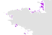
Les bancs de ma├½rl de la r├®gion Bretagne, 1968-2007 (multisource)
This comprehensive map of maerl beds in Brittany is the synthesis of various studies carried out by :
- L. Cabioch (Roscoff Biological Station, 1968),
- P. Hommeril (Geological laboratory of the Rouen Sciences university, 1968),
- P. Giresse (Geological center of the Rouen University) and P. Hommeril (Geological laboratory of the Rouen Sciences university, 1969),
- C. Chass├® and M. Gl├®marec (Universit├® de Bretagne Occidentale, 1976),
- C. R├®ti├¿re (Mus├®um National d'Histoire Naturelle, 1979),
- E. Houlgatte (Bureau d'Etudes g├®ologiques) and C. Augris (Ifremer, 1996),
- A. Ehrhold (Ifremer, 1999),
- J. Grall (Universit├® de Bretagne Occidentale/IUEM, 1999),
- C. Augris, M. Blanchard (Ifremer), C. Bonnot-Courtois (CNRS) and E. Houlgatte (Bureau d'Etudes g├®ologiques, 2000),
- J. Grall and C. Hily (Universit├® de Bretagne Occidentale/IUEM, 2002).
A number of different methods were used to produce these data sets : point observations, (grad and dredge samples, core sample) or side scan sonar surveys.
The whole set of paper maps was processed in 2003, as part of the REBENT programme, i.e. the surveying network for the benthic flora and fauna). This included digitization, labelling and validation. Maerl types are shown in the "ORIG_HAB" attribute field.
See also the "Fiche biologique de synth├¿se sur le ma├½rl" (d├®cembre 2003) : http://www.rebent.org/documents/index.php, under "Fiches biologiques de synth├¿se".
This product is meant to be updated, completed and harmonized as new data are made available.
The harmonization with the EUNIS typology was made in 2006, as part of the REBENT and Interreg-MESH programmes.
Simple
- Alternate title
-
FR000007
- Alternate title
-
ifr_maerl_Grall_BretagneCotentinouest_wgs84_p
- Date (Publication)
- 2003-11-01
- Edition date
- 2003-11-01
- Purpose
-
Research
- Credit
-
Figure 4 "R├®partition du maerl" in Giresse P., Hommeril, P., 1969, Les fonds sous-marins de la carte de Granville au 100000e. Revue de la Soci├®t├® Savante de Haute Normandie, n┬░ 56, p. 23-50 ; Hommeril, P., 1968, Carte s├®dimentologique sous-marine des c├┤tes de France au 1/100000, Zone Bricquebec ; fig. 45 "R├®partition g├®n├®rale des peuplements benthiques pr├®littoraux" in Cabioch, L., 1968, Contribution ├á la connaissance des peuplements benthiques de la Manche occidentale. Cahiers de biologie marine, tome IX, cahier 5 suppl., 720 p. ; Chass├®, C. (Ed.), Gl├®marec, M. (Ed.), avec le concours du CNEXO, 1976, Atlas du littoral fran├ºais : atlas des fonds meubles du plateau continental du golfe de Gascogne : cartes bios├®dimentaires ; Carte n┬░4 "Les peuplements benthiques du golfe normanno-breton" in Reti├¿re, C., 1979, Contribution ├á la connaissance des peuplements benthiques du golfe normanno-breton. Th├¿se de doctorat de l'Universit├® de Rennes, 431 p. ; Houlgatte, E., Augris, C., Carte de la baie de Saint-Brieuc, morpho-s├®dimentologie, nature des fonds, in Augris, C. (Coord.), Hamon, D. (Coord.) et al., 1996, Atlas th├®matique de l'environnement marin en baie de Saint-Brieuc (C├┤tes d'Armor), 72 p., 20 cartes ; Figure II-7 "Teneur en carbonates et r├®partition du maerl au Sud-Est des Iles Chausey" in Ehrhold, A., 1999, Dynamique de comblement d'un bassin s├®dimentaire soumis ├á un r├®gime m├®gatidal, exemple de la Baie du Mont Saint Michel. Th├¿se de doctorat de l'Universit├® de Caen, 294 p. ; Grall, J., 1999, Cartes originales (communications personnelles de l'auteur) dans le cadre du groupe BIOMAERL ; Augris, C. (Collab.), Blanchard, M. (Collab.), Bonnot-Courtois, C. (Collab.), Houlgatte, E. (Collab.), 2000, Carte des formations superficielles sous-marines entre le Cap Fr├®hel et Saint-Malo ; Grall, J., 2002, Biodiversit├® sp├®cifique et fonctionnelle du maerl : r├®ponses ├á la variabilit├® de l'environnement c├┤tier. Th├¿se de doctorat de l'Universit├® de Bretagne Occidentale, 302 p. ; Grall, J., Hily, C., 2002, Evaluation de la sant├® des bancs de maerl de la pointe de Bretagne, rapport de contrat DIREN Bretagne-IUEM/LEMAR, 52 p.
- Point of contact
-
Organisation name Individual name Electronic mail address Role REBENT Ifremer-Universit├®-CNRS
Unknown
Point of contact
-
title
-
-
Species
-
-
title
-
-
23E6; 23E7; 24E5; 24E6; 25E5; 26E6; 26E7; 26E8; 27E7; 27E8
-
- Place
-
-
Western Channel; Bay of Biscay; Celtic Sea
-
France
-
- Theme
-
-
Rebent
-
- Use limitation
-
This product was elaborated within the framework of REBENT, the French monitoring network for benthic flora and fauna, which associates partners belonging to various organizations. The coordination of the REBENT is carried out by Ifremer. This REBENT product was created in partnership between Ifremer, the Universit├® de Bretagne Occidentale/IUEM and the Marine Roscoff Station at the origin of the data source. Before any use, read the charter governing the users rights ( http://www.rebent.org/fr/cartes-interactives/conditions-d-utilisation.php?g_url=/docs/data/ifr_maerl_bzh_p.zip). These files are intended for personal use. Any commercial use of these data is strictly prohibited. For any use other than personal, please contact the custodian Mr. Bellouis. Any modification of these data is subjected to a preliminary authorization. For that please contact B. Guillaumont, person in charge of REBENT project.
- Spatial representation type
- Vector
- Character set
- UTF8
- Topic category
-
- Oceans
- Begin date
- 1962-01-05
- End date
- 2002-12-31
))
- Reference system identifier
- GCS_WGS_1984
Distributor
- Distributor contact
-
Organisation name Individual name Electronic mail address Role IFREMER| digital data custodian, D├®partement Informatique et Donn├®es Marines, SISMER, Plouzan├® D├®partement Informatique et Donn├®es Marines, SISMER
Michel BELLOUIS
Point of contact
- Distributor format
-
Name Version Unknown
Unknown
- OnLine resource
-
Protocol Linkage Name WWW:LINK-1.0-http--link
http://www.ifremer.fr/sextant/fr/web/guest/geoviewer?url=http://www.rebent.org/docs/data/Rebent_carto/MaerlBretagneMaj2007_context.xml
- Hierarchy level
- Dataset
Conceptual consistency
- Name of measure
-
MESH Confidence Assessment
- Measure description
-
https://www.emodnet-seabedhabitats.eu/resources/mesh-archive/
Quantitative attribute accuracy
- Name of measure
-
RemoteTechnique
- Evaluation method description
-
An assessment of whether the remote techniques used to produce this map were appropriate to the environment they were used to survey: 3 = technique(s) highly appropriate 2 = technique(s) moderately appropriate 1 = technique(s) inappropriate
Completeness commission
- Name of measure
-
RemoteCoverage
- Evaluation method description
-
An assessment of the coverage of the remote sensing data including consideration of heterogeneity of the seabed: (See Coverage X Heterogeneity matrix below) Coverage scores - use these to determine coverage then combine with heterogeneity assessment to derive finale scores 3 = good coverage; 100% (or greater) coverage or AGDS track spacing <50m 2 = moderate coverage; swath approx 50% coverage or AGDS track spacing >100m 1 = poor coverage; large gaps between swaths or AGDS track spacing > 100m Final scores 3 = good coverage OR moderate coverage + low heterogeneity 2 = moderate coverage + moderate heterogeneity OR poor coverage + low heterogeneity 1 = moderate coverage + high heterogeneity OR poor coverage + moderate or high heterogeneity
Relative internal positional accuracy
- Name of measure
-
RemotePositioning
- Evaluation method description
-
An indication of the positioning method used for the remote data: 3 = differential GPS 2 = GPS (not differential) or other non-satellite 'electronic' navigation system 1 = chart based navigation, or dead-reckoning
Topological consistency
- Name of measure
-
RemoteStdsApplied
- Evaluation method description
-
An assessment of whether standards have been applied to the collection of the remote data. This field gives an indication of whether some data quality control has been carried out: 3 = remote data collected to approved standards 2 = remote data collected to ?internal? standards 1 = no standards applied to the collection of the remote data
Temporal validity
- Name of measure
-
RemoteVintage
- Evaluation method description
-
An indication of the age of the remote data: 3 = < 5yrs old. 2 = 5 to 10 yrs old. 1 = > 10 years old
Non quantitative attribute accuracy
- Name of measure
-
BGTTechnique
- Evaluation method description
-
An assessment of whether the ground-truthing techniques used to produce this map were appropriate to the environment they were used to survey. Use scores for soft or hard substrata as appropriate to the area surveyed. Soft substrata predominate (i.e. those having infauna and epifauna) 3 = infauna AND epifauna sampled AND observed (video/stills, direct human observation) 2= infauna AND epifauna sampled, but NOT observed (video/stills, direct human observation) 1 = infauna OR epifauna sampled, but not both. No observation. Hard substrata predominate (i.e. those with no infauna) 3 = sampling included direct human observation (shore survey or diver survey) 2 = sampling included video or stills but NO direct human observation 1 = benthic sampling only (e.g. grabs, trawls)
Non quantitative attribute accuracy
- Name of measure
-
PGTTechnique
- Evaluation method description
-
An assessment of whether the combination of geophysical sampling techniques were appropriate to the environment they were used to survey. Use scores for soft or hard substrata as appropriate to the area surveyed. Soft substrata predominate (i.e. gravel, sand, mud) 3 = full geophysical analysis (i.e. granulometry and/or geophysical testing (penetrometry, shear strenght etc)) 2 = sediments described following visual inspection of grab or core samples (e.g. slightly shelly, muddy sand) 1 = sediments described on the basis of remote observation (by camera). Hard substrata predominate (i.e. rock outcrops, boulders, cobbles) 3 = sampling included in-situ, direct human observation (shore survey or diver survey) 2 = sampling included video or photographic observation, but NO in-situ, direct human observation 1 = samples obtained only by rock dredge (or similar)
Relative internal positional accuracy
- Name of measure
-
GTPositioning
- Evaluation method description
-
An indication of the positioning method used for the ground-truth data: 3 = differential GPS 2 = GPS (not differential) or other non-satellite 'electronic' navigation system 1 = chart based navigation, or dead-reckoning
Completeness commission
- Name of measure
-
GTDensity
- Evaluation method description
-
An assessment of what proportion of the polygons or classes (groups of polygons with the same ?habitat? attribute) actually contain ground-truth data: 3 = Every class in the map classification was sampled at least 3 times 2 = Every class in the map classification was sampled 1 = Not all classes in the map classification were sampled (some classes have no ground-truth data)
Conceptual consistency
- Name of measure
-
GTStdsApplied
- Evaluation method description
-
An assessment of whether standards have been applied to the collection of the ground-truth data. This field gives an indication of whether some data quality control has been carried out: 3 = ground-truth samples collected to approved standards 2 = ground-truth samples collected to 'internal' standards 1 = no standards applied to the collection of ground-truth samples
Temporal validity
- Name of measure
-
GTVintage
- Evaluation method description
-
An indication of the age of the ground-truth data: 3 = < 5 yrs old 2 = 5 to 10 yrs old 1 = > 10 years old
Topological consistency
- Name of measure
-
GTInterpretation
- Evaluation method description
-
An indication of the confidence in the biological interpretation of the ground-truthing data: 3 = Evidence of expert interpretation; full descriptions and taxon list provided for each habitat class 2 = Evidence of expert interpretation, but no detailed description or taxon list supplied for each habitat class 1 = No evidence of expert interpretation; limited descriptions available
Completeness commission
- Name of measure
-
RemoteInterpretation
- Evaluation method description
-
An indication of the confidence in the interpretation of the remotely sensed data: 3 = Appropriate technique used and documentation provided 2 = Appropriate technique used but no documentation provided 1 = Inappropriate technique used Note that interpretation techniques can range from ?by eye? digitising of side scan by experts to statistical classification techniques.
Completeness commission
- Name of measure
-
DetailLevel
- Evaluation method description
-
The level of detail to which the 'habitat' classes in the map have been classified: 3 = Classes defined on the basis of detailed biological analysis 2 = Classes defined on the basis of major characterising species or lifeforms 1 = Classes defined on the basis of physical information, or broad biological zones
Thematic classification correctness
- Name of measure
-
MapAccuracy
- Evaluation method description
-
A test of the accuracy of the map: 3 = high accuracy, proven by external accuracy assessment 2 = high accuracy, proven by internal accuracy assessment 1 = low accuracy, proved by either external or internal assessment OR no accuracy assessment made
Domain consistency
- Name of measure
-
Remote
Domain consistency
- Name of measure
-
GT
Domain consistency
- Name of measure
-
Interpretation
- Statement
-
Survey technique(s): Cores ; Dredges ; Aerial photography ; Side scan sonar ; Grabs
- Description
-
Classification scheme: EUNIS
- Description
-
Classification scheme details: EUNIS classification : - A5.51 : Maerl beds
- Description
-
Survey technique details: Hommeril, P., 1968, Carte s├®dimentologique sous-marine des c├┤tes de France au 1/100000, zone de Bricquebec : Surveys at sea and laboratory work were conducted between 1962 and 1967. Dredge samples were collected between 01/05/1962 and 19/05/1966 during four surveys on board oceanographic vessel Gwadarn (ex. Kornog), under CNRS jurisdiction. Houlgatte, E., Augris, C., 1996, Carte de la baie de Saint-Brieuc, morpho-s├®dimentologie, nature des fonds : research work conducted by Ifremer between 1986 and 1993 lead to surveying the seabottom by way of various techniques: side scan sonar, sediment sampling (477 samples), remote video, coring apparatus (11 samples). Augris, C. (Collab.), Blanchard, M. (Collab.), Bonnot-Courtois, C. (Collab.), Houlgatte, E. (Collab.), 2000, Carte des formations superficielles sous-marines entre le Cap Fr├®hel et Saint-Malo : various techniques were used during oceanographic surveys : side scan sonar, sediment sampling, aerial photography (IGN-IPLI survey in 1982 over baie de la Fresnaye). Grall, J., 2002, Biodiversit├® sp├®cifique et fonctionnelle du maerl : r├®ponses ├á la variabilit├® de l'environnement c├┤tier et Grall, J., Hily, C., 2002, Evaluation de la sant├® des bancs de maerl de la pointe de Bretagne : More in depth surveys were conducted for each of the following beds : . Pourceaux Bank (Px) in the Mol├¿ne archipelago, . Camaret Bank (Ca), at the West of Roscanvel peninsula, . Rozegat Bank(Rz) (Rade de Brest), . Poulmic Bank (Po) (Rade de Brest), . Penn ar Vir Bank (Pav) (Rade de Brest), . Douarnenez Bank (Dz), . St Nicolas Bank (SN) (Glenan archipelago), . Brimillec Bank (Br) (Glenan archipelago), . Trevignon Bank (Tre). The methodologie adopted for macraufauna sampling and for maerl beds mapping was point sampling with a Smith- Mac Intyre (0.1 m┬▓) grab. At each location 6 replicates were collected with a view to better assess biodiversity. Digitizing methodology (coordinated by IFREMER DEL/AO B. Guillaumont / Chantal Croguennec, and Nasca / Ma├»a subcontractors) : several operations were necessary to get a digital information medium (from paper documents) : - Each paper map was scanned at a 400-dpi resolution, - The scanned files were georeferenced, using "GeoMedia Professionnel" software, version 5.0, - Digitizing was GeoMedia-based, using a large scale display (scale 10 times larger than the original document). The coastline used is that of Ifremer-Shom (scale = 1/25000) (date of revision 1995). - For each polygon, the original legend (ORIG_HAB) was indicated in an attribute data field. The file resulting from the digitizing was converted into an Arcinfo coverage, in order to build and validate its topology, and then converted into a shapefile. The harmonization with the EUNIS typology was made in 2006, as part of the REBENT and Interreg-MESH programmes. The method used includes a re-determination individually (i.e. using expert judgement).
- Processor
-
Organisation name Individual name Electronic mail address Role Hommeril P.; Cabioch, L.; Chass├®, C.; Gl├®marec, M.; Reti├¿re C.; Augris C.; Hamon D.; Ehrhold A.; Blanchard M.; Bonnot-Courtois C.; Houlgatte E.; Le Vot M.; Grall J.
Hommeril P.; Cabioch, L.; Chass├®, C.; Gl├®marec, M.; Reti├¿re C.; Augris C.; Hamon D.; Ehrhold A.; Blanchard M.; Bonnot-Courtois C.; Houlgatte E.; Le Vot M.; Grall J.
Principal investigator
- Description
-
Mapping method: Created by combining datasets; Expert judgement; Unsupervised classification
Metadata
- File identifier
- 61adb068-908c-484e-9f2d-04466dd8e84e XML
- Character set
- UTF8
- Date stamp
- 2022-02-24T15:13:40
- Metadata standard name
-
ISO 19115:2003/19139
- Metadata standard version
-
1.0
- Metadata author
-
Organisation name Individual name Electronic mail address Role REBENT Ifremer-Universit├®-CNRS
Unknown
Point of contact
Overviews

Spatial extent
Provided by
