 ICES Metadata Catalogue
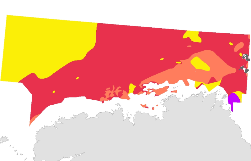
Peuplements benthiques en Manche occidentale (zone pr├®littorale) (1968) au 1/180000
Cette cartographie a ├®t├® r├®alis├®e en 2010 dÔÇÖapr├¿s la carte g├®n├®rale de la Manche occidentale de la th├¿se de Louis Cabioch (Station biologique de Roscoff) "Contribution ├á la connaissance des peuplements benthiques de la Manche occidentale" publi├®e en 1968, et compl├®t├®e pour la partie "Secteur Go├½lo" par des donn├®es originales fournies par le m├¬me auteur.
La carte au 1 / 180 000 de la th├¿se a ├®t├® num├®ris├®e en 2003 et les donn├®es du secteur Go├½lo en 2007, dans le cadre du R├®seau de surveillance de la flore et de la faune benthique marine Rebent. LÔÇÖharmonisation avec la typologie EUNIS a ├®t├® effectu├®e avec lÔÇÖexpertise de Frank Gentil.
Simple
- Alternate title
-
FR000003
- Alternate title
-
FRE-330-715-368-00032_Id190_IFR_RBT_PEUPL_MANCHE_OUEST_P
- Date (Publication)
- 2003-11-01
- Edition date
- 2003-11-01
- Purpose
-
Research
- Credit
-
Rebent
- Point of contact
-
Organisation name Individual name Electronic mail address Role REBENT Ifremer-Universit├®-CNRS
Unknown
Point of contact
-
title
-
-
Communities
-
-
title
-
-
26E4; 26E5; 26E6; 27E4; 27E5; 27E6
-
- Place
-
-
Western Channel; Celtic Sea
-
France
-
- Theme
-
-
Rebent
-
- Use limitation
-
This REBENT product was created in partnership between Ifremer and the Roscoff Marine Station at the origin of the data source. Before any use, read the charter governing the users rights ( http://www.rebent.org/fr/cartes-interactives/conditions-d-utilisation.php?g_url=/docs/data/ifr_peupl_cabioch_manche_ouest_bzh_p.zip). These files are intended for personal use. Any commercial use of these data is strictly prohibited. For any use other than personal, please contact the Digital Data Custodian. Any modification of these data is subjected to a preliminary authorization. For that please contact B. Guillaumont, person in charge of REBENT Bretagne project. Citation of reference is required in bibliography.
- Spatial representation type
- Vector
- Denominator
- 180000
- Character set
- UTF8
- Topic category
-
- Oceans
- Begin date
- 1959-01-01
- End date
- 1968-12-31
))
- Supplemental Information
-
La typologie EUNIS (CODE_EUNIS, EUNIS_FR) a permis de regrouper certains habitats de la l├®gende d'origine :
- A4.13_FR01= Cailloutis et galets circalittoraux ├á ├®pibiose sessile
- A4.2144 = Ophiures sur roche circalittorale expos├®e ├á semi-abrit├®e avec encro├╗tements
- A5.135 = S├®diment grossier sablo-graveleux ├á [Clausinella fasciata] et [Branchiostoma lanceolatum]
- A5.513 = Banc de maerl ├á [Lithothamnion coralloides] sur gravier envas├® infralittoral
La r├®alisation de cette ├®tude a n├®cessit├® environ 2400 pr├®l├¿vements entre 1959 et 1968 ├á bord des navires oc├®anographiques Pluteus II et Thalassa. Deux cartes repr├®sentant la r├®partition des peuplements et l'├®tagement ont ├®t├® notamment produites dans le document cit├® ci-dessus : une carte au 1/50 000 "R├®partition des peuplements benthiques dans la r├®gion de Roscoff" et une carte de plus grande emprise au 1/180 000 (figure 46) "R├®partition g├®n├®rale des peuplements benthiques pr├®littoraux" qui est celle d├®crite ici.
- Reference system identifier
- GCS_WGS_1984
Distributor
- Distributor contact
-
Organisation name Individual name Electronic mail address Role IFREMER| digital data custodian, D├®partement Informatique et Donn├®es Marines, SISMER, Plouzan├® D├®partement Informatique et Donn├®es Marines, SISMER
Michel BELLOUIS
Point of contact
- Distributor format
-
Name Version Esri Shapefile
1
- OnLine resource
-
Protocol Linkage Name WWW:LINK-1.0-http--link
http://www.ifremer.fr/sextant/fr/web/guest/geoviewer?url=http://www.rebent.org/docs/data/Rebent_carto/MancheOuestCabiochEunis_context.xml OGC:WMS
https://ows.emodnet-seabedhabitats.eu/geoserver/emodnet_view_maplibrary/wms? fr000003
OGC:WFS
https://ows.emodnet-seabedhabitats.eu/geoserver/emodnet_open_maplibrary/wfs? fr000003
WWW:LINK-1.0-http--link
https://files.emodnet-seabedhabitats.eu/data/EMODnetSBHsurvey_FR000003.zip EMODnet Seabed Habitats download
- Hierarchy level
- Dataset
Conceptual consistency
- Name of measure
-
MESH Confidence Assessment
- Measure description
-
https://www.emodnet-seabedhabitats.eu/resources/mesh-archive/
Quantitative attribute accuracy
- Name of measure
-
RemoteTechnique
- Evaluation method description
-
An assessment of whether the remote techniques used to produce this map were appropriate to the environment they were used to survey: 3 = technique(s) highly appropriate 2 = technique(s) moderately appropriate 1 = technique(s) inappropriate
Completeness commission
- Name of measure
-
RemoteCoverage
- Evaluation method description
-
An assessment of the coverage of the remote sensing data including consideration of heterogeneity of the seabed: (See Coverage X Heterogeneity matrix below) Coverage scores - use these to determine coverage then combine with heterogeneity assessment to derive finale scores 3 = good coverage; 100% (or greater) coverage or AGDS track spacing <50m 2 = moderate coverage; swath approx 50% coverage or AGDS track spacing >100m 1 = poor coverage; large gaps between swaths or AGDS track spacing > 100m Final scores 3 = good coverage OR moderate coverage + low heterogeneity 2 = moderate coverage + moderate heterogeneity OR poor coverage + low heterogeneity 1 = moderate coverage + high heterogeneity OR poor coverage + moderate or high heterogeneity
Relative internal positional accuracy
- Name of measure
-
RemotePositioning
- Evaluation method description
-
An indication of the positioning method used for the remote data: 3 = differential GPS 2 = GPS (not differential) or other non-satellite 'electronic' navigation system 1 = chart based navigation, or dead-reckoning
Topological consistency
- Name of measure
-
RemoteStdsApplied
- Evaluation method description
-
An assessment of whether standards have been applied to the collection of the remote data. This field gives an indication of whether some data quality control has been carried out: 3 = remote data collected to approved standards 2 = remote data collected to ?internal? standards 1 = no standards applied to the collection of the remote data
Temporal validity
- Name of measure
-
RemoteVintage
- Evaluation method description
-
An indication of the age of the remote data: 3 = < 5yrs old. 2 = 5 to 10 yrs old. 1 = > 10 years old
Non quantitative attribute accuracy
- Name of measure
-
BGTTechnique
- Evaluation method description
-
An assessment of whether the ground-truthing techniques used to produce this map were appropriate to the environment they were used to survey. Use scores for soft or hard substrata as appropriate to the area surveyed. Soft substrata predominate (i.e. those having infauna and epifauna) 3 = infauna AND epifauna sampled AND observed (video/stills, direct human observation) 2= infauna AND epifauna sampled, but NOT observed (video/stills, direct human observation) 1 = infauna OR epifauna sampled, but not both. No observation. Hard substrata predominate (i.e. those with no infauna) 3 = sampling included direct human observation (shore survey or diver survey) 2 = sampling included video or stills but NO direct human observation 1 = benthic sampling only (e.g. grabs, trawls)
Non quantitative attribute accuracy
- Name of measure
-
PGTTechnique
- Evaluation method description
-
An assessment of whether the combination of geophysical sampling techniques were appropriate to the environment they were used to survey. Use scores for soft or hard substrata as appropriate to the area surveyed. Soft substrata predominate (i.e. gravel, sand, mud) 3 = full geophysical analysis (i.e. granulometry and/or geophysical testing (penetrometry, shear strenght etc)) 2 = sediments described following visual inspection of grab or core samples (e.g. slightly shelly, muddy sand) 1 = sediments described on the basis of remote observation (by camera). Hard substrata predominate (i.e. rock outcrops, boulders, cobbles) 3 = sampling included in-situ, direct human observation (shore survey or diver survey) 2 = sampling included video or photographic observation, but NO in-situ, direct human observation 1 = samples obtained only by rock dredge (or similar)
Relative internal positional accuracy
- Name of measure
-
GTPositioning
- Evaluation method description
-
An indication of the positioning method used for the ground-truth data: 3 = differential GPS 2 = GPS (not differential) or other non-satellite 'electronic' navigation system 1 = chart based navigation, or dead-reckoning
Completeness commission
- Name of measure
-
GTDensity
- Evaluation method description
-
An assessment of what proportion of the polygons or classes (groups of polygons with the same ?habitat? attribute) actually contain ground-truth data: 3 = Every class in the map classification was sampled at least 3 times 2 = Every class in the map classification was sampled 1 = Not all classes in the map classification were sampled (some classes have no ground-truth data)
Conceptual consistency
- Name of measure
-
GTStdsApplied
- Evaluation method description
-
An assessment of whether standards have been applied to the collection of the ground-truth data. This field gives an indication of whether some data quality control has been carried out: 3 = ground-truth samples collected to approved standards 2 = ground-truth samples collected to 'internal' standards 1 = no standards applied to the collection of ground-truth samples
Temporal validity
- Name of measure
-
GTVintage
- Evaluation method description
-
An indication of the age of the ground-truth data: 3 = < 5 yrs old 2 = 5 to 10 yrs old 1 = > 10 years old
Topological consistency
- Name of measure
-
GTInterpretation
- Evaluation method description
-
An indication of the confidence in the biological interpretation of the ground-truthing data: 3 = Evidence of expert interpretation; full descriptions and taxon list provided for each habitat class 2 = Evidence of expert interpretation, but no detailed description or taxon list supplied for each habitat class 1 = No evidence of expert interpretation; limited descriptions available
Completeness commission
- Name of measure
-
RemoteInterpretation
- Evaluation method description
-
An indication of the confidence in the interpretation of the remotely sensed data: 3 = Appropriate technique used and documentation provided 2 = Appropriate technique used but no documentation provided 1 = Inappropriate technique used Note that interpretation techniques can range from ?by eye? digitising of side scan by experts to statistical classification techniques.
Completeness commission
- Name of measure
-
DetailLevel
- Evaluation method description
-
The level of detail to which the 'habitat' classes in the map have been classified: 3 = Classes defined on the basis of detailed biological analysis 2 = Classes defined on the basis of major characterising species or lifeforms 1 = Classes defined on the basis of physical information, or broad biological zones
Thematic classification correctness
- Name of measure
-
MapAccuracy
- Evaluation method description
-
A test of the accuracy of the map: 3 = high accuracy, proven by external accuracy assessment 2 = high accuracy, proven by internal accuracy assessment 1 = low accuracy, proved by either external or internal assessment OR no accuracy assessment made
Domain consistency
- Name of measure
-
Remote
Domain consistency
- Name of measure
-
GT
Domain consistency
- Name of measure
-
Interpretation
- Statement
-
Survey technique(s): Dredges ; Diver video ; Drop camera ; Other
- Description
-
Classification scheme: EUNIS
- Description
-
Classification scheme details: EUNIS classification : - A4.13_FR01 : Proposed EUNIS habitat type: Sessile fauna on circalittoral coarses gravels and cobbles - A4.2144 : Brittlestars on faunal and algal encrusted exposed to moderately wave-exposed circalittoral rock - A5.135 : [Branchiostoma lanceolatum] in circalittoral coarse sand with shell gravel
- Description
-
Survey technique details: Resolution of data : >1000 m Spatial accuracy of coordinates : Accurate to within 1 km * Survey method comment : variable intervals between the stations (0,3 milles near the coast and more than 3 milles offshore) ; Rallier du Baty dredge = 1913 dredgings ; Faubert sampling ; Rectangular dredge (for maerl beds) ; After 1965, each dredging was supplemented by underwater photographs ; In some places, underwater video. * Digitizing methodology (coordinated by IFREMER DEL/AO, B. Guillaumont / Chantal Croguennec and NASCA subcontractor) : several operations were necessary to get a digital information medium (from paper documents) : - Each paper map was scanned at a 400-dpi resolution, - The scanned files were georeferenced, using "GeoMedia Professionnel" software, version 5.0, - Digitizing was GeoMedia-based, using a large scale display (scale 10 times larger than the original document). The reference coastline used is the so-called "Ifremer-Shom" on scale = 1/25000 (updated in 1995). - The original legend was transferred to the "ORIG_HAB" attribute data field. The file resulting from the digitizing was converted into an Arcinfo coverage, in order to build and validate its topology, and then converted into a shapefile. The harmonization with the EUNIS typology was made in 2006, as part of the REBENT and Interreg-MESH programmes. The method used include a re-determination individually (i.e. using expert judgement).
- Processor
-
Organisation name Individual name Electronic mail address Role Cabioch, L.
Cabioch, L.
Principal investigator
- Description
-
Mapping method: Interpolated point data; Interpolated track data; Expert judgement; Unsupervised classification
Metadata
- File identifier
- 576ebc04-fe07-4ce1-ba56-564673715b2c XML
- Character set
- UTF8
- Date stamp
- 2022-02-24T14:44:00
- Metadata standard name
-
ISO 19115:2003/19139
- Metadata standard version
-
1.0
- Metadata author
-
Organisation name Individual name Electronic mail address Role REBENT Ifremer-Universit├®-CNRS
Unknown
Point of contact
Overviews

Spatial extent
Provided by
