 ICES Metadata Catalogue
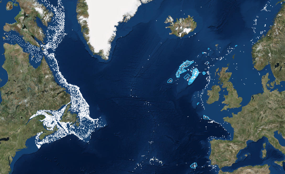
ICES Vulnerable Marine Ecosystem (VME) indicators and habitats data
VME data portal is a central portal for data on the distribution and abundance of Vulnerable Marine Ecosystems (VMEs), (and organisms considered to be indicators of VMEs) across the North Atlantic that has been set up by the Joint ICES/NAFO Working Group on Deep-water Ecology (WGDEC) and is hosted by ICES. The database is comprised of 'VME habitats' and 'VME indicators' records.
The VME database serves multiple purposes; ICES uses it for providing scientifically-robust advice on the distribution of VMEs and recommending possible management solutions such as bottom fishing closures within NEAFC (North East Atlantic Fisheries Commission) waters to protect VMEs.
Simple
- Date (Publication)
- 2016
- Edition
-
2017
- Citation identifier
- https://gis.ices.dk/geonetwork/srv/metadata/50051026-435d-4554-9692-4cb2f62ab5f9
- Presentation form
- Digital map
- Purpose
-
A working tool for tracking the VME distribution pattern and for management solutions
- Status
- On going
- Point of contact
-
Organisation name Individual name Electronic mail address Role ICES
ICES Data manager
Distributor
- Maintenance and update frequency
- Annually
- Theme
-
-
ICES
-
VME
-
NAFO
-
WGDEC
-
VMEs
-
indicators
-
Vulnerable Marine Ecosystems
-
habitats
-
- Place
-
-
NORTH ATLANTIC
-
-
GEMET - INSPIRE themes, version 1.0
-
-
Protected sites
-
Species distribution
-
- Access constraints
- Restricted
- Other constraints
- public access limited according to Article 13(1)(h) of the INSPIRE Directive (for restricted data)
- Other constraints
- no limitations to public access (for public data)
- Use constraints
- Other restrictions
- Other constraints
-
Restricted data available under the data licence for biodiversity data managed by ICES
- Other constraints
-
Public data Available under the Creative Commons Attribution (CC-BY) License v4.0
- Use limitation
-
Restricted data available under the data licence for biodiversity data managed by ICES
- Use limitation
-
Public data available under the Creative Commons Attribution (CC-BY) License v4.0
- Spatial representation type
- Vector
- Language
-
eng
- Character set
- UTF8
- Topic category
-
- Biota
- Begin date
- 1958
))
- Supplemental Information
-
While ICES has made every effort to ensure that this stomach content dataset presented here is the most complete set of information, it should be noted that there are a number of versions of this dataset held by institutions and individuals which may differ from this set.
- Reference system identifier
- WGS 1984
- Distribution format
-
Name Version ZIP
1
- OnLine resource
-
Protocol Linkage Name WWW:LINK-1.0-http--link
http://vme.ices.dk/ VME Homepage
WWW:LINK-1.0-http--link
http://vme.ices.dk/map.aspx VME Map view of data with additional features
- Hierarchy level
- Dataset
Conformance result
- Date (Publication)
- 2010-11-23
- Pass
- Yes
- Statement
-
ICES is a receiver of Marine Data from national programmes and other marine institutes, therefore ICES is not the primary collection point of marine evidence that it holds and disseminates to the users of the data.
Data are quality assured using internal and external programmes. For example, the national laboratories that take part in monitoring programmes related to contaminants and biological effects that submit information to ICES, subscribe to the Quality Assurance of Information for Marine Environmental Monitoring in Europe (QUASIMEME) or the Biological Effects Quality Assurance in Monitoring Programmes (BEQUALM) inter-laboratory proficiency-testing schemes and perform internal quality assurance. ICES operates through a network of scientific expert and advisory groups. These groups, and the processes they feed into, act as a quality check on the marine evidence, both in terms of how the evidence was gathered and how the evidence has been subsequently treated. The groups, in cooperation with regional programmes under the Regional Sea Conventions, set standards and guidelines for the collection, transmission and analysis of these data.
In addition, the ICES Secretariat provides supplementary quality assurance through its internal programmes related to the different types of marine data collection datasets, which is fedback to the participating national and regional programmes. These internal and external programmes and procedures have been established over a period of 30 or more years. They continue to evolve and strive to reflect the best available practices in the collection and treatment of marine data relevant to the ICES community.
Metadata
- File identifier
- 50051026-435d-4554-9692-4cb2f62ab5f9 XML
- Metadata language
-
eng
- Character set
- UTF8
- Hierarchy level
- Dataset
- Date stamp
- 2024-01-05T18:44:22.499Z
- Metadata standard name
-
ISO 19115:2003/19139
- Metadata standard version
-
1.0
- Metadata author
-
Organisation name Individual name Electronic mail address Role ICES
ICES Data manager
Originator
Overviews
Spatial extent
Provided by
