 ICES Metadata Catalogue
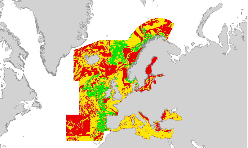
EUSeaMap (2019) Broad-Scale Predictive Habitat Map - Confidence in Biological Zones
Confidence in the 2019 EUSeaMap Biological Zone layer, produced by EMODnet Seabed Habitats for the 2019 EUSeaMap broad-scale predictive habitat maps.
Values are on a range from 1 (Low confidence) to 3 (High confidence).
Confidence in Biological Zone are driven by the confidence in the source data used to determine the descriptor, and the confidence in the threshold/margin between classes (areas closer to a boundary between two classes will have lower confidence).
Confidence values are also available for the input data layers used to model Biological Zone.
For details on methodology see Section 2.7.2 and Confidence appendix in:
Populus J. et al 2017. EUSeaMap, a European broad-scale seabed habitat map. Ifremer.
Simple
- Date (Revision)
- 2017-06-12
- Date (Publication)
- 2016-09-30
- Credit
-
EMODnet broad-scale seabed habitat map for Europe (2016), licensed under CC-BY 4.0 from the European Marine Observation and Data Network (EMODnet) Seabed Habitats initiative (www.emodnet-seabedhabitats.eu), funded by the European Commission.
- Status
- Obsolete
- Point of contact
-
Organisation name Individual name Electronic mail address Role EMODnet Seabed Habitats
Owner
- OnLine resource
-
Protocol Linkage Name WWW:LINK
https://archimer.ifremer.fr/doc/00636/74782/ EUSeaMap 2019 Techical report and MSFD Look up tables
WWW:DOWNLOAD
https://files.emodnet-seabedhabitats.eu/data/EUSM2019_BiologicalZone.zip EUSeaMap 2019 biological zone download
- Access constraints
- Other restrictions
- Other constraints
- no limitations on public access
- Use constraints
- Other restrictions
- Other constraints
-
Available under the Creative Commons (CC-BY) License v4.0 https://creativecommons.org/licenses/by/4.0/
- gmd:useconstraints
- otherRestrictions
- Other constraints
-
Attribution statement to use with the data "Copyright EMODnet Seabed Habitats 2019"
- Denominator
- 250000
- Denominator
- 250000
- Language
- English
- Topic category
-
- Biota
- Environment
- Oceans
))
- Begin date
- 1975-01-01
- End date
- 2015-12-31
- Reference system identifier
- EPSG / WGS 84 (EPSG:4326) / 7.4
- Distribution format
-
- OnLine resource
-
Protocol Linkage Name WWW:LINK-1.0-http--link
http://archimer.ifremer.fr/doc/00388/49975/ EUSeaMap. A European broad-scale seabed habitat map
WWW:LINK-1.0-http--link
https://files.emodnet-seabedhabitats.eu/data/EUSM2019_BiologicalZone.zip
- Hierarchy level
- Dataset
Conformance result
- Date (Publication)
- Pass
- Statement
-
For details on methodology and input layers see:
Populus J. And Vasquez M. (Eds), 2017. EUSeaMap, a European broad-scale seabed habitat map. Ifremer
Available from: http://archimer.ifremer.fr/doc/00388/49975/
Metadata
- File identifier
- 3954326d-f91a-495b-86b6-c5a80a1b3ec3 XML
- Metadata language
- English
- Character set
- MD_CharacterSetCode_utf8
- Parent identifier
-
EUSeaMap (2016) Broad-Scale Predictive Habitat Map - Biological Zones - ARCHIVED
ad20fbc7-37d4-40b5-a246-8cdb321e4654
- Hierarchy level
- Dataset
- Hierarchy level name
-
a
- Hierarchy level name
-
b
- Date stamp
- 2025-04-28T10:01:04.3926075Z
- Metadata standard name
-
ISO19115
- Metadata standard version
-
2003/Cor.1:2006
- Metadata author
-
Organisation name Individual name Electronic mail address Role EMODnet Seabed Habitats
Point of contact

)))