 ICES Metadata Catalogue
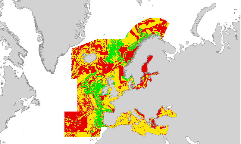
EUSeaMap (2019) Broad-Scale Predictive Habitat Map - Confidence in classification of substrate type
Confidence in the classification of substrate type in the 2019 EUSeaMap broad-scale predictive habitat map.
Values are on a range from 1 (Low confidence) to 3 (High confidence).
Substrate type is one of the layers of information used to categorise physical habitat types in EUSeaMap; these layers of information are collectively known as 'habitat descriptors'. The substrate layer confidence was obtained from reclassification and standardisation of the confidence scores associated with each primary layer used to create the Substrate types layer.
Detailed information on the modelling process for the 2016 is found in section 2.7.2 of the EMODnet Seabed Habitats technical report and its appendices (Populus et al, 2017, link in Resources). We are working on an updated report for the 2019 version.
Created by the EMODnet Seabed Habitats project consortium.
Simple
- Date (Revision)
- 2017-06-12
- Date (Publication)
- 2019-05-03
- Credit
-
Licensed under CC-BY 4.0 from the European Marine Observation and Data Network (EMODnet) Seabed Habitats initiative (www.emodnet-seabedhabitats.eu), funded by the European Commission.
- Status
- Completed
- Point of contact
-
Organisation name Individual name Electronic mail address Role EMODnet Seabed Habitats
emodnetseabedhabitats@jncc.gov emodnetseabedhabitats@jncc.gov.uk
Owner
-
GEMET - INSPIRE themes, version 1.0
-
-
Habitats and biotopes
-
- Use limitation
-
Licensed under CC-BY 4.0 - please use attribution statement included within the "Credit" element.
- Access constraints
- Other restrictions
- Other constraints
-
Licensed under CC-BY 4.0 - please use attribution statement included within the "Credit" element.
- Access constraints
- Other restrictions
- Denominator
- 250000
- Denominator
- 250000
- Language
- English
- Topic category
-
- Biota
- Environment
- Oceans
))
- Begin date
- 1975-01-01
- End date
- 2015-12-31
- Reference system identifier
- EPSG / WGS 84 (EPSG:4326) / 7.4
- Distribution format
-
Name Version Web Mapping Service
1.1.0
- OnLine resource
-
Protocol Linkage Name WWW:LINK-1.0-http--link
https://ows.emodnet-seabedhabitats.eu/geoserver/emodnet_view/wms View map "EUSeaMap 2019 Confidence in Substrate Type" through the EMODnet Seabed Habitats "Map Library" Web Map Service
WWW:LINK-1.0-http--link
https://ows.emodnet-seabedhabitats.eu/geoserver/emodnet_open/wfs View map "EUSeaMap 2019 Confidence in Substrate Type" through the EMODnet Seabed Habitats "Map Library" Web Feature Service
WWW:LINK-1.0-http--link
http://archimer.ifremer.fr/doc/00388/49975/ EUSeaMap. A European broad-scale seabed habitat map
- Hierarchy level
- Dataset
Conformance result
- Date (Publication)
- Pass
- Statement
-
For details on methodology and input layers see:
Populus J. And Vasquez M. (Eds), 2017. EUSeaMap, a European broad-scale seabed habitat map. Ifremer
Available from: http://archimer.ifremer.fr/doc/00388/49975/
Metadata
- File identifier
- 2cf1e2b1-fa8a-4bcb-9ce6-4c88c929c071 XML
- Metadata language
- English
- Character set
- MD_CharacterSetCode_utf8
- Hierarchy level
- Dataset
- Hierarchy level name
-
a
- Hierarchy level name
-
b
- Date stamp
- 2021-10-25T16:01:22
- Metadata standard name
-
ISO19115
- Metadata standard version
-
2003/Cor.1:2006
- Metadata author
-
Organisation name Individual name Electronic mail address Role EMODnet Seabed Habitats
emodnetseabedhabitats@jncc.gov emodnetseabedhabitats@jncc.gov.uk
Point of contact
Overviews
Spatial extent
Provided by
