 ICES Metadata Catalogue
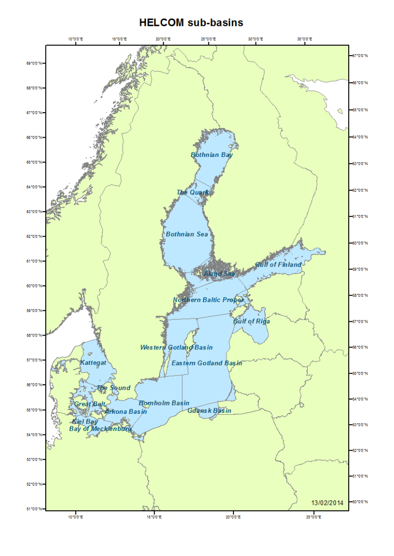
HELCOM sub-basins of the Baltic Sea
This dataset includes assessment units in subbasin scale as defined in the new HELCOM Monitoring and Assessment Strategy http://www.helcom.fi/Documents/Action%20areas/Monitoring%20and%20assessment/Monitoring%20and%20assessment%20strategy/Monitoring%20and%20assessment%20strategy.pdf published in 20 13.
Simple
- Date (Creation)
- 2013-08-28
- Date (Publication)
- 2013-08-28
- Cited responsible party
-
Organisation name Individual name Electronic mail address Role Helsinki Commission
Joni Kaitaranta
Processor
- Presentation form
- Digital map
- Theme
-
-
Baltic Sea
-
sub-basin
-
HELCOM
-
- Place
-
-
Baltic Sea
-
Northern Europe
-
- Access constraints
- otherRestictions
- Use constraints
- otherRestictions
- Other constraints
-
Data can be used freely given that the source (HELCOM) is cited.
- Other constraints
-
Data is available under the terms of the ICES Data Policy. (See: https://ices.dk/data/guidelines-and-policy/Pages/ICES-data-policy.aspx)
- Spatial representation type
- Vector
- Language
-
en
- Topic category
-
- Boundaries
- Geoscientific information
- Oceans
- Environment description
-
Microsoft Windows Vista Version 6.1 (Build 7601) Service Pack 1; ESRI ArcCatalog 9.3.1.4000
))
- Supplemental Information
-
HELCOM assessment units in subbasin scale as defined in the new HELCOM Monitoring and Assessment Strategy http://www.helcom.fi/Documents/Action%20areas/Monitoring%20and%20assessment/Monitoring%20and%20assessment%20strategy/Monitoring%20and%20assessment%20strategy.pdf published in 20 13.
Subbasin divisioning is indicated as polygons in this dataset.
- Reference system identifier
- ETRS_1989_LAEA
- Topology level
- Geometry only
- Geometric object type
- Complex
- Geometric object count
- 17
Distributor
- Distributor contact
-
Organisation name Individual name Electronic mail address Role Helsinki Commission
Joni Kaitaranta
Resource provider
- Distributor format
-
Name Version SDE Feature Class
Esri ArcGIS 10.1.0.3035
- Units of distribution
-
MB
- Transfer size
- 13.046
- OnLine resource
-
Protocol Linkage Name WWW:LINK-1.0-http--link
http://maps.helcom.fi/website/mapservice/index.html WWW:LINK-1.0-http--link
https://gis.ices.dk/gis/rest/services/External_reference_layers/HELCOM_subbasins/MapServer ArcGIS Server
- Hierarchy level
- Dataset
- Statement
-
Dataset has been prepared based on polygons of HELCOM open sea basins and merged to WFD water types and water bodies as submitted by HELCOM contracting parties. Dataset was generalized using ET Geowizards tool to reduce the file size by reducing the amount of vertices in the coastal areas.
Metadata
- File identifier
- 225df9db-bfdf-4388-8ccb-fa4b99053a36 XML
- Metadata language
- en
- Character set
- UTF8
- Hierarchy level
- Dataset
- Hierarchy level name
-
dataset
- Date stamp
- 2020-01-15T12:02:04
- Metadata standard name
-
ISO 19115:2003/19139
- Metadata standard version
-
1.0
- Metadata author
-
Organisation name Individual name Electronic mail address Role Helsinki Commission
Joni Kaitaranta
Point of contact
)))