 ICES Metadata Catalogue
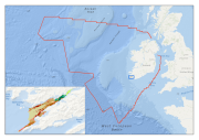
Kenmare River SAC EUNIS Habitat Map
Multibeam echosounder data and seabed sampling data acquired during the 2011 MESH Atlantic survey were the primary sources of data used in the generation of this marine habitat map. Data on kinetic energy, derived from oceanographic models, and all of the interpreted survey data, were combined in a GIS environment and used to generate a EUNIS level 5 habitat map using the Maximum Likelihood Classification tool in ArcMap.
Simple
- Alternate title
-
IE001014
- Date (Publication)
- 2013-07-02
- Date (Creation)
- 2013-07-02
- Date (Revision)
- 2013-07-02
- Citation identifier
- INSPIRE form / IE.MI.HB.MESH.ATLANTIC.KenmareRiverHabitats
- Purpose
-
Habitat map to aid in the management of Kenmare River SAC.
- Status
- Completed
- Point of contact
-
Organisation name Individual name Electronic mail address Role Marine Institute
Advanced Mapping Services
Point of contact
- Maintenance and update frequency
- Not planned
-
GEMET - Concepts, version 2.4
-
-
habitat, biotope, sea, sea bed, sediment, rock, classification
-
-
INSPIRE Feature Concept Dictionary
-
-
Habitats and biotopes
-
-
GEMET - Concepts, version 2.4
-
-
substrate
-
- Use limitation
-
licence
- Access constraints
- Other restrictions
- Other constraints
-
Marine Institute Data Licence
- Spatial representation type
- Vector
- Distance
- 1 http://standards.iso.org/ittf/PubliclyAvailableStandards/ISO_19139_Schemas/resources/uom/ML_gmxUom.xml#m
- Denominator
- 25000
- Language
- English
- Character set
- UTF8
- Topic category
-
- Oceans
- Geoscientific information
- Environment
))
- Begin date
- 2001-01-01T00:00:00
- End date
- 2005-12-31T00:00:00
Vertical extent
- Minimum value
- -80
- Maximum value
- -20
Vertical CS
Vertical datum
- Supplemental Information
-
Polygon shapefile.
- Reference system identifier
-
urn:ogc:def:crs:EPSG
/
4326
EPSG Geodetic Parameter Dataset EPSG 2009-11-25
- Distribution format
-
Name Version Esri shapefile
ArcGIS 10
- Distributor contact
-
Organisation name Individual name Electronic mail address Role Marine Institute
Advanced Mapping Services
Point of contact
- OnLine resource
-
Protocol Linkage Name OGC:WMS
https://ows.emodnet-seabedhabitats.eu/geoserver/emodnet_view_maplibrary/wms? ie001014
OGC:WFS
https://ows.emodnet-seabedhabitats.eu/geoserver/emodnet_open_maplibrary/wfs? ie001014
WWW:LINK-1.0-http--link
https://files.emodnet-seabedhabitats.eu/data/EMODnetSBHsurvey_IE001014.zip EMODnet Seabed Habitats download
- OnLine resource
-
Protocol Linkage Name WWW:LINK-1.0-http--link
http://www.meshatlantic.eu/ Project Information
WWW:LINK-1.0-http--link
https://files.emodnet-seabedhabitats.eu/data/EMODnetSBHsurvey_IE001014.zip EMODnet Seabed Habitats download
- Hierarchy level
- Dataset
Conformance result
- Alternate title
-
INSPIRE Data Specifications v3.0
- Date (Publication)
- 2011-06-15
- Explanation
-
The INSPIRE Directive or INSPIRE lays down a general framework for a Spatial Data Infrastructure (SDI) for the purposes of European Community environmental policies and policies or activities which may have an impact on the environment.
- Pass
- No
- Statement
-
Multibeam echosounder data (MBES) were collected for the MESH Atlantic survey as part of the INFOMAR national seabed mapping project. The MBES data were classified into sediment classes using information from sediment samples. These sediment classes were classified into EUNIS level 5 habitat classes using biological sample data that had been grouped into similar classes using PRIMER. Kinetic energy data derived from oceanographic models in the bay were also incorporated into the final classification. Rock outcrops were digitised from shaded relief imagery and classified to EUNIS level 5 using video footage taken along transects of the rock outcrops.
Metadata
- File identifier
- 20a8e979-ec80-4c44-b2db-f34fb2eb33f9 XML
- Metadata language
- English
- Character set
- UTF8
- Hierarchy level
- Dataset
- Date stamp
- 2021-10-29T12:10:26
- Metadata standard name
-
Based on ISO 19115:2005/19139:2007 INSPIRE Directive 2007/2/EC Metadata Implementing Rules
- Metadata standard version
-
1.2 INSPIRE Metadata Implementing Rules
- Metadata author
-
Organisation name Individual name Electronic mail address Role Marine Institute
Advanced Mapping Services
Point of contact
Overviews
Spatial extent
Provided by
