 ICES Metadata Catalogue
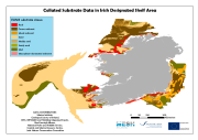
MeshAtlantic Collated Substrate Data in Ireland
Collated substrate data in the Irish Designated Shelf Area. Substrates are classified using modified Folk categories facilitating an easy transition to EUNIS. Survey and classification techniques depend on the original source/data creator of the individual component subsatrate maps that make up the entire dataset. Data contributors include the Marine Institute (Ireland), Geological Survey of Ireland, INSS, INFOMAR, HabMap, Irish Sea Fisheries, National Parks and Wildlife Service, Coastal and Marine Research Centre, and the Joint Nature Conservation Committee (UK).
Simple
- Alternate title
-
IR260774
- Date (Creation)
- 2011-04-21T17:11:00
- Edition
-
1
- Presentation form
- Digital map
- Purpose
-
To be used in the building of a broadscale EUNIS habitat map for the Irish Designated Shelf Area.
- Status
- On going
- Point of contact
-
Organisation name Individual name Electronic mail address Role Marine Institute
Eimear O'Keeffe
Point of contact
- Maintenance and update frequency
- Continual
- Theme
-
-
substrate, MeshAtlantic
-
Marine habitat mapping
-
-
INSPIRE Feature Concept Dictionary
-
-
Habitats and biotopes, Geology
-
- Use limitation
-
None
- Access constraints
- Copyright
- Spatial representation type
- Vector
- Language
-
eng
- Character set
- UTF8
- Topic category
-
- Environment
Vertical extent
))
- Reference system identifier
- WGS 1984
- Distribution format
-
Name Version ArcGIS shapefile
9.3.1
- Hierarchy level
- Dataset
Conformance result
- Date
- Pass
- Yes
Metadata
- File identifier
- 1b64cbc6-2e64-40bb-a3de-20bd6a1350f6 XML
- Metadata language
-
eng
- Character set
- UTF8
- Date stamp
- 2022-04-28T16:35:49.723Z
- Metadata standard name
-
ISO 19115:2003/19139
- Metadata standard version
-
1.0
- Metadata author
-
Organisation name Individual name Electronic mail address Role Marine Institute
Eimear O'Keeffe
Point of contact
Overviews

Spatial extent
Provided by
