 ICES Metadata Catalogue
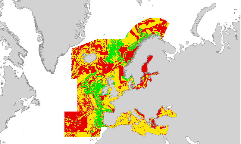
EUSeaMap2 (2016) Broad-Scale Predictive Habitat Map - Confidence in kinetic energy due to current values
Confidence in kinetic energy due to current values, produced by EMODnet Seabed Habitats for the 2016 EUSeaMap broad-scale predictive habitat maps.
Values are on a range from 1 (Low confidence) to 3 (High confidence).
The confidence assessment considered factors such as:
ÔÇó Quality of training data and methods used to construct the model.
ÔÇó Temporal resolution.
ÔÇó Spatial resolution
Detailed information on the confidence assessment in
Populus J. et al 2017. EUSeaMap, a European broad-scale seabed habitat map. Ifremer. http://doi.org/10.13155/49975
Simple
- Date (Revision)
- 2017-06-12
- Date (Publication)
- 2016-09-30
- Credit
-
EMODnet broad-scale seabed habitat map for Europe (2016), licensed under CC-BY 4.0 from the European Marine Observation and Data Network (EMODnet) Seabed Habitats initiative (www.emodnet-seabedhabitats.eu), funded by the European Commission.
- Status
- Completed
- Point of contact
-
Organisation name Individual name Electronic mail address Role EMODnet Seabed Habitats
Owner
-
GEMET - INSPIRE themes, version 1.0
-
-
Habitats and biotopes
-
- Use limitation
-
Licensed under CC-BY 4.0 - please use attribution statement included within the "Credit" element.
- Access constraints
- Other restrictions
- Other constraints
-
Licensed under CC-BY 4.0 - please use attribution statement included within the "Credit" element.
- Access constraints
- Other restrictions
- Denominator
- 250000
- Denominator
- 250000
- Language
- English
- Topic category
-
- Biota
- Environment
- Oceans
))
- Begin date
- 1975-01-01
- End date
- 2015-12-31
- Reference system identifier
- EPSG / WGS 84 (EPSG:4326) / 7.4
- Number of dimensions
- 2
- Cell geometry
- Area
- Distribution format
-
Name Version Web Mapping Service
1.1.0
- OnLine resource
-
Protocol Linkage Name WWW:LINK-1.0-http--link
http://www.emodnet-seabedhabitats.eu/access-data/launch-map-viewer/?LAYERS=EUSMWAVE_C&zoom=3&Y=51&X=-8.5 EMODnet Seabed Habitats interactive map
WWW:LINK-1.0-http--link
http://www.emodnet-seabedhabitats.eu/access-data/download-data/?linkid=1 EMODnet Seabed Habitats download page - EUSeaMap preselected
WWW:LINK-1.0-http--link
http://archimer.ifremer.fr/doc/00388/49975/ EUSeaMap. A European broad-scale seabed habitat map
OGC:WMS
https://staging.ows.emodnet-seabedhabitats.eu/emodnet_view/wms? conf_current_energy
- Hierarchy level
- Dataset
Conformance result
- Date (Publication)
- Pass
- Statement
-
For details on methodology and input layers see:
Populus J. And Vasquez M. (Eds), 2017. EUSeaMap, a European broad-scale seabed habitat map. Ifremer
Available from: http://archimer.ifremer.fr/doc/00388/49975/
Metadata
- File identifier
- 18db7569-71c0-4ec4-be40-1f28b889c487 XML
- Metadata language
- English
- Character set
- MD_CharacterSetCode_utf8
- Parent identifier
-
EUSeaMap (2016) Broad-Scale Predictive Habitat Map - Biological Zones - ARCHIVED
ad20fbc7-37d4-40b5-a246-8cdb321e4654
- Hierarchy level
- Dataset
- Hierarchy level name
-
a
- Hierarchy level name
-
b
- Date stamp
- 2020-01-15T12:17:39
- Metadata standard name
-
ISO19115
- Metadata standard version
-
2003/Cor.1:2006
- Metadata author
-
Organisation name Individual name Electronic mail address Role EMODnet Seabed Habitats
Point of contact

)))