 ICES Metadata Catalogue
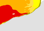
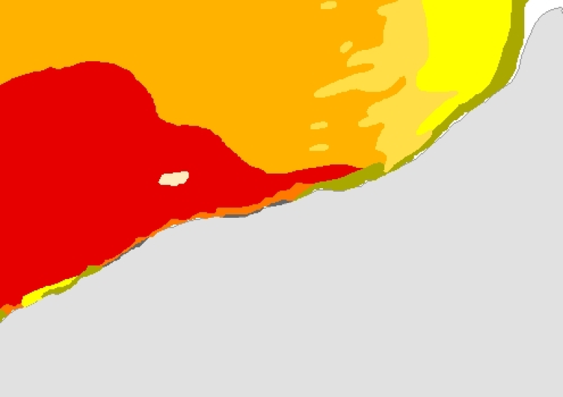
Peuplements benthiques en Manche orientale, du Cap d'Antifer à la Baie de Somme (1977) au 1/150000
This map of the benthic communities in the Eastern Channel, from the Antifer Cape to the Somme Bay, is reproduced from the map (scale = 1:650000) by Louis Cabioch from the Roscoff Oceanological Observatory and Ren├® Gla├ºon from the Wimereux Marine Station , entitled "Peuplements benthiques des fonds non-exondables (carte provisoire)" in the Eastern Channel, published in 1977.
The harmonization with the EUNIS typology is in progress, as part of the REBENT and Interreg-MESH programmes.
Simple
- Alternate title
-
FR000010
- Alternate title
-
ifr_peupl_Glacon_PaysCaux_wgs84_p
- Date (Publication)
- 2004-11-01
- Edition date
- 2004-11-01
- Purpose
-
Research
- Credit
-
Peuplements benthiques en Manche orientale, du Cap d'Antifer ├á la Baie de Somme (1977), au 1/650000 sous forme de polygones, REBENT digital product Ifremer-Universit├®-CNRS, 2004 Source document L. Cabioch, R. Gla├ºon, 1977, Distribution des peuplements benthiques en Manche orientale, du Cap d'Antifer ├á la Baie de Somme, C. R. Acad. Sc. Paris, t. 285 (18 juillet 1977), S├®rie D, p. 209-212
- Point of contact
-
Organisation name Individual name Electronic mail address Role REBENT Ifremer-Universit├®-CNRS
Unknown
Point of contact
-
title
-
-
Communities
-
-
title
-
-
28F0; 29F0; 29F1
-
- Place
-
-
Eastern Channel
-
France
-
- Keywords
-
-
Rebent
-
- Use limitation
-
This REBENT product was created in partnership between Ifremer and the Roscoff Marine Station at the origin of the data source. Before any use, read the charter governing the users rights ( http://www.rebent.org/fr/cartes-interactives/conditions-d-utilisation.php?g_url=/docs/data/ifr_peupl_Glacon_PaysCaux_p.zip). These files are intended for personal use. Any commercial use of these data is strictly prohibited. For any use other than personal, please contact the Digital Data Custodian. Any modification of these data is subjected to a preliminary authorization. For that please contact B. Guillaumont, person in charge of the Cartographic Product Valuation for the REBENT project. Citation of reference is required in bibliography.
- Spatial representation type
- Vector
- Denominator
- 150000
- Character set
- UTF8
- Topic category
-
- Oceans
- Begin date
- 1973-01-01
- End date
- 1977-06-20
))
- Supplemental Information
-
To realise this survey, 247 dredgings were carried out from 1971 on board the Pluteus II, a CNRS oceanographic vessel run by the Roscoff Biological Station, and the Henri-Emilie-II.
- Reference system identifier
- GCS_WGS_1984
Distributor
- Distributor contact
-
Organisation name Individual name Electronic mail address Role IFREMER| digital data custodian, D├®partement Informatique et Donn├®es Marines, SISMER, Plouzan├® D├®partement Informatique et Donn├®es Marines, SISMER
Michel BELLOUIS
Point of contact
- Distributor format
-
Name Version Unknown
Unknown
- OnLine resource
-
Protocol Linkage Name WWW:LINK-1.0-http--link
http://www.ifremer.fr/sextant/fr/web/guest/geoviewer?url=http://www.rebent.org/docs/data/Rebent_carto/CapAntiferBaieSomme_context.xml
- Hierarchy level
- Dataset
Conceptual consistency
- Name of measure
-
MESH Confidence Assessment
- Measure description
-
https://www.emodnet-seabedhabitats.eu/resources/mesh-archive/
Quantitative attribute accuracy
- Name of measure
-
RemoteTechnique
- Evaluation method description
-
An assessment of whether the remote techniques used to produce this map were appropriate to the environment they were used to survey: 3 = technique(s) highly appropriate 2 = technique(s) moderately appropriate 1 = technique(s) inappropriate
Completeness commission
- Name of measure
-
RemoteCoverage
- Evaluation method description
-
An assessment of the coverage of the remote sensing data including consideration of heterogeneity of the seabed: (See Coverage X Heterogeneity matrix below) Coverage scores - use these to determine coverage then combine with heterogeneity assessment to derive finale scores 3 = good coverage; 100% (or greater) coverage or AGDS track spacing <50m 2 = moderate coverage; swath approx 50% coverage or AGDS track spacing >100m 1 = poor coverage; large gaps between swaths or AGDS track spacing > 100m Final scores 3 = good coverage OR moderate coverage + low heterogeneity 2 = moderate coverage + moderate heterogeneity OR poor coverage + low heterogeneity 1 = moderate coverage + high heterogeneity OR poor coverage + moderate or high heterogeneity
Relative internal positional accuracy
- Name of measure
-
RemotePositioning
- Evaluation method description
-
An indication of the positioning method used for the remote data: 3 = differential GPS 2 = GPS (not differential) or other non-satellite 'electronic' navigation system 1 = chart based navigation, or dead-reckoning
Topological consistency
- Name of measure
-
RemoteStdsApplied
- Evaluation method description
-
An assessment of whether standards have been applied to the collection of the remote data. This field gives an indication of whether some data quality control has been carried out: 3 = remote data collected to approved standards 2 = remote data collected to ?internal? standards 1 = no standards applied to the collection of the remote data
Temporal validity
- Name of measure
-
RemoteVintage
- Evaluation method description
-
An indication of the age of the remote data: 3 = < 5yrs old. 2 = 5 to 10 yrs old. 1 = > 10 years old
Non quantitative attribute accuracy
- Name of measure
-
BGTTechnique
- Evaluation method description
-
An assessment of whether the ground-truthing techniques used to produce this map were appropriate to the environment they were used to survey. Use scores for soft or hard substrata as appropriate to the area surveyed. Soft substrata predominate (i.e. those having infauna and epifauna) 3 = infauna AND epifauna sampled AND observed (video/stills, direct human observation) 2= infauna AND epifauna sampled, but NOT observed (video/stills, direct human observation) 1 = infauna OR epifauna sampled, but not both. No observation. Hard substrata predominate (i.e. those with no infauna) 3 = sampling included direct human observation (shore survey or diver survey) 2 = sampling included video or stills but NO direct human observation 1 = benthic sampling only (e.g. grabs, trawls)
Non quantitative attribute accuracy
- Name of measure
-
PGTTechnique
- Evaluation method description
-
An assessment of whether the combination of geophysical sampling techniques were appropriate to the environment they were used to survey. Use scores for soft or hard substrata as appropriate to the area surveyed. Soft substrata predominate (i.e. gravel, sand, mud) 3 = full geophysical analysis (i.e. granulometry and/or geophysical testing (penetrometry, shear strenght etc)) 2 = sediments described following visual inspection of grab or core samples (e.g. slightly shelly, muddy sand) 1 = sediments described on the basis of remote observation (by camera). Hard substrata predominate (i.e. rock outcrops, boulders, cobbles) 3 = sampling included in-situ, direct human observation (shore survey or diver survey) 2 = sampling included video or photographic observation, but NO in-situ, direct human observation 1 = samples obtained only by rock dredge (or similar)
Relative internal positional accuracy
- Name of measure
-
GTPositioning
- Evaluation method description
-
An indication of the positioning method used for the ground-truth data: 3 = differential GPS 2 = GPS (not differential) or other non-satellite 'electronic' navigation system 1 = chart based navigation, or dead-reckoning
Completeness commission
- Name of measure
-
GTDensity
- Evaluation method description
-
An assessment of what proportion of the polygons or classes (groups of polygons with the same ?habitat? attribute) actually contain ground-truth data: 3 = Every class in the map classification was sampled at least 3 times 2 = Every class in the map classification was sampled 1 = Not all classes in the map classification were sampled (some classes have no ground-truth data)
Conceptual consistency
- Name of measure
-
GTStdsApplied
- Evaluation method description
-
An assessment of whether standards have been applied to the collection of the ground-truth data. This field gives an indication of whether some data quality control has been carried out: 3 = ground-truth samples collected to approved standards 2 = ground-truth samples collected to 'internal' standards 1 = no standards applied to the collection of ground-truth samples
Temporal validity
- Name of measure
-
GTVintage
- Evaluation method description
-
An indication of the age of the ground-truth data: 3 = < 5 yrs old 2 = 5 to 10 yrs old 1 = > 10 years old
Topological consistency
- Name of measure
-
GTInterpretation
- Evaluation method description
-
An indication of the confidence in the biological interpretation of the ground-truthing data: 3 = Evidence of expert interpretation; full descriptions and taxon list provided for each habitat class 2 = Evidence of expert interpretation, but no detailed description or taxon list supplied for each habitat class 1 = No evidence of expert interpretation; limited descriptions available
Completeness commission
- Name of measure
-
RemoteInterpretation
- Evaluation method description
-
An indication of the confidence in the interpretation of the remotely sensed data: 3 = Appropriate technique used and documentation provided 2 = Appropriate technique used but no documentation provided 1 = Inappropriate technique used Note that interpretation techniques can range from ?by eye? digitising of side scan by experts to statistical classification techniques.
Completeness commission
- Name of measure
-
DetailLevel
- Evaluation method description
-
The level of detail to which the 'habitat' classes in the map have been classified: 3 = Classes defined on the basis of detailed biological analysis 2 = Classes defined on the basis of major characterising species or lifeforms 1 = Classes defined on the basis of physical information, or broad biological zones
Thematic classification correctness
- Name of measure
-
MapAccuracy
- Evaluation method description
-
A test of the accuracy of the map: 3 = high accuracy, proven by external accuracy assessment 2 = high accuracy, proven by internal accuracy assessment 1 = low accuracy, proved by either external or internal assessment OR no accuracy assessment made
Domain consistency
- Name of measure
-
Remote
Domain consistency
- Name of measure
-
GT
Domain consistency
- Name of measure
-
Interpretation
- Statement
-
Survey technique(s): Dredges
- Description
-
Classification scheme: Local
- Description
-
Classification scheme details: Local classification : - Peuplement des fonds durs et caillouteux infralittoraux ; - Peuplement des cailloutis et graviers circalittoraux ├á ├®pibiose sessile : faci├¿s type, aspect caillouteux ; - Peuplement des cailloutis et graviers circalittoraux ├á ├®pibiose sessile : faci├¿s type, aspect des graviers ; - Peuplement des cailloutis et graviers circalittoraux ├á ├®pibiose sessile : faci├¿s type, population dense d'Ophiothrix fragilis ; - Peuplement des cailloutis et graviers circalittoraux ├á ├®pibiose sessile : faci├¿s subc├┤tier ; - Peuplement des s├®diments grossiers ├á Amphioxus lanceolatus ; - Peuplement des sables fins ├á moyens propres ├á Ophelia borealis ; - Peuplement des sables fins plus ou moins envas├®s ├á Abra alba - Pectinaria koreni. This map was digitized in 2004, as part of the REBENT programme, i.e. the surveying network for the benthic fauna and flora. The original legend is transferred to the "ORIG_HAB" attribute data field. The harmonization with the EUNIS typology is in progress, as part of the REBENT and Interreg-MESH programmes.
- Description
-
Survey technique details: Resolution of data : Unknown Spatial accuracy : Unknown Survey method comment : To realize this survey, 190 samples were collected on board the Pluteus II, a CNRS oceanographic vessel, as part of a systematic survey of the English Channel benthos (CNRS = Centre National de la Recherche Scientifique / French National Centre for Scientific Research). 57 samples were also collected on board the Henri-Emilie II, by L. Antoine, between August 27th, 1975 and September 1st, 1975. This study was realized with the financial assistance of the C.N.E.X.O. (contract n┬░ 73/691) (CNEXO = Centre National d'EXploitation des Oc├®ans / Oceans Exploitation National Center, now Ifremer). The surveys filing by similarities analysis enable to distinguish 5 major units of communities. This work allowed the realization of the provisional map of the "Peuplements benthiques des fonds non exondables" from the Antifer Cape to Somme Bay. Digitizing methodology (coordinated by IFREMER DEL/AO, B. Guillaumont / Chantal Croguennec) : several operations were necessary to get a digital information medium (from paper documents) : - Each paper map was scanned at a 400-dpi resolution, - The scanned files were georeferenced, using ?ArcView? software, version 8.3, - Digitizing was ArcView-based, in a shapefile, using a large scale display (scale 10 times larger than the original document), - For each polygon, the original legend (ORIG_HAB) were indicated in an attribute data field. The harmonization with the EUNIS typology is in progress, as part of the REBENT and Interreg-MESH programmes.
- Processor
-
Organisation name Individual name Electronic mail address Role Cabioch, L.; Glaçon, R.; Antoine, L.
Cabioch, L.; Glaçon, R.; Antoine, L.
Principal investigator
- Description
-
Mapping method: Expert judgement; Mapped directly; Unsupervised classification
Metadata
- File identifier
- 05dfdedb-86bc-4a30-9f60-08b8ca749a18 XML
- Character set
- UTF8
- Date stamp
- 2022-02-24T15:05:38
- Metadata standard name
-
ISO 19115:2003/19139
- Metadata standard version
-
1.0
- Metadata author
-
Organisation name Individual name Electronic mail address Role REBENT Ifremer-Universit├®-CNRS
Unknown
Point of contact
Overviews
Spatial extent
Provided by
