 ICES Metadata Catalogue
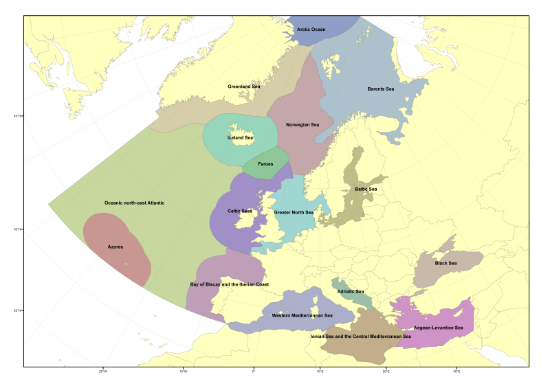
ICES Ecoregions
Delineation of the ICES Ecoregions was originally described in ICES Advice ACFM/ACE report(2004).
In the present updated version, the delineation has been updated to account for additional policy objectives and reconciling of legislation (eg the MSFD and the EU water and habitats directives)
The differences are based on the four principles:
1. Within the EU accept the MSFD regional and sub-regional definitions.
2. Separate Icelandic Seas from those around Greenland.
3. Use Large Marine Ecosystem units to define the Arctic Ocean.
4. Use the accepted Norwegian regional management plans definitions of the Norwegian and Barents Seas.
Simple
- Date (Publication)
- 2009-04-26T00:00:00
- Date (Revision)
- 2015-01-08
- Citation identifier
- https://gis.ices.dk/geonetwork/srv/metadata/4745e824-a612-4a1f-bc56-b540772166eb
- Presentation form
- Digital map
- Purpose
-
The Ecoregions were proposed to assist the implementation of the ecosystem approach in European waters
- Status
- On going
- Point of contact
-
Organisation name Individual name Electronic mail address Role ICES
Originator
- Maintenance and update frequency
- As needed
- Theme
-
- Theme
-
-
ICES Ecoregions
-
-
GEMET - INSPIRE themes, version 1.0
-
-
Administrative units
-
- Use limitation
-
Data is available under the terms of the ICES Data Policy. (See: https://ices.dk/data/guidelines-and-policy/Pages/ICES-data-policy.aspx)
- Access constraints
- Other restrictions
- Use constraints
- Other restrictions
- Other constraints
-
Data is available under the terms of the ICES Data Policy. (See: https://ices.dk/data/guidelines-and-policy/Pages/ICES-data-policy.aspx)
- Spatial representation type
- Vector
- Language
-
eng
- Character set
- UTF8
- Topic category
-
- Boundaries
))
- Reference system identifier
- WGS 1984
- OnLine resource
-
Protocol Linkage Name ArcGIS:OGC
https://gis.ices.dk/gis/rest/services/ICES_reference_layers/ICES_Ecoregions/MapServer OGC SERVICES WWW:LINK-1.0-http--link
https://gis.ices.dk/shapefiles/ICES_ecoregions.zip ICES Ecoregions shapefile
- Hierarchy level
- Dataset
Conformance result
- Date (Publication)
- 2010-12-08
- Explanation
-
See the referenced specification
- Pass
- Yes
Metadata
- File identifier
- 4745e824-a612-4a1f-bc56-b540772166eb XML
- Metadata language
-
eng
- Character set
- UTF8
- Date stamp
- 2020-01-16T12:52:45
- Metadata standard name
-
ISO 19115:2003/19139
- Metadata standard version
-
1.0
- Metadata author
-
Organisation name Individual name Electronic mail address Role ICES
Originator
Overviews

Spatial extent
Provided by
