 ICES Metadata Catalogue
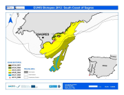
Marine biodiversity from south coast of Sagres (South of Portugal-Algarve): identification and characterization of biotopes
Under the MeshAtlantic project (2010-2013) the habitat of an area off the south coast of Portugal (Sagres) was classified. The biological data was gathered from surveys carried out during 2012. Stratified sampling by depth and bottom substrate was performed using underwater visual census, Van Veen grab and beam trawl to estimate fauna densities and quadrate method to estimate macroalgae coverage. Additional and significant data was obtained from image analysis of video records collected during Remote Operated Vehicle (ROV) surveys carried out under the UALG/CCMAR programme or from strict cooperation with the NGO OCEANA. Both these surveys began with a previous acoustic mapping of the seabed by means of Side Scan Sonar and Multi-beam, followed by sediment type classification and ground truthing validation using Van Veen grab sampling.
Simple
- Alternate title
-
PT000012
- Date (Creation)
- 2012-02-10T18:21:00
- Edition
-
2012
- Presentation form
- Digital map
- Purpose
-
Provide information on the EUNIS Habitat
- Status
- Completed
- Point of contact
-
Organisation name Individual name Electronic mail address Role University of Algarve (UAlg-FCT)- Centre of Marine Sciences (CCMAR)
Pedro Monteiro & Jorge Gonçalves
Author nstituto Español de Oceanografía (IEO)
Jos├® Luis Sanz Alonso
Author
- Maintenance and update frequency
- Not planned
- Theme
-
-
Habitat, Biocenosis, Biotope, EUNIS
-
- Place
-
-
Algarve, south Portugal, Sagres
-
- Discipline
-
-
Habitat Map
-
- Use limitation
-
The access and use is possible with request to the Regional Hydrological Administration of the Algarve (ARH Algarve) and Centre of Marine Sciences (CCMAR) of the University of Algarve (UAlg/FTC) and nstituto Español de Oceanografía (IEO)
- Access constraints
- License
- Use constraints
- License
- Spatial representation type
- Vector
- Denominator
- 25000
- Language
-
eng
- Character set
- UTF8
- Topic category
-
- Biota
- Begin date
- 2011-07-18T18:00:00
- End date
- 2012-02-10T10:00:00
))
Vertical extent
- Minimum value
- 0
- Maximum value
- -86
- Reference system identifier
- WGS 1984
- Distribution format
-
Name Version Esri Shapefile ESRI ArcGIS 9.3
- OnLine resource
-
Protocol Linkage Name WWW:LINK-1.0-http--link
https://www.emodnet-seabedhabitats.eu/resources/mesh-archive/ OGC:WMS
https://ows.emodnet-seabedhabitats.eu/geoserver/emodnet_view_maplibrary/wms? pt000012
OGC:WFS
https://ows.emodnet-seabedhabitats.eu/geoserver/emodnet_open_maplibrary/wfs? pt000012
WWW:LINK-1.0-http--link
https://files.emodnet-seabedhabitats.eu/data/EMODnetSBHsurvey_PT000012.zip EMODnet Seabed Habitats download
- Hierarchy level
- Dataset
Conformance result
- Date (Creation)
- Pass
- No
Metadata
- File identifier
- 47d9ec8b-1ba0-4657-a382-b667384bdcf2 XML
- Metadata language
-
eng
- Character set
- UTF8
- Date stamp
- 2026-03-11T09:16:35.2737944Z
- Metadata standard name
-
ISO 19115:2003/19139
- Metadata standard version
-
1.0
- Metadata author
-
Organisation name Individual name Electronic mail address Role University of Algarve (UAlg-FCT)- Centre of Marine Science (CCMAR)
Pedro Monteiro & Jorge Gonçalves
Point of contact

)))